


Summary
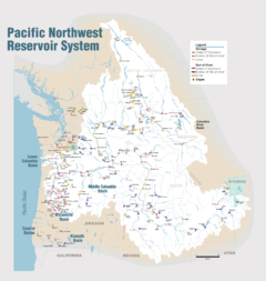
Deadwood Reservoir is a reservoir in the western United States, in Valley County, Idaho. Located in the mountains of the Boise National Forest about 25 miles (40 km) southeast of Cascade, the 3,000-acre (12 km2) body on the Deadwood River is created by Deadwood Dam. The river flows south from the dam and is a tributary of the South Fork of the Payette River. The reservoir and vicinity is commonly used for camping, water skiing, fishing, canoeing, and other outdoor recreation. The full pool surface elevation is just above a mile-high at 5,334 ft (1,626 m) above sea level.
| Deadwood Reservoir | |
|---|---|
 | |
 Deadwood Reservoir  Deadwood Reservoir | |
| Location | Valley County, Idaho, U.S.[1] |
| Coordinates | 44°17′38″N 115°38′46″W / 44.294°N 115.646°W |
| Type | reservoir |
| Primary inflows | Deadwood River[2] |
| Primary outflows | Deadwood River |
| Catchment area | 110.7 sq mi (287 km2) |
| Basin countries | United States |
| Surface area | 3,180 acres (12.9 km2; 5.0 sq mi)[3] |
| Shore length1 | 21 mi (34 km) |
| Surface elevation | 5,334 ft (1,626 m) (full pool) |
| References | [1][2][3] |
 | |
| 1 Shore length is not a well-defined measure. | |
Approved by President Calvin Coolidge in 1928, the isolated site required substantial road building. Construction of the concrete arch dam began in late 1929 and was completed in March 1931.[4]

Climate edit
Deadwood Reservoir has a dry summer humid continental climate (Köppen Dsb), with subarctic climate (Köppen Dfc) characteristics. The temperature can get hot in late July and early August. Rain and wind may frequent the area unpredictably. The climate is much like that of other high-mountain lakes in Idaho.
| Climate data for Deadwood Lodge, Idaho, 1991–2020 normals: 5948ft (1813m) | |||||||||||||
|---|---|---|---|---|---|---|---|---|---|---|---|---|---|
| Month | Jan | Feb | Mar | Apr | May | Jun | Jul | Aug | Sep | Oct | Nov | Dec | Year |
| Record high °F (°C) | 58 (14) |
59 (15) |
65 (18) |
74 (23) |
88 (31) |
93 (34) |
100 (38) |
97 (36) |
94 (34) |
87 (31) |
67 (19) |
49 (9) |
100 (38) |
| Mean maximum °F (°C) | 41.0 (5.0) |
46.1 (7.8) |
54.4 (12.4) |
64.4 (18.0) |
75.6 (24.2) |
86.5 (30.3) |
93.0 (33.9) |
91.5 (33.1) |
85.4 (29.7) |
72.6 (22.6) |
55.5 (13.1) |
40.3 (4.6) |
94.2 (34.6) |
| Mean daily maximum °F (°C) | 35.4 (1.9) |
36.0 (2.2) |
42.4 (5.8) |
49.3 (9.6) |
61.4 (16.3) |
69.6 (20.9) |
81.7 (27.6) |
81.2 (27.3) |
72.9 (22.7) |
57.0 (13.9) |
40.2 (4.6) |
31.4 (−0.3) |
54.9 (12.7) |
| Daily mean °F (°C) | 21.5 (−5.8) |
23.9 (−4.5) |
29.5 (−1.4) |
35.8 (2.1) |
45.7 (7.6) |
52.3 (11.3) |
60.6 (15.9) |
59.9 (15.5) |
52.3 (11.3) |
41.3 (5.2) |
28.4 (−2.0) |
20.2 (−6.6) |
39.3 (4.1) |
| Mean daily minimum °F (°C) | 7.6 (−13.6) |
11.8 (−11.2) |
16.5 (−8.6) |
22.3 (−5.4) |
30.0 (−1.1) |
34.9 (1.6) |
39.5 (4.2) |
38.5 (3.6) |
31.7 (−0.2) |
25.5 (−3.6) |
16.5 (−8.6) |
9.0 (−12.8) |
23.6 (−4.6) |
| Mean minimum °F (°C) | −13.2 (−25.1) |
−11.6 (−24.2) |
−2.2 (−19.0) |
9.5 (−12.5) |
18.6 (−7.4) |
26.8 (−2.9) |
30.9 (−0.6) |
29.8 (−1.2) |
23.1 (−4.9) |
14.2 (−9.9) |
−4.5 (−20.3) |
−14.3 (−25.7) |
−17.8 (−27.7) |
| Record low °F (°C) | −22 (−30) |
−22 (−30) |
−11 (−24) |
0 (−18) |
11 (−12) |
23 (−5) |
28 (−2) |
24 (−4) |
17 (−8) |
−4 (−20) |
−20 (−29) |
−24 (−31) |
−24 (−31) |
| Average precipitation inches (mm) | 4.92 (125) |
4.66 (118) |
4.78 (121) |
2.88 (73) |
3.09 (78) |
2.07 (53) |
0.63 (16) |
0.56 (14) |
1.28 (33) |
2.96 (75) |
4.26 (108) |
7.49 (190) |
39.58 (1,004) |
| Average snowfall inches (cm) | 51.1 (130) |
43.0 (109) |
30.0 (76) |
10.6 (27) |
3.0 (7.6) |
0.4 (1.0) |
0.0 (0.0) |
0.0 (0.0) |
0.2 (0.51) |
4.9 (12) |
24.0 (61) |
49.8 (126) |
217 (550.11) |
| Average extreme snow depth inches (cm) | 69.6 (177) |
78.9 (200) |
79.2 (201) |
63.8 (162) |
33.8 (86) |
1.3 (3.3) |
0.0 (0.0) |
0.0 (0.0) |
0.2 (0.51) |
4.1 (10) |
18.8 (48) |
51.1 (130) |
83.7 (213) |
| Source 1: NOAA[5] | |||||||||||||
| Source 2: XMACIS2 (records, monthly max/mins & 2000-2020 snowfall/depth)[6] | |||||||||||||
Plant life edit
- Huckleberries
- Various evergreens (mostly pine trees of one sort or another)
Wildlife edit
Fish edit
- Rainbow trout
- Kokanee salmon
- Landlock fall chinook salmon
- Bull trout
- Cutthroat trout
Mammals edit
- Chipmunks
- Deer
- Elk
- Moose
- Wolves
- Black bears
- Bats
Reptiles edit
- Garter snakes
- Rattle snakes
Birds edit
- Bald eagles
- Blue Grouse
- Osprey
- Turkey vulture
Video edit
- YouTube - video - Deadwood Reservoir - 2009-09-12
References edit
- ^ a b U.S. Geological Survey Geographic Names Information System: Deadwood Reservoir
- ^ a b "Deadwood Dam". United States Bureau of Reclamation. 1997. Archived from the original on 2008-06-27. Retrieved 2008-08-16.
- ^ a b "Boise Project - Idaho and Oregon". Bureau of Reclamation. 1997. Archived from the original on 2008-04-03. Retrieved 2008-08-16.
- ^ "The Boise Project" (PDF). U.S. Bureau of Reclamation. 1997. p. 27. Archived from the original (PDF) on 2013-03-17. Retrieved 2013-03-03.
- ^ "Deadwood Lodge, Idaho 1991-2020 Monthly Normals". Retrieved November 23, 2023.
- ^ "xmACIS". National Oceanic and Atmospheric Administration. Retrieved November 23, 2023.
- ^ List of fish from fed.us
External links edit
- U.S. Bureau of Reclamation Archived 2011-11-12 at the Wayback Machine - Deadwood Dam
- Boise National Forest – Recreation
- Recreation.gov – Deadwood Reservoir
- U.S. Bureau of Reclamation - major storage reservoirs in the Boise & Payette River basins - current levels & flows
- AirNav.com – Deadwood Dam Airstrip
- Pictures of Cascade – Deadwood Dam – July 2006
- Flickr.com – Deadwood Dam, Idaho