


Summary
Deep Springs (formerly, Deep Spring) is a set of artesian springs in Inyo County, California that were used for irrigation.[2] It lies within the treaty territory of the Western Bands of the Shoshone Nation of Indians (Timbisha Band of Western Shoshone Indians). It is located in the northeastern section of Deep Springs Valley, 22 miles (35 km) east of Bishop,[3] 2.6 km (1.6 mi) north of Soldier Pass, and 6.4 km (4 mi) southwest of Chocolate Mountain (formerly Piper Mountain),[4] at an elevation of 5194 feet (1583 m).[1]
Deep Springs | |
|---|---|
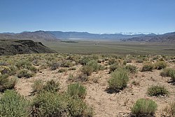 Deep Springs Valley from Gilbert Pass | |
 Deep Springs Location in California | |
| Coordinates: 37°22′18″N 117°59′06″W / 37.37167°N 117.98500°W | |
| Country | United States |
| State | California |
| County | Inyo County |
| Elevation | 5,194 ft (1,583 m) |
Deep Springs College is located in Deep Springs Valley, although not at the site of the springs. The Deep Springs post office operated from 1881 to 1883[3] and from 1920 to 1953.[3] The springs, after which the town was named, are now called Buckhorn Springs.[3]
Climate edit
| Climate data for Deer Valley, California (1981–2010) | |||||||||||||
|---|---|---|---|---|---|---|---|---|---|---|---|---|---|
| Month | Jan | Feb | Mar | Apr | May | Jun | Jul | Aug | Sep | Oct | Nov | Dec | Year |
| Record high °F (°C) | 69 (21) |
78 (26) |
81 (27) |
89 (32) |
99 (37) |
104 (40) |
110 (43) |
104 (40) |
105 (41) |
90 (32) |
80 (27) |
75 (24) |
96 (36) |
| Mean maximum °F (°C) | 61 (16) |
65 (18) |
70 (21) |
78 (26) |
87 (31) |
95 (35) |
100 (38) |
98 (37) |
92 (33) |
81 (27) |
69 (21) |
62 (17) |
99 (37) |
| Mean daily maximum °F (°C) | 47.8 (8.8) |
51.6 (10.9) |
57.8 (14.3) |
65.3 (18.5) |
75.0 (23.9) |
84.8 (29.3) |
91.6 (33.1) |
89.3 (31.8) |
81.1 (27.3) |
69.9 (21.1) |
56.2 (13.4) |
47.1 (8.4) |
68.1 (20.1) |
| Daily mean °F (°C) | 33.1 (0.6) |
38.2 (3.4) |
43.9 (6.6) |
50.2 (10.1) |
59.5 (15.3) |
68.6 (20.3) |
75.1 (23.9) |
72.9 (22.7) |
64.7 (18.2) |
53.7 (12.1) |
41.3 (5.2) |
32.9 (0.5) |
52.8 (11.6) |
| Mean daily minimum °F (°C) | 18.0 (−7.8) |
24.8 (−4.0) |
29.9 (−1.2) |
35.3 (1.8) |
44.0 (6.7) |
52.3 (11.3) |
58.5 (14.7) |
56.4 (13.6) |
48.4 (9.1) |
37.5 (3.1) |
26.5 (−3.1) |
18.8 (−7.3) |
37.5 (3.1) |
| Mean minimum °F (°C) | 6 (−14) |
12 (−11) |
18 (−8) |
24 (−4) |
32 (0) |
41 (5) |
49 (9) |
48 (9) |
38 (3) |
27 (−3) |
14 (−10) |
8 (−13) |
3 (−16) |
| Record low °F (°C) | −19 (−28) |
−11 (−24) |
−3 (−19) |
9 (−13) |
20 (−7) |
29 (−2) |
39 (4) |
38 (3) |
21 (−6) |
12 (−11) |
0 (−18) |
−15 (−26) |
−19 (−28) |
| Average precipitation inches (mm) | 0.63 (16) |
0.84 (21) |
0.68 (17) |
0.55 (14) |
0.48 (12) |
0.27 (6.9) |
0.56 (14) |
0.50 (13) |
0.41 (10) |
0.22 (5.6) |
0.46 (12) |
0.51 (13) |
6.11 (154.5) |
| Average snowfall inches (cm) | 3.4 (8.6) |
1.7 (4.3) |
0.8 (2.0) |
0.4 (1.0) |
0.0 (0.0) |
0.0 (0.0) |
0.0 (0.0) |
0.0 (0.0) |
0.0 (0.0) |
0.2 (0.51) |
0.4 (1.0) |
1.7 (4.3) |
8.6 (21.71) |
| Source: NOAA-US[5] | |||||||||||||
References edit
- ^ a b "Deep Springs". Geographic Names Information System. United States Geological Survey, United States Department of the Interior.
- ^ Waring 1915, p. 322.
- ^ a b c d Durham, David L. (1998). California's Geographic Names: A Gazetteer of Historic and Modern Names of the State. Clovis, Calif.: Word Dancer Press. p. 1159. ISBN 1-884995-14-4.
- ^ "Chocolate Mountain". Geographic Names Information System. United States Geological Survey, United States Department of the Interior.
- ^ Climate and monthly weather forecast Deer Valley, CA https://www.weather.gov/wrh/Climate?wfo=vef
Reference bibliography edit
- Waring, Gerald Ashley (1915). Springs of California. U.S. Geological Survey Water Supply Paper. Vol. 338. U.S. Government Printing Office. doi:10.3133/wsp338.