


Summary
Denman Glacier is a glacier 11 to 16 km (7 to 10 mi) wide, descending north some 110 km (70 mi), which debouches into the Shackleton Ice Shelf east of David Island, Queen Mary Land. It was discovered in November 1912 by the Western Base party of the Australasian Antarctic Expedition under Sir Douglas Mawson. Mawson named the glacier for Lord Denman, Governor-General of Australia in 1911, a patron of the expedition.[1]
| Denman Glacier | |
|---|---|
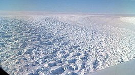 Photo of Denman Glacier | |
 Location of Denman Glacier in Antarctica | |
| Type | tributary |
| Location | Queen Mary Land |
| Coordinates | 66°45′S 99°30′E / 66.750°S 99.500°E |
| Length | 110 km (70 mi) |
| Width | 16 km (10 mi) |
| Thickness | unknown |
| Terminus | Shackleton Ice Shelf |
| Status | unknown |
The canyon under Denman Glacier has been found by the BedMachine Antarctica project (under the leadership of the University of California, Irvine)[2] to be the deepest natural location on land (or at least not under liquid water) worldwide, with the bedrock being 3,500 m (11,500 ft) below sea level.[3][4]
Calving of Denman Glacier into the Mawson Sea gives rise to the periodically appearing Pobeda Ice Island.
Instability and retreat edit
A 2020 study reported Denman Glacier has retreated 5.4±0.3 km over a 20-year-period from 1996 to 2017–2018. The study projects that the glacier has the potential to undergo a rapid, irreversible retreat, due to the presence of a retrograde bed on the western flank of the glacier and the likely presence of warm water in the sub-ice-shelf cavity. If the entirety of the glacier were hollowed out, it would contribute to a 1.5 m rise in global sea level.[5] However, as there are many factors which will determine the rate of retreat as it continues, such as the narrowness of the channel along which it is occurring and the movement of warm water from the deep ocean, it is difficult to be certain about the fate of the glacier without the collection of more data.[6]

Denman represents one of relatively few ice streams that have been identified as requiring special attention in East Antarctica, which has generally been thought of as stable compared to the West Antarctic Ice Sheet. Findings of the instability and retreat of Denman Glacier have contributed to a shift in the perception of change in East Antarctica, along with changes observed at Totten Glacier and glaciers at Vincennes Bay, Porpoise Bay, and the George V Coast.[7]
See also edit
References edit
- ^ "Denman Glacier". Geographic Names Information System. United States Geological Survey, United States Department of the Interior. Retrieved 2012-01-11.
- ^ "So that's what it's like beneath Antarctica's ice sheet: New high-precision map reveals all the bumps and hollows". Cosmos magazine. 2019-12-13. Retrieved 2019-12-13.
- ^ Jonathan Amos (December 12, 2019). "Denman Glacier: Deepest point on land found in Antarctica". BBC. Retrieved December 13, 2019.
- ^ Mathieu Morlighem; Eric Rignot; Tobias Binder; Donald Blankenship; Reinhard Drews; Graeme Eagles; Olaf Eisen; Fausto Ferraccioli; René Forsberg; Peter Fretwell; Vikram Goel; Jamin S. Greenbaum; Hilmar Gudmundsson; Jingxue Guo; Veit Helm; Coen Hofstede; Ian Howat; Angelika Humbert; Wilfried Jokat; Nanna B. Karlsson; Won Sang Lee; Kenichi Matsuoka; Romain Millan; Jeremie Mouginot; John Paden; Frank Pattyn; Jason Roberts; Sebastian Rosier; Antonia Ruppel; Helene Seroussi; Emma C. Smith; Daniel Steinhage; Bo Sun; Michiel R. van den Broeke; Tas D. van Ommen; Melchior van Wessem; Duncan A. Young (2019-12-12). "Deep glacial troughs and stabilizing ridges unveiled beneath the margins of the Antarctic ice sheet". Nature Geoscience. 13 (2): 132–137. doi:10.1038/s41561-019-0510-8. S2CID 209331991. Retrieved 2019-12-13.
- ^ Brancato, V.; Rignot, E.; Milillo, P.; Morlighem, M.; Mouginot, J.; An, L.; Scheuchl, B.; Jeong, S.; Rizzoli, P.; Bueso Bello, J.L.; Prats-Iraola, P. (2020). "Grounding line retreat of Denman Glacier, East Antarctica, measured with COSMO-SkyMed radar interferometry data". Geophysical Research Letters. 47 (7): e2019GL086291. Bibcode:2020GeoRL..4786291B. doi:10.1029/2019GL086291. ISSN 0094-8276.
- ^ Amos, Jonathan (2020-03-23). "Climate change: Earth's deepest ice canyon vulnerable to melting". BBC.
- ^ Amos, Jonathan (2018-12-11). "East Antarctica's glaciers are stirring". BBC.
66°45′S 99°30′E / 66.750°S 99.500°E
![]() This article incorporates public domain material from "Denman Glacier". Geographic Names Information System. United States Geological Survey.
This article incorporates public domain material from "Denman Glacier". Geographic Names Information System. United States Geological Survey.