
-
 Aerial view of Dicker Wilhelm (2010)
 -
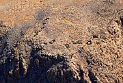 Ruins of German Schutztruppe on top of Dikwillem (Bird's eye view 2017)

KNOWPIA
WELCOME TO KNOWPIA
Dikwillem 
Summary
Dikwillem (Afrikaans) or Dicker Wilhelm (German), also known as Garub-Berg[1] or Garubberg, is a mountain in Namibia.[2] With an elevation of 1496 meters and lying within the Namib desert, the mountain is visible from a great distance from all directions. It is about 15 kilometers north of the B4 road and about 80 kilometers east of Lüderitz.
| Dicker Wilhelm | |
|---|---|
 Dicker Wilhelm with Wild Horses in front | |
| Highest point | |
| Elevation | 1,496 m (4,908 ft) |
| Coordinates | 26°28′04″S 016°01′08″E / 26.46778°S 16.01889°E |
| Naming | |
| Native name | Dikwillem (Afrikaans) |
| Geography | |
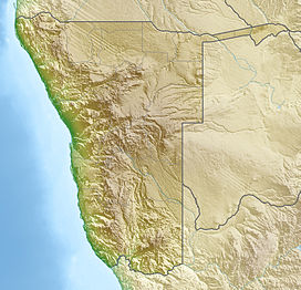 Dicker Wilhelm Position of Dicker Wilhelm | |
| Location | Namibia |
The harsh environment and barren plains around Garub[3] became the habitat of the desert horses of the Namib - descendants from German cavalry horses and adapted to the conditions and dry climate of the desert.
During the time of German colonial empire a heliographic station was operated by the German Schutztruppe on top of Dikwillem.[4]
Gallery edit


References edit