


Summary
The District Council of Franklin Harbour is a local government area in South Australia on the Eyre Peninsula. Cowell is the major population centre of an agricultural district based on farming wheat and sheep, supplemented by a fishing and oyster farming industries. The district's coastal towns including Cowell and Lucky Bay attract large numbers of tourists during school holidays, with the new Spencer Gulf ferry service increasing traffic to these areas since 2006.[4]
| District Council of Franklin Harbour South Australia | |||||||||||||||
|---|---|---|---|---|---|---|---|---|---|---|---|---|---|---|---|
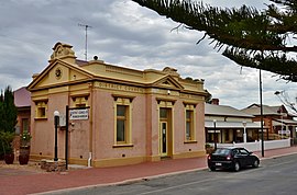 The District Council office in Cowell | |||||||||||||||
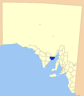 Location of the District Council of Franklin Harbour | |||||||||||||||
| Population | 1,293 (LGA 2021)[1] | ||||||||||||||
| Established | 1888 | ||||||||||||||
| Area | 3,283 km2 (1,267.6 sq mi) | ||||||||||||||
| Mayor | Robert Walsh [2] | ||||||||||||||
| Council seat | Cowell | ||||||||||||||
| Region | Eyre and Western[3] | ||||||||||||||
| State electorate(s) | Flinders | ||||||||||||||
| Federal division(s) | Grey | ||||||||||||||
 | |||||||||||||||
| Website | District Council of Franklin Harbour | ||||||||||||||
| |||||||||||||||
History edit
Franklin Harbour itself was first sighted by Matthew Flinders in 1802 and subsequently named after his midshipman and nephew, John Franklin, by Governor George Gawler in 1840. The first settlers to the region arrived in 1853, with more following soon afterward.[5]
The District Council was proclaimed in 1888.[6] In 2014, the Hundreds of Mangalo and Heggaton were transferred from the Franklin Harbour council to the District Council of Cleve.[7]
Localities edit
The district's focal point is the town of Cowell; it also includes the localities of Lucky Bay, Midgee, Miltalie, Minbrie, Mitchellville and Port Gibbon.[8]
Facilities edit
The town of Cowell has most of the normal facilities of a larger town including accommodation, supermarket, petrol station, hotel and a number of food supplying shops.
Educationally, the district is served by Cowell Area School, which includes a school-community library; with a district hospital and clinic to cover the district's health needs. A number of churches also serve the district.
There are a number of sporting clubs including cricket, football, netball, golf and bowls along with playing facilities for each sport. Cowell also has an all weather boat ramp for those with boats, as well as a jetty.[9]
Elected Members edit
| Ward | Councillor | Notes | |
|---|---|---|---|
| Unsubdivided [2] | Geoff Giles | ||
| Eddie Elleway | |||
| Robert Starr | Mayor | ||
| Daven Wagner | |||
| Robert Walsh | |||
| Michael Williams | Deputy Mayor | ||
Chairmen and mayors of Franklin Harbour edit
- Frank Laurie Williams (1925-1927) [10]
- Earnest Perry Smith (1932-1939) [10]
- John Taylor Forth (1939-1941) [10]
- Frank Laurie Williams (1941-1945) [10]
- John Pellew Story (1945-1947) [10]
- Sidney Gordon Clothier (1947-1960) [10]
- Harold Alwin Schiller (1960-1967) [10]
- William James Martin Cooper (1967-1973) [10]
- John Arthur Burton (1973-1980) [10]
- Dudley John Kaden (1981-?)
References edit
- ^ Australian Bureau of Statistics (28 June 2022). "Franklin Harbour (Local Government Area)". Australian Census 2021 QuickStats. Retrieved 28 June 2022.
- ^ a b "Contact List". District Council of Franklin Harbour. Retrieved 14 February 2016.
- ^ "Eyre Western SA Government region" (PDF). The Government of South Australia. Retrieved 10 October 2014.
- ^ Sea SA, Timetable, retrieved 18 May 2007
- ^ District Council of Franklin Harbour, History, retrieved 18 May 2007
- ^ Hosking, P. (1936). The Official civic record of South Australia : centenary year, 1936. Adelaide: Universal Publicity Company. p. 619.
- ^ "Boundary Adjustment Facilitation Panel, Annual Report 2013-14" (PDF). Parliament of South Australia. Retrieved 4 December 2015.
- ^ "Location SA Map Viewer". Government of South Australia. Retrieved 14 February 2016.
- ^ District Council of Franklin Harbour, General information, archived from the original on 26 April 2007, retrieved 18 May 2007
- ^ a b c d e f g h i Matthews, Penny (1986), South Australia, the civic record, 1836-1986, Wakefield Press, p. 169, ISBN 978-0-949268-82-2
External links edit
- Council website
- LGA Website
33°41′00″S 136°56′00″E / 33.6833333333°S 136.933333333°E