


Summary
The District Council of Peterborough is a local government area in the Yorke and Mid North region of South Australia.[3] The principal town and council seat is Peterborough; it also includes the localities of Cavenagh, Dawson, Hardy, Minvalara, Nackara, Oodla Wirra, Paratoo, Parnaroo, Sunnybrae, Ucolta and Yongala.[6]
| District Council of Peterborough South Australia | |||||||||||||||
|---|---|---|---|---|---|---|---|---|---|---|---|---|---|---|---|
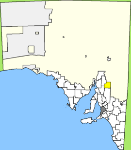 Location of District Council of Peterborough | |||||||||||||||
| Population | 1,638 (LGA 2021)[1] | ||||||||||||||
| Established | 1935 | ||||||||||||||
| Area | 3,020 km2 (1,166.0 sq mi) | ||||||||||||||
| Mayor | Ruth Whittle[2] | ||||||||||||||
| Council seat | Peterborough | ||||||||||||||
| Region | Yorke and Mid North[3] | ||||||||||||||
| State electorate(s) | Stuart[4] | ||||||||||||||
| Federal division(s) | Grey[5] | ||||||||||||||
| Website | District Council of Peterborough | ||||||||||||||
| |||||||||||||||
It was formed on 21 March 1935, when the District Council of Coglin and the District Council of Yongala merged with part of the Corporate Town of Peterborough to create the new council.[7] The remainder of the Corporate Town of Peterborough continued on as an independent municipality surrounded by the District Council until the two were amalgamated in 1997.[8] It still operates out of the heritage-listed 1927 Peterborough Town Hall.[9]
Council edit
| Ward | Councillor | Notes | |
|---|---|---|---|
| Mayor[2] | Ruth Whittle | ||
| Unsubdivided[2] | Michael Burford | ||
| Cassandra Chambers | |||
| Leon Clapp | |||
| Leanne Draper | |||
| Frank Hardbottle | Deputy Mayor | ||
| Graham Mercer | |||
| Scott Mesecke | |||
| Kim Miller | |||
The District Council of Peterborough has a directly elected mayor.[10]
Mayors and Chairmen of the District Council of Peterborough edit
- Ernest Dewar Sawers (1935–1939)[11]
- Thomas Edward Richards (1939-1941)[11]
- Harold Davies (1941-1950)[11]
- Hubert William Lang (1950-1951)[11]
- Leslie Allan McPherson (1951-1954)[11]
- Maxwell Edward Hams (1954–1966)[11]
- Woodrow Eric Douglas Chapman (1966–1967)[11]
- Ronald Naish Bailey (1967-after 1985)[11]
- Ruth Whittle (1991–present)[12]
See also edit
References edit
- ^ Australian Bureau of Statistics (28 June 2022). "Peterborough (Local Government Area)". Australian Census 2021 QuickStats. Retrieved 28 June 2022.
- ^ a b c "Elected Members". District Council of Peterborough. Retrieved 15 February 2015.
- ^ a b "Yorke and Mid North SA Government region" (PDF). The Government of South Australia. Retrieved 10 October 2014.
- ^ "District of Stuart Background Profile". Electoral Commission SA. Retrieved 26 September 2015.
- ^ "Federal electoral division of Grey, boundary gazetted 16 December 2011" (PDF). Australian Electoral Commission. Retrieved 20 August 2015.
- ^ "Location SA Map Viewer". Government of South Australia. Retrieved 15 February 2016.
- ^ Marsden, Susan (2012). "A History of South Australian Councils to 1936" (PDF). Local Government Association of South Australia. p. 11. Retrieved 30 October 2015.
- ^ "Cabinet Documents February 1997". Department of Premier and Cabinet. Archived from the original on 8 December 2015. Retrieved 4 December 2015.
- ^ "Buildings". Peterborough Festival. Archived from the original on 8 December 2015. Retrieved 4 December 2015.
- ^ "Election Results 2014" (PDF). Local Government Association of South Australia. Retrieved 14 February 2016.
- ^ a b c d e f g h Matthews, Penny (1986), South Australia, the civic record, 1836–1986, Wakefield Press, p. 448, ISBN 978-0-949268-82-2
- ^ "Medal (OAM) of the Order of Australia in the General Division" (PDF). Governor-General of Australia. Retrieved 12 November 2016.
External links edit
- Official website
32°58′25″S 138°50′17″E / 32.973510°S 138.838093°E