


Summary
The District Council of Tantanoola was a local government area seated at Tantanoola in South Australia from 1888 to circa 1960.[1]
| District Council of Tantanoola South Australia | |||||||||||||||
|---|---|---|---|---|---|---|---|---|---|---|---|---|---|---|---|
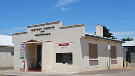 Former chambers of the District Council of Tantantoola | |||||||||||||||
 District Council of Tantanoola | |||||||||||||||
| Coordinates | 37°41′51″S 140°27′20″E / 37.697439°S 140.455519°E | ||||||||||||||
| Established | 1888 | ||||||||||||||
| Council seat | Tantanoola | ||||||||||||||
| |||||||||||||||
History edit
According to South Australian local government historian Sue Marsden "development of South Australia's South East was greatly helped by drainage schemes. Elsewhere in South Australia the Local Board of Main Roads was the precursor to local government, but in the South East it was district drainage boards."[2] The original South-East Drainage District was formed in April 1876.[2] Over the next five years parts were split off to form new drainage districts.[2] The Tantanoola Drainage District was established in 1882 in the vicinity of Tantanoola township.
Six years later in January 1888 the drainage district was declared a council district and expanded to included all of the Hundred of Hindmarsh not already a part of the council area.[3] The District Councils Act 1887 was a statewide legislative push to ensure all settled areas of the state be under local governance. It stated that all existing drainage districts (and the accompanying drainage boards) were to effectively become district councils.[3]
Effective 23 May 1932, Tantanoola annexed a western part of the abolished District Council of Benara and District Council of Mount Gambier West. The Council was subsequently subdivided into Wards named Glencoe East Ward, Glencoe West Ward, Central Ward, and Bridge's Flat Ward.[2][4]
References edit
- ^ "TANTANOOLA COUNCIL WARD BALANCES". The South Eastern Times. No. 4548. South Australia. 19 November 1954. p. 6. Retrieved 9 October 2018 – via National Library of Australia.
- ^ a b c d Marsden, Susan (2012). "LOCAL GOVERNMENT ASSOCIATION OF SOUTH AUSTRALIA: A HISTORY OF SOUTH AUSTRALIAN COUNCILS to 1936" (PDF). Retrieved 22 January 2019.
In 1882, the remainder of the South-East District was absorbed into the new drainage districts of Mayurra, Mount Muirhead (the second) and Tantanoola.
- ^ a b "The District Councils Act (No 419 of 50 and 51 Vic, 1887)". Government of South Australia. 1887.
DISTRICT OF TANTANOOLA.-Comprising the Drainage District of Tantanoola and that portion of the Hundred of Hindmarsh not included in any other district.
- ^ "LOCAL GOVERNMENT AREAS (RE-ARRANGEMENT) ACTS, 1929 AND 1931.—AREAS RE-ARRANGED. (20)" (PDF). South Australian Government Gazette. Government of South Australia. 12 May 1932. p. 847. Retrieved 15 January 2020 – via AustLII.