Doddinghurst

Summary

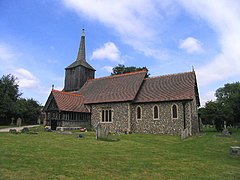
Doddinghurst is a village and civil parish in the Borough of Brentwood, in south Essex. It is 3 miles (5 km) to the north of Brentwood.

Doddinghurst
Doddinghurst is located in Essex
Doddinghurst
Doddinghurst
Location within Essex
Population2,832 (2011 census)[1]
OS grid referenceTQ593986
Civil parish
  • Doddinghurst [2]
District
Shire county
Region
CountryEngland
Sovereign stateUnited Kingdom
Post townBRENTWOOD
Postcode districtCM15
Dialling code01277
PoliceEssex
FireEssex
AmbulanceEast of England
UK Parliament
List of places
UK
England
Essex

51°39′49″N 0°18′15″E / 51.6635°N 0.3043°E / 51.6635; 0.3043

History edit

The village was recorded in the Domesday Book as Doddenhenc, an Anglo-Saxon name meaning "the wood of Dudda or of his people".[3] The modern form of the village name was established by the 13th century.[4]

The Church, All Saints, and its associated Priest House are charming historical buildings, and are clearly visible on Church Lane. The Church has a 13th-century nave and south doorway with other aspects added or improved during the 15th and 17th centuries with a major restoration in 1886 including the rebuilding of the chancel. The Marriage Register in the church is dated back

The village today edit

The village is based around a pair of main roads, Doddinghurst Road (from Brentwood to Doddinghurst) and Church Lane (forming part of an overall road circling from Kelvedon Hatch which also runs through Hook End and Wyatts Green) intersecting at the north end of the village. The village's amenities include a pair of closely linked schools (Doddinghurst Infant School and Doddinghurst CofE Junior School), All Saints Church dating back to the 13th century, the Kervan Kitchen restaurant (formerly the Willow pub) and a village hall. There is a scout hut (for the 1st Doddinghurst Scout Troup) located towards the back of the playing fields in the north of the village.

There is a small group of shops near the village hall and church at the north end of the village (including a newsagent, a barber, a beauty salon, a pharmacy and an off-licence), while on Church Lane there is an estate agent, a barbers and a fish bar. Half a mile away (towards the geographical centre of the village), is a Post Office.

The Village Hall is opposite All Saints Church in Church Lane. Adjoining the Village Hall are the office and committee rooms of Doddinghurst Parish Council who own and manage the major amenities of the Village, which include children's play areas and spaces such as Peartree Field. In addition to recreational space the Parish Council manage the Burial Ground at the rear of All Saints Church and Garden Allotments off Mountnessing Lane. Behind the Village Hall there are several large playing fields where Village events are held every two years in aid of local charitable organizations and other celebrations such as Village Fun Days that have been organized and funded by the Parish Council. The local Football Club make regular use of the Parish Council playing fields and the Village Hall playing field.

The village has a new Doctors' surgery located near Deal Tree Corner with four or five doctors and several nurses that also supports the surrounding villages. The village is set in a rural farming environment with pleasant fields and small deciduous woods, many of which are connected by a network of gently undulating public footpaths. The River Wid runs through the village, along with a number of its tributaries.

Much of the village has been built or redeveloped from 1950 onward although it remains a largely rural community with much of the area given over to arable agriculture.[5]

On 17 September 2007 Doddinghurst Parish Council received Quality Status under the UK's Department for Environment, Food and Rural Affairs (DEFRA) scheme designed to enhance the relationship between the local community and local governance.[6] In November 2009 the Parish Council became eligible, and adopted, the Power of Well-Being which significantly improves its ability to spend money on matters benefitting either the social, or economic or environmental benefit of the community.

The village has significant areas of land for recreational use other than the playing field behind the Village Hall, including the Peartree Recreational Field (opposite the Post Office), while the junior school has a large field and woodland attached.

Notable people edit

References edit

  1. ^ "Civil Parish population 2011". Neighbourhood Statistics. Office for National Statistics. Retrieved 2 September 2016.
  2. ^ https://www.essexinfo.net/doddinghurst-pc/
  3. ^ Domesday studies: papers read at the Novocentenary Conference of the Royal ... The Boydell Press. 15 February 2012. ISBN 9780851152639. Retrieved 15 February 2012.
  4. ^ Brentwood Official Guide - 2001
  5. ^ Brentwood Guide
  6. ^ http://www.doddinghurstpc.co.uk/%7CDoddinghurst Archived January 20, 2008, at the Wayback Machine Parish Council Website

External links edit

  • Doddinghurst Donkey Derby
  • Doddinghurst Parish Council
  • Doddinghurst Doctors' Surgery
  • Doddinghurst CofE Junior School
  • Doddinghurst Olympic Football Club
  • Doddinghurst Community Website
  • Doddinghurst Road Community Church
    • Footpaths