


Summary
54°45′32″N 5°00′26″W / 54.758993°N 5.007268°W
 Doon Castle Broch | |
 Doon Castle Broch, Scotland | |
| Location | Dumfries and Galloway |
|---|---|
| Coordinates | 54°45′35″N 5°00′21″W / 54.759777°N 5.005741°W |
| Type | Broch |
| History | |
| Periods | Iron Age |
| Designated | 24 October 1924 |
| Reference no. | SM1970 |
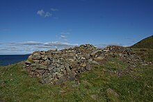
Doon Castle Broch is an iron-age broch located in Dumfries and Galloway, Scotland (grid reference NX 06702 44683).
Location edit
The Broch is located on the Rhins of Galloway in Dumfries and Galloway.[1]
History edit
The broch was first recorded by archaeologists in 1912 by RCAHMS in their 'Fourth Report and Inventory of Monuments and Constructions in Galloway'. It has since been mentioned in several other publications but has yet to have been excavated.[1]
Description edit
Doon Castle broch is located on the south side of Ardwell Point, which projects out into the North Channel. An early description mentions that the broch is separated from the main land by a wall and natural gully (6 meters across and 2.3 meters deep) crossed by a man-made causeway (1.9 meters wide and 0.9 meters high).[2]
The remains of the broch are reasonably preserved, showing that the structure is 9 meters in diameter with walls 3–4 meters in thickness. On the northeast side the wall is preserved up to 1.8 meters in height. This broch had two entrances; one on the north-northeast side (which is blocked by fallen stones) and a second in the south side. These two entrances coincide with land and sea approaches. There is a chamber to the east, with a possible second chamber to the west. The extant remains of the chamber to the east consist of the sides of the entrance (measuring 0.8 meters at the mouth to 1.2 meters closer to the inner wall face). There is far less known about the possible west chamber.
Between Doon Castle broch and the northern end of the point there are further archaeological remains, including a wall approximately 2.6 meters thick. This wall appears to enclose an area 14 meters (E-W) by 10 meters (N-S). This outer structure was likely entered in the north-northeast wall, which is situated opposite the manmade causeway.[3]
Archaeological Finds edit
Doon Castle Broch has not been excavated, with survey only revealing rubble in the interior.
Images edit
-
 Doon Castle Broch at Ardwell Bay
 -
 Doon Castle Broch Interior
 -
 Doon Castle Broch
 -
 Doon Castle Broch


References edit
External links edit
![]() Media related to Doon Castle Broch at Wikimedia Commons
Media related to Doon Castle Broch at Wikimedia Commons
- Historic Environment Scotland. "Doon Castle, Ardwell Point (60487)". Canmore.
- The Modern Antiquarian, Doon Castle (Broch)