


Summary
Doudleby (German: Teindles) is a municipality and village in České Budějovice District in the South Bohemian Region of the Czech Republic. It has about 500 inhabitants.
Doudleby | |
|---|---|
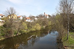 Doudleby above the Malše River | |
 Flag  Coat of arms | |
 Doudleby Location in the Czech Republic | |
| Coordinates: 48°53′37″N 14°30′5″E / 48.89361°N 14.50139°E | |
| Country | |
| Region | South Bohemian |
| District | České Budějovice |
| First mentioned | 981 |
| Area | |
| • Total | 5.86 km2 (2.26 sq mi) |
| Elevation | 425 m (1,394 ft) |
| Population (2023-01-01)[1] | |
| • Total | 473 |
| • Density | 81/km2 (210/sq mi) |
| Time zone | UTC+1 (CET) |
| • Summer (DST) | UTC+2 (CEST) |
| Postal code | 370 07 |
| Website | www |
Administrative parts edit

The village of Straňany is an administrative part of Doudleby.
Etymology edit
The name is derived from the Slavic tribe of Dulebes, who lived there in the mid-10th century.[2]
Geography edit
Doudleby is located about 8 kilometres (5 mi) south of České Budějovice. It lies in the Gratzen Foothills. The village of Doudleby lies in a meander of the Malše River and the village of Straňany lies on the opposite bank.
History edit

The first written mention of Doudleby is in the Chronica Boemorum chronicle, where there is a mention of a gord related to the year 981. According to the chronicle, this fortified settlement was part of the early medieval Slavník's territory, but according to today's historians, it was a Přemyslid gord. Doudleby was then located on at the crossroads of two important trade routes and served as the centre of the region. After the founding of the city of České Budějovice in 1265, the importance of Doudleby quickly declined.[2]
Demographics edit
|
|
| ||||||||||||||||||||||||||||||||||||||||||||||||||||||
| Source: Censuses[3][4] | ||||||||||||||||||||||||||||||||||||||||||||||||||||||||
Transport edit
There are no railways or major roads passing through the municipality.
Sights edit
The Church of Saint Vincent was first mentioned in 1143. The oldest preserved parts are the Gothic sacristy and chancel from the 14th century. The nave was added at the end of the 15th century. In 1708–1709, the church was rebuilt in the Baroque style, and the tower was added.[2]
References edit
- ^ "Population of Municipalities – 1 January 2023". Czech Statistical Office. 2023-05-23.
- ^ a b c "Z historie Doudleb" (in Czech). Obec Doudleby. Retrieved 2022-06-06.
- ^ "Historický lexikon obcí České republiky 1869–2011 – Okres České Budějovice" (in Czech). Czech Statistical Office. 2015-12-21. pp. 5–6.
- ^ "Population Census 2021: Population by sex". Public Database. Czech Statistical Office. 2021-03-27.
External links edit
- Official website