
KNOWPIA
WELCOME TO KNOWPIA

Drimmelen 
Summary
Drimmelen (Dutch pronunciation: [ˈdrɪmələ(n)] ⓘ) is a municipality and a town in the southern Netherlands, in the province North Brabant.
Drimmelen | |
|---|---|
 Aerial photo of Made | |
 Flag | |
 Location in North Brabant | |
| Coordinates: 51°41′N 4°48′E / 51.683°N 4.800°E | |
| Country | Netherlands |
| Province | North Brabant |
| Government | |
| • Body | Municipal council |
| • Mayor | Gert de Kok (PvdA) |
| Area | |
| • Total | 119.43 km2 (46.11 sq mi) |
| • Land | 95.18 km2 (36.75 sq mi) |
| • Water | 24.25 km2 (9.36 sq mi) |
| Elevation | 3 m (10 ft) |
| Population (January 2021)[4] | |
| • Total | 27,325 |
| • Density | 287/km2 (740/sq mi) |
| Time zone | UTC+1 (CET) |
| • Summer (DST) | UTC+2 (CEST) |
| Postcode | 4844–4845, 4920–4927 |
| Area code | 0162 |
| Website | www |
A large portion of the Biesbosch National Park is part of this municipality.
Population centres edit
Towns:
- Made (population: 11,710)
- Terheijden (6,410)
- Lage Zwaluwe (4,060)
- Wagenberg (2,250)
- Hooge Zwaluwe (1,670)
- Drimmelen (570)
Hamlets (population data concerning these hamlets are included in the population data of the towns near which they are located):
- Blauwe Sluis
- Oud-Drimmelen
- Helkant
Topography edit

Dutch Topographic map of the municipality of Drimmelen, June 2015.
Transportation edit
The Lage Zwaluwe railway station is situated on the Breda–Rotterdam railway and the railway to Roosendaal.
Notable people edit

- Godfried Schalcken (1643 in Made – 1706) a Dutch genre and portrait painter
- Pieter Rudolph Kleijn (1785 in Hooge Zwaluwe – 1816) a 19th-century landscape painter
- Petrus van Schendel (1806 in Terheijden - 1870) a Dutch-Belgian Romantic style genre painter
- Johannes Gijsbert Vogel (1828 in Hooge Zwaluwe – 1915) a Dutch landscape painter
- Antal van den Bosch (born 1969 in Made) a Dutch-language researcher and former academic
Sport edit
- Kees Pellenaars (1913 in Terheijden – 1988) a Dutch road cyclist and coach
- Antoon van Schendel (1918 in Lage Zwaluwe — 1990) a Dutch professional road bicycle racer.
- Wim Hofkens (born 1958 in Made) a former football player with 474 club caps
- Gianni Romme (born 1973 in Lage Zwaluwe) a Dutch marathon runner and a former long track speed skater, won two gold medals at the 1998 Winter Olympics
- Hans Horrevoets (born 1974 in Made – 2006) a Dutch sea sailor
- Tim Lips (born 1985 in Made) a Dutch eventer, competed at the 2008 and the 2012 Summer Olympics
- Pieter Braun (born 1993 in Terheijden) is a Dutch decathlon athlete, competed at the 2016 Summer Olympics
Gallery edit
-
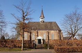 Made, reformed church
 -
 Jachthaven, Drimmelen
 -
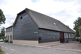 Woonhuis met bedrijfsgedeelte, Bloemendaalse Zeedijk 40, Blauwe Sluis
 -
 Zilvermeeuw, Drimmelen


References edit
- ^ "Collegeleden" [Board members] (in Dutch). Gemeente Drimmelen. Retrieved 10 May 2014.
- ^ "Kerncijfers wijken en buurten 2020" [Key figures for neighbourhoods 2020]. StatLine (in Dutch). CBS. 24 July 2020. Retrieved 19 September 2020.
- ^ "Postcodetool for 4921BV". Actueel Hoogtebestand Nederland (in Dutch). Het Waterschapshuis. Retrieved 11 May 2014.
- ^ "Bevolkingsontwikkeling; regio per maand" [Population growth; regions per month]. CBS Statline (in Dutch). CBS. 1 January 2021. Retrieved 2 January 2022.
External links edit
Wikimedia Commons has media related to Drimmelen.
- Official Website