
KNOWPIA
WELCOME TO KNOWPIA

Drocourt, Pas-de-Calais 
Summary
Drocourt (French pronunciation: [dʁɔkuʁ]) is a commune in the Pas-de-Calais department in the Hauts-de-France region of France.[3]
Drocourt | |
|---|---|
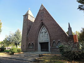 The church of Drocourt | |
 Coat of arms | |
Location of Drocourt .mw-parser-output .locmap .od{position:absolute}.mw-parser-output .locmap .id{position:absolute;line-height:0}.mw-parser-output .locmap .l0{font-size:0;position:absolute}.mw-parser-output .locmap .pv{line-height:110%;position:absolute;text-align:center}.mw-parser-output .locmap .pl{line-height:110%;position:absolute;top:-0.75em;text-align:right}.mw-parser-output .locmap .pr{line-height:110%;position:absolute;top:-0.75em;text-align:left}.mw-parser-output .locmap .pv>div{display:inline;padding:1px}.mw-parser-output .locmap .pl>div{display:inline;padding:1px;float:right}.mw-parser-output .locmap .pr>div{display:inline;padding:1px;float:left}html.skin-theme-clientpref-night .mw-parser-output .od,html.skin-theme-clientpref-night .mw-parser-output .od .pv>div,html.skin-theme-clientpref-night .mw-parser-output .od .pl>div,html.skin-theme-clientpref-night .mw-parser-output .od .pr>div{background:#000;color:#fff}html.skin-theme-clientpref-night .mw-parser-output .locmap{filter:grayscale(0.6)}@media(prefers-color-scheme:dark){html.skin-theme-clientpref-os .mw-parser-output .locmap{filter:grayscale(0.6)}html.skin-theme-clientpref-os .mw-parser-output .od,html.skin-theme-clientpref-os .mw-parser-output .od .pv>div,html.skin-theme-clientpref-os .mw-parser-output .od .pl>div,html.skin-theme-clientpref-os .mw-parser-output .od .pr>div{background:#000;color:#fff}}  Drocourt  Drocourt | |
| Coordinates: 50°23′31″N 2°55′39″E / 50.3919°N 2.9275°E | |
| Country | France |
| Region | Hauts-de-France |
| Department | Pas-de-Calais |
| Arrondissement | Lens |
| Canton | Hénin-Beaumont-2 |
| Intercommunality | CA Hénin-Carvin |
| Government | |
| • Mayor (2020–2026) | Bernard Czerwinski[1] |
| Area 1 | 3.4 km2 (1.3 sq mi) |
| Population (2021)[2] | 2,943 |
| • Density | 870/km2 (2,200/sq mi) |
| Time zone | UTC+01:00 (CET) |
| • Summer (DST) | UTC+02:00 (CEST) |
| INSEE/Postal code | 62277 /62320 |
| Elevation | 39–68 m (128–223 ft) (avg. 41 m or 135 ft) |
| 1 French Land Register data, which excludes lakes, ponds, glaciers > 1 km2 (0.386 sq mi or 247 acres) and river estuaries. | |
Geography edit
An ex-coalmining commune, now a light industrial and farming town, situated some 6 miles (9.7 km) southeast of Lens, at the junction of the D919, D40 and D47 roads.
Population edit
| Year | Pop. | ±% p.a. |
|---|---|---|
| 1968 | 2,361 | — |
| 1975 | 3,035 | +3.65% |
| 1982 | 3,458 | +1.88% |
| 1990 | 3,341 | −0.43% |
| 1999 | 3,104 | −0.81% |
| 2007 | 2,989 | −0.47% |
| 2012 | 2,978 | −0.07% |
| 2017 | 2,936 | −0.28% |
| Source: INSEE[4] | ||
Places of interest edit
- The churches of St.Leger and of St. Barbe, both dating from the twentieth century.
International relations edit
See also edit
References edit
- ^ "Répertoire national des élus: les maires". data.gouv.fr, Plateforme ouverte des données publiques françaises (in French). 9 August 2021.
- ^ "Populations légales 2021". The National Institute of Statistics and Economic Studies. 28 December 2023.
- ^ INSEE commune file
- ^ Population en historique depuis 1968, INSEE
External links edit
Wikimedia Commons has media related to Drocourt (Pas-de-Calais).
- Agglo Hénin-Carvin website (in French)