
KNOWPIA
WELCOME TO KNOWPIA

Druelle Balsac 
Summary
Druelle Balsac (French pronunciation: [dʁyɛl balsak]; Occitan: Druèla e Balsac) is a commune in the department of Aveyron, southern France. The municipality was established on 1 January 2017 by merger of the former communes of Druelle (the seat) and Balsac.[2]
Druelle Balsac | |
|---|---|
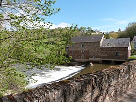 The mill on the Aveyron river, in the hamlet of Les Planques | |
Location of Druelle Balsac .mw-parser-output .locmap .od{position:absolute}.mw-parser-output .locmap .id{position:absolute;line-height:0}.mw-parser-output .locmap .l0{font-size:0;position:absolute}.mw-parser-output .locmap .pv{line-height:110%;position:absolute;text-align:center}.mw-parser-output .locmap .pl{line-height:110%;position:absolute;top:-0.75em;text-align:right}.mw-parser-output .locmap .pr{line-height:110%;position:absolute;top:-0.75em;text-align:left}.mw-parser-output .locmap .pv>div{display:inline;padding:1px}.mw-parser-output .locmap .pl>div{display:inline;padding:1px;float:right}.mw-parser-output .locmap .pr>div{display:inline;padding:1px;float:left}html.skin-theme-clientpref-night .mw-parser-output .od,html.skin-theme-clientpref-night .mw-parser-output .od .pv>div,html.skin-theme-clientpref-night .mw-parser-output .od .pl>div,html.skin-theme-clientpref-night .mw-parser-output .od .pr>div{background:#000;color:#fff}html.skin-theme-clientpref-night .mw-parser-output .locmap{filter:grayscale(0.6)}@media(prefers-color-scheme:dark){html.skin-theme-clientpref-os .mw-parser-output .locmap{filter:grayscale(0.6)}html.skin-theme-clientpref-os .mw-parser-output .od,html.skin-theme-clientpref-os .mw-parser-output .od .pv>div,html.skin-theme-clientpref-os .mw-parser-output .od .pl>div,html.skin-theme-clientpref-os .mw-parser-output .od .pr>div{background:#000;color:#fff}}  Druelle Balsac  Druelle Balsac | |
| Coordinates: 44°20′42″N 2°29′35″E / 44.345°N 2.493°E | |
| Country | France |
| Region | Occitania |
| Department | Aveyron |
| Arrondissement | Rodez |
| Canton | Vallon |
| Intercommunality | Rodez Agglomération |
| Area 1 | 51.25 km2 (19.79 sq mi) |
| Population (2021)[1] | 3,188 |
| • Density | 62/km2 (160/sq mi) |
| Time zone | UTC+01:00 (CET) |
| • Summer (DST) | UTC+02:00 (CEST) |
| INSEE/Postal code | 12090 /12000, 12510 |
| 1 French Land Register data, which excludes lakes, ponds, glaciers > 1 km2 (0.386 sq mi or 247 acres) and river estuaries. | |
Population edit
| Year | Pop. | ±% p.a. |
|---|---|---|
| 1968 | 1,233 | — |
| 1975 | 1,305 | +0.81% |
| 1982 | 1,628 | +3.21% |
| 1990 | 1,831 | +1.48% |
| 1999 | 2,186 | +1.99% |
| 2007 | 2,511 | +1.75% |
| 2012 | 2,634 | +0.96% |
| 2017 | 3,143 | +3.60% |
| Source: INSEE[3] | ||
See also edit
References edit
Wikimedia Commons has media related to Druelle Balsac.
- ^ "Populations légales 2021". The National Institute of Statistics and Economic Studies. 28 December 2023.
- ^ Arrêté préfectoral 6 September 2016 (in French)
- ^ Population en historique depuis 1968, INSEE