
KNOWPIA
WELCOME TO KNOWPIA

Drusenheim 
Summary
Drusenheim (French pronunciation: [dʁyzənaim] ⓘ or [dʁuzənaim][3]) is a commune in the Bas-Rhin département in Grand Est in north-eastern France,[4] situated on the bank of the Rhine.
Drusenheim | |
|---|---|
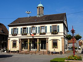 The town hall in Drusenheim | |
 Coat of arms | |
Location of Drusenheim .mw-parser-output .locmap .od{position:absolute}.mw-parser-output .locmap .id{position:absolute;line-height:0}.mw-parser-output .locmap .l0{font-size:0;position:absolute}.mw-parser-output .locmap .pv{line-height:110%;position:absolute;text-align:center}.mw-parser-output .locmap .pl{line-height:110%;position:absolute;top:-0.75em;text-align:right}.mw-parser-output .locmap .pr{line-height:110%;position:absolute;top:-0.75em;text-align:left}.mw-parser-output .locmap .pv>div{display:inline;padding:1px}.mw-parser-output .locmap .pl>div{display:inline;padding:1px;float:right}.mw-parser-output .locmap .pr>div{display:inline;padding:1px;float:left}html.skin-theme-clientpref-night .mw-parser-output .od,html.skin-theme-clientpref-night .mw-parser-output .od .pv>div,html.skin-theme-clientpref-night .mw-parser-output .od .pl>div,html.skin-theme-clientpref-night .mw-parser-output .od .pr>div{background:#fff;color:#000}html.skin-theme-clientpref-night .mw-parser-output .locmap{filter:grayscale(0.6)}@media(prefers-color-scheme:dark){html.skin-theme-clientpref-os .mw-parser-output .locmap{filter:grayscale(0.6)}html.skin-theme-clientpref-os .mw-parser-output .od,html.skin-theme-clientpref-os .mw-parser-output .od .pv>div,html.skin-theme-clientpref-os .mw-parser-output .od .pl>div,html.skin-theme-clientpref-os .mw-parser-output .od .pr>div{background:white;color:#000}}  Drusenheim  Drusenheim | |
| Coordinates: 48°45′46″N 7°57′09″E / 48.7628°N 7.9525°E | |
| Country | France |
| Region | Grand Est |
| Department | Bas-Rhin |
| Arrondissement | Haguenau-Wissembourg |
| Canton | Bischwiller |
| Government | |
| • Mayor (2020–2026) | Jacky Keller[1] |
| Area 1 | 15.73 km2 (6.07 sq mi) |
| Population (2021)[2] | 5,292 |
| • Density | 340/km2 (870/sq mi) |
| Time zone | UTC+01:00 (CET) |
| • Summer (DST) | UTC+02:00 (CEST) |
| INSEE/Postal code | 67106 /67410 |
| Elevation | 119–128 m (390–420 ft) |
| 1 French Land Register data, which excludes lakes, ponds, glaciers > 1 km2 (0.386 sq mi or 247 acres) and river estuaries. | |
History edit
Drusenheim was fortified by the military architect Jean Maximilien Welsch in 1705.
Population edit
| Year | Pop. | ±% p.a. |
|---|---|---|
| 1968 | 3,335 | — |
| 1975 | 3,827 | +1.99% |
| 1982 | 4,309 | +1.71% |
| 1990 | 4,363 | +0.16% |
| 1999 | 4,723 | +0.88% |
| 2007 | 5,028 | +0.79% |
| 2012 | 5,089 | +0.24% |
| 2017 | 5,154 | +0.25% |
| Source: INSEE[5] | ||
Notable people edit
- Roland Wagner (born 1955), former football international
See also edit
References edit
- ^ "Répertoire national des élus: les maires". data.gouv.fr, Plateforme ouverte des données publiques françaises (in French). 2 December 2020.
- ^ "Populations légales 2021". The National Institute of Statistics and Economic Studies. 28 December 2023.
- ^ "Localisation et prononciation des noms de lieux d'Alsace commençant par C ou D". elsasser.free.fr. Archived from the original on 2020-08-20. Retrieved 2019-03-24.
- ^ INSEE commune file
- ^ Population en historique depuis 1968, INSEE
Wikimedia Commons has media related to Drusenheim.