
-
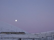 The town in a winter morning
 -
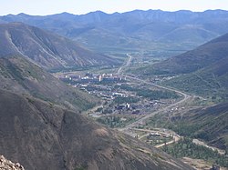
 Gallery 22 of the Dukat Mine
 -
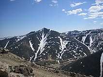 View from the Dukat Mine

KNOWPIA
WELCOME TO KNOWPIA
Dukat, Russia 
Summary
Dukat (Russian: Дукат) is an urban locality (an urban-type settlement) in the Omsukchansky District of Magadan Oblast, Russia, located 595 kilometers (370 mi) north of Magadan. Population: 1,351 (2010 Census);[1] 1,287 (2002 Census);[6] 6,945 (1989 Census).[7]
Dukat
Дукат | |
|---|---|
 View of Dukat | |
Location of Dukat .mw-parser-output .locmap .od{position:absolute}.mw-parser-output .locmap .id{position:absolute;line-height:0}.mw-parser-output .locmap .l0{font-size:0;position:absolute}.mw-parser-output .locmap .pv{line-height:110%;position:absolute;text-align:center}.mw-parser-output .locmap .pl{line-height:110%;position:absolute;top:-0.75em;text-align:right}.mw-parser-output .locmap .pr{line-height:110%;position:absolute;top:-0.75em;text-align:left}.mw-parser-output .locmap .pv>div{display:inline;padding:1px}.mw-parser-output .locmap .pl>div{display:inline;padding:1px;float:right}.mw-parser-output .locmap .pr>div{display:inline;padding:1px;float:left}html.skin-theme-clientpref-night .mw-parser-output .od,html.skin-theme-clientpref-night .mw-parser-output .od .pv>div,html.skin-theme-clientpref-night .mw-parser-output .od .pl>div,html.skin-theme-clientpref-night .mw-parser-output .od .pr>div{background:#000;color:#fff}html.skin-theme-clientpref-night .mw-parser-output .locmap{filter:grayscale(0.6)}@media(prefers-color-scheme:dark){html.skin-theme-clientpref-os .mw-parser-output .locmap{filter:grayscale(0.6)}html.skin-theme-clientpref-os .mw-parser-output .od,html.skin-theme-clientpref-os .mw-parser-output .od .pv>div,html.skin-theme-clientpref-os .mw-parser-output .od .pl>div,html.skin-theme-clientpref-os .mw-parser-output .od .pr>div{background:#000;color:#fff}}  Dukat Location of Dukat 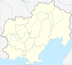 Dukat Dukat (Magadan Oblast) | |
| Coordinates: 62°34′28.4″N 155°23′08.0″E / 62.574556°N 155.385556°E | |
| Country | Russia |
| Federal subject | Magadan Oblast |
| Administrative district | Omsukchansky District |
| Elevation | 857 m (2,812 ft) |
| Population | |
| • Total | 1,351 |
| • Estimate (2018)[2] | 1,292 (−4.4%) |
| Time zone | UTC+11 (MSK+8 |
| Postal code(s)[4] | 686417 |
| OKTMO ID | 44704000056 |
History edit
In the mid of the 1960s, geologists from Omsukchan discovered a rich ore deposit of silver; and named the settlement of Dukat, founded in 1968, after the ducat, an old trade coin used in Europe. The status of urban-type settlement was assigned by the decision of the Magadan Regional Executive Committee of February 19, 1976.
Geography edit
Dukat is located in a valley between two mountains of the Omsukchan Range, Kolyma Highlands, 27 km west of Omsukchan, the raion's seat and the nearest populated place. It is 30 km from Omsukchan Airport and 45 from the ghost town of Galimy.
Economy edit
The town is known for its gold mine, one of the largest in Russia,[8] located few km west of the town.
Gallery edit


See also edit
References edit
- ^ a b Russian Federal State Statistics Service (2011). Всероссийская перепись населения 2010 года. Том 1 [2010 All-Russian Population Census, vol. 1]. Всероссийская перепись населения 2010 года [2010 All-Russia Population Census] (in Russian). Federal State Statistics Service.
- ^ "26. Численность постоянного населения Российской Федерации по муниципальным образованиям на 1 января 2018 года". Federal State Statistics Service. Retrieved 23 January 2019.
- ^ "Об исчислении времени". Официальный интернет-портал правовой информации (in Russian). 3 June 2011. Retrieved 19 January 2019.
- ^ Почта России. Информационно-вычислительный центр ОАСУ РПО. (Russian Post). Поиск объектов почтовой связи (Postal Objects Search) (in Russian)
- ^ Office of the Federal State Statistics Service for Khabarovsk Krai, Magadan Oblast, Jewish Autonomous Oblast and Chukotka Autonomous Okrug. Численность населения Магаданская область по муниципальным образованиям на 1 января 2017 года Archived 2017-12-22 at the Wayback Machine (in Russian)
- ^ Russian Federal State Statistics Service (21 May 2004). Численность населения России, субъектов Российской Федерации в составе федеральных округов, районов, городских поселений, сельских населённых пунктов – районных центров и сельских населённых пунктов с населением 3 тысячи и более человек [Population of Russia, Its Federal Districts, Federal Subjects, Districts, Urban Localities, Rural Localities—Administrative Centers, and Rural Localities with Population of Over 3,000] (XLS). Всероссийская перепись населения 2002 года [All-Russia Population Census of 2002] (in Russian).
- ^ Всесоюзная перепись населения 1989 г. Численность наличного населения союзных и автономных республик, автономных областей и округов, краёв, областей, районов, городских поселений и сёл-райцентров [All Union Population Census of 1989: Present Population of Union and Autonomous Republics, Autonomous Oblasts and Okrugs, Krais, Oblasts, Districts, Urban Settlements, and Villages Serving as District Administrative Centers]. Всесоюзная перепись населения 1989 года [All-Union Population Census of 1989] (in Russian). Институт демографии Национального исследовательского университета: Высшая школа экономики [Institute of Demography at the National Research University: Higher School of Economics]. 1989 – via Demoscope Weekly.
- ^ "Dukat Gold Mine". polymetalinternational.com. 2013. Retrieved 2013-07-06.
External links edit
Wikimedia Commons has media related to Dukat.
- Dukat on geographic.org
- Dukat weather on worldweatheronline.com