


Summary
Dunagiri (7,066 m) is one of the high peaks of the Chamoli District Himalayas in the northern Indian state of Uttarakhand. It lies at the northwest corner of the Sanctuary Wall, a ring of peaks surrounding Nanda Devi and enclosing the Nanda Devi Sanctuary.
| Dunagiri | |
|---|---|
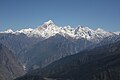
 Dunagiri from the Kuari Pass | |
| Highest point | |
| Elevation | 7,066 m (23,182 ft) |
| Prominence | c. 1,200 m (3,900 ft)[1] |
| Coordinates | 30°31′57″N 79°50′02″E / 30.53250°N 79.83389°E |
| Geography | |
 Dunagiri Location in Uttarakhand, India | |
| Location | Uttarakhand, India |
| Parent range | Nanda Devi Group, Garhwal Himalayas |
| Climbing | |
| First ascent | 5 July 1939 by André Roch, F. Steuri, D. Zogg[2] |
| Easiest route | southwest ridge: rock/snow/ice climb |
In Hindu mythology edit
According to Ramayana, Sanjeevani is a magical herb that has the power to cure serious nervous system problems. It was believed that medicines prepared from this herb could revive someone when death was almost certain. The herb is mentioned in the Ramayana when Ravana's son Indrajit (Meghnada) hurls a powerful weapon at Lakshmana. Lakshmana is badly wounded and is nearly killed. Hanuman was called upon to fetch this herb from Mount Dronagiri (Mahodaya) or the Gandhamardhan hills, far to the north of the Vindhyas on the slopes of the Himalayas. The mountain of herbs is identified as the Valley of Flowers near Badri in Uttarakhand on the slopes of the Himalayas. It is sometimes called Gandhamardan, and at other times Dronagiri. Upon reaching Dronagiri Parvata or Gandhamardan, Hanuman could not identify the herb and lifted the whole mountain and brought it to the battlefield.[3]
History edit
Dunagiri was first climbed on 5 July 1939[4] by the Swiss climbers André Roch, F. Steuri and D. Zogg, via the southwest ridge. In 1975, Joe Tasker and Dick Renshaw climbed a particularly difficult route on the southeast buttress in a significant milestone for alpine-style climbing.[5] In 1978 the first Australian Himalayan expedition by the Australian National University Mountaineering Club made the fourth ascent via the south-west ridge.[6] Lincoln Hall and Tim Macartney-Snape made the final summit attempt with Macartney-Snape successfully summiting.
Gallery edit
-
 Dunagiri peak from Kartik Swami Temple
 -
 Dunagiri from Kuari Pass
 -
 Dunagiri from Kuari Pass


References edit
- ^ This is an approximate figure, based on the 1:150,000 scale topographic map Garhwal-Himalaya-Ost, Swiss Foundation for Alpine Research.
- ^ Jill Neate (1989). High Asia: An Illustrated History of the 7000 Metre Peaks. ISBN 0-89886-238-8.
- ^ "Peaks that became temples". The Hindu. 16 March 2017. Retrieved 1 December 2020.
- ^ Some sources say 1947.
- ^ Andy Fanshawe and Stephen Venables, Himalaya Alpine-Style, Hodder and Stoughton, 1995, ISBN 0-340-64931-3
- ^ Steffen, Will (2010). Himalayan Dreaming: Australian mountaineering in the great ranges of Asia 1922-1990. Canberra: ANU E Press. p. 593. ISBN 978-1-921666-16-2.