


Summary
Durgapur subdivision is an administrative subdivision of the Paschim Bardhaman district in the state of West Bengal, India.
Durgapur subdivision | |
|---|---|
Subdivision | |
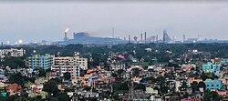 Durgapur Steel Plant | |
 | |
| Coordinates: 23°29′N 87°19′E / 23.48°N 87.32°E | |
| Country | India |
| State | West Bengal |
| District | Paschim Bardhaman |
| Headquarters | Durgapur |
| Area | |
| • Total | 771.28 km2 (297.79 sq mi) |
| Population | |
| • Total | 1,209,372 |
| • Density | 1,600/km2 (4,100/sq mi) |
| Languages | |
| • Official | Bengali, English |
| Time zone | UTC+5:30 (IST) |
| ISO 3166 code | ISO 3166-2:IN |
| Website | http://www.sdodurgapur.org/ |
Overview edit
The rocky undulating topography with laterite soil found in the western part of the district extends to the western part of Durgapur subdivision. For ages the area was heavily forested and infested with plunderers and marauders. The discovery of coal in the 18th century led to industrialisation of the western part of the subdivision. Most of the forests in the western part of the subdivision have been cleared but the eastern part remained thickly forested till more recent times and some are still there. The eastern part of the subdivision gradually slopes down to the rice plains of Bengal.[1][2]

Subdivisions edit
Paschim Bardhaman district is divided into the following two administrative subdivisions:[3][4]

| Subdivision | Headquarters | Area km2 |
Population (2011) |
Rural Population % (2011) |
Urban Population % (2011) |
|---|---|---|---|---|---|
| Asansol Sadar | Asansol | 831.89 | 1,672,659 | 16.67 | 83.33 |
| Durgapur | Durgapur | 771.28 | 1,209,372 | 20.78 | 79.22 |
| Paschim Bardhaman district | Asansol | 1,603.17 | 2,882,031 | 18.39 | 81.61 |
Note:Before bifurcation of the erstwhile Bardhaman district Galsi I was in Durgapur subdivision, but after bifurcation it is in Bardhman Sadar North subdivision.
In the maps placed below, all places marked and linked in the full screen maps.


3miles
Sonpur Bazari
Area Office
Area Office
Area Office
MC: Municipal Corporation, CT: census town, R: rural administrative centre
Owing to space constraints in the small map, the actual locations in a larger map may vary slightly


3miles
Projects
Limited
Steels
Plant
Steel
Plant
Barrage
Islam Airport
Area Office
MC: Municipal Corporation, CT: census town, R: rural centre, A: airport, B: barrage
Owing to space constraints in the small map, the actual locations in a larger map may vary slightly
Administrative units edit
Durgapur subdivision has 6 police stations, 4 community development blocks, 4 panchayat samitis, 27 gram panchayats, 171 mouzas, 151 inhabited villages, 1 municipal corporation and 38 census towns+1 (partly). The single municipal corporation is at Durgapur. The census towns are: Siduli, Khandra, Chak Bankola, Ukhra, Mahira, Dakshin Khanda, Parashkol, Kajora, Harishpur, Palashban, Dignala, Andal (gram), Ondal, Baska, Bilpahari, Ramnagar, Dalurband, Baidyanathpur, Mahal, Konardihi, Nabgram, Sankarpur, Haripur, Chhora, Bahula, Mandarbani, Banagram, Sirsha, Nabaghanapur, Sarpi, Ichhapur, Arra, Gopalpur, Bamunara, Amlajora, Kanksa, Debipur, Prayagpur and Kendra Khottamdi (part). The subdivision has its headquarters at Durgapur.[5][6]
Demographics edit
As per the 2011 Census of India data Durgapur subdivision, after bifurcation of Bardhaman district in 2017, had a total population of 1,209,372. There were 628,883 (52%) males and 580,489 (48%) females. Population below 6 years was 130,117.[7]
As per the 2011 census data the total number of literates in Durgapur subdivision, after bifurcation of Bardhaman district in 2017, was 867,905 (80.42% of the population over 6 years) out of which males numbered 487,056 (86.85% of the male population over 6 years) and females numbered 337,153 (65.15% of the female population over 6 years).[7]
In the 2011 census Hindus numbered 1,090,229 and formed 90.15% of the population in Durgapur subdivision. Muslims numbered 100,802 and formed 8.34% of the population. Christians numbered 3,158 and formed 0.26% of the population. Others numbered 15,183 and formed 1.26% of the population.[8]
Police stations edit
Police stations in Durgapur subdivision have the following features and jurisdiction:[9][10][11]
| Police station | Area covered km2 |
Municipal town | CD Block |
|---|---|---|---|
| Andal | 106 | - | Andal (part) |
| Pandabeswar | 161 | - | Pandabeswar |
| Aurobindo | 80 | - | Andal (part) |
| Faridpur | 106.56 | - | Faridpur Durgapur (part) |
| New Township | 23 | Durgapur | Faridpur Durgapur (part) |
| Kanksa | 280 | - | Kanksa |
| Coke Oven | 49 | Durgapur | - |
Blocks edit
Community development blocks in Durgapur subdivision are:[3][12]

| CD Block | Headquarters | Area km2 |
Population (2011) |
SC % | ST % | Hindus % | Muslims % | Literacy Rate % |
Census Towns |
|---|---|---|---|---|---|---|---|---|---|
| Andal | Andal | 84.87 | 186,915 | 28.10 | 4.08 | 90.52 | 8.69 | 77.25 | 12+2 (part) |
| Pandabeswar | Pandabeswar | 97.80 | 161,891 | 30.38 | 6.68 | 86.36 | 12.59 | 73.01 | 11+3 (part) |
| Faridpur Durgapur | Laudoha | 155.97 | 115,924 | 31.61 | 6.96 | 85.33 | 13.89 | 74.14 | 6 |
| Kanksa | Kanksa | 279.44 | 178,125 | 34.99 | 10.24 | 91.61 | 6.82 | 76.34 | 7 |
Gram panchayats edit
The subdivision contains 36 gram panchayats under 5 community development blocks:[6]
- Durgapur–Faridpur block consists of six gram panchayats, viz. Gaurbazar, Ichhapur, Laudoha, Gogla, Jemua and Pratappur.
- Kanksa block consists of seven gram panchayats, viz. Amlajora, Bidbehar, Kanksa, Trilokchandrapur, Bankati, Gopalpur and Molandighi.
- Andal block consists of eight gram panchayats, viz. Andal, Kajora, Madanpur, Sreerampur, Dakshinkhanda, Khandara, Ramprasadpur and Ukhra.
- Pandabeswar block consists of six gram panchayats, viz. Baidyanathpur, Chhora, Kendra, Behula, Haripur and Nabagram.
Economy edit
Coal mining edit
Sonpur Bazari open cast project of Eastern Coalfields produced 6.4 million tonnes of coal in 2015–16.[13] Eastern Coalfields has been producing around 30 million tonnes per annum from its open cast mines, it has been modernising its underground mines to produce around 10 million tonnes per annum from its underground mines. A major effort was on at its Jhanjra mines to produce 3 – 3.5 million tonnes per annum.[14][15]
Industry edit
Durgapur Steel Plant of Steel Authority of India, set up in the fifties, has a rated capacity of 2.2 million tonnes of crude steel, after expansion and modernisation. The plant is consistently performing at beyond its rated capacity.[16]
Education edit
Given in the table below (data in numbers) is a comprehensive picture of the education scenario in Paschim Bardhaman district, after bifurcation of Bardhaman district in 2017, with data for the year 2013-14:[17]
| Subdivision | Primary School |
Middle School |
High School |
Higher Secondary School |
General College, Univ |
Technical / Professional Instt |
Non-formal Education | |||||||
|---|---|---|---|---|---|---|---|---|---|---|---|---|---|---|
| Institution | Student | Institution | Student | Institution | Student | Institution | Student | Institution | Student | Institution | Student | Institution | Student | |
| Asansol Sadar | 678 | 97,084 | 33 | 4,029 | 57 | 41,686 | 95 | 109,054 | 8 | 18,463 | 41 | 8,036 | 1,608 | 45,957 |
| Durgapur | 399 | 62339 | 23 | 1,904 | 43 | 28,057 | 64 | 83,075 | 6 | 11,229 | 36 | 18,090 | 1,337 | 45,014 |
| Paschim Bardhaman district | 1,077 | 159,423 | 56 | 5,933 | 110 | 69,743 | 159 | 192,129 | 14 | 29,692 | 77 | 26,126 | 2,945 | 90,971 |
Note: Primary schools include junior basic schools; middle schools, high schools and higher secondary schools include madrasahs; technical schools include junior technical schools, junior government polytechnics, industrial technical institutes, industrial training centres, nursing training institutes etc.; technical and professional colleges include engineering colleges, medical colleges, para-medical institutes, management colleges, teachers training and nursing training colleges, law colleges, art colleges, music colleges etc. Special and non-formal education centres include sishu siksha kendras, madhyamik siksha kendras, centres of Rabindra mukta vidyalaya, recognised Sanskrit tols, institutions for the blind and other handicapped persons, Anganwadi centres, reformatory schools etc.[17]
The following institutions are located in Durgapur subdivision:
- Central Mechanical Engineering Research Institute was established at Durgapur in 1958. It is the apex research and development institute for mechanical engineering under the aegis of Council of Scientific and Industrial Research and is the only national level research institute in this field.[18]
- National Institute of Technology was established at Durgapur in 1960. It has been granted Deemed University status.[19]
- National Power Training Institute – the eastern regional centre was established at Durgapur in 1968.[20]
- Dr. B.C.Roy Engineering College was established at Durgapur in 2000. It is affiliated with Maulana Abul Kalam Azad University of Technology.[21]
- Bengal College of Engineering and Technology was established at Durgapur in 2001. It is affiliated with Maulana Abul Kalam Azad University of Technology.[22]
- Aryabhatta Institute of Engineering & Management was established at Panagarh in 2003. It is affiliated with Maulana Abul Kalam Azad University of Technology.[23]
- Durgapur Institute of Advanced Technology and Management was established at Rajbandh in 2002. It is affiliated with Maulana Abul Kalam Azad University of Technology.[24]
- Gouri Devi Institute of Medical Sciences is a medical college with 300-bedded multi-speciality health care venture, started in 2017 at Rajbandh. The hospital was established in 2012.[25][26]
- Durgapur Government College was established at Durgapur in 1970. It is affiliated with Kazi Nazrul University.[27]
- Durgapur Women's College was established at Durgapur in 1980. It is affiliated with Kazi Nazrul University.[28]
- Michael Madhusudan Memorial College at Durgapur was established in 1996. It is affiliated with Kazi Nazrul University.[29]
- Khandra College was established at Khandra in 1981. It is affiliated with Kazi Nazrul University.[30]
- Pandaveswar College was established at Pandabeswar in 2005. It is affiliated with Kazi Nazrul University.[31]
- Durgapur College of Commerce and Science was established in 2003 at Rajbandh.[32]
- Ayan Arnab Sikshan Sanstha at Ajodhya, Bonkati, Panagarh offers BEd courses, was established in 2014.[33]
- Parama B Ed College was established at Kajora in 2013.[34]
- Mohananda College, offering B Ed course, was established at Nadiha in 2003.[35]
- Shree Shiv Burn Hindi F. P. School, was established in 1971. Its a Co-ed School with modern facilities like Smart Classroom, Child Parliament, Computer Classes and Practical Learning.
Healthcare edit
The table below (all data in numbers) presents an overview of the medical facilities available and patients treated in the hospitals, health centres and sub-centres in 2014 in Paschim Bardhaman district, after bifurcation of Bardhaman district in 2017, with data for the year 2013–14.[36]
| Subdivision | Health & Family Welfare Deptt, WB | Other State Govt Deptts |
Local bodies |
Central Govt Deptts / PSUs |
NGO / Private Nursing Homes |
Total | Total Number of Beds |
Total Number of Doctors |
Indoor Patients |
Outdoor Patients | |||
|---|---|---|---|---|---|---|---|---|---|---|---|---|---|
| Hospitals |
Rural Hospitals |
Block Primary Health Centres |
Primary Health Centres | ||||||||||
| Asansol Sadar | 1 | 1 | 6 | 22 | 2 | - | 14 | 78 | 124 | 4,399 | 566 | 113,234 | 1,713,044 |
| Durgapur | 1 | - | 3 | 10 | 1 | - | 9 | 38 | 62 | 2,034 | 364 | 79,876 | 1,837,026 |
| Paschim Bardhaman district | 2 | 1 | 9 | 32 | 3 | - | 23 | 116 | 183 | 9,433 | 930 | 193,110 | 3,550,070 |
Medical facilities edit
Durgapur subdivision has a subdivisional hospital at Durgapur. It has block primary health centres at Khandra (Ukhra), Laudoha and Panagarh, and primary health centres at Andal, Pandabeswar, Kantaberia, Molandighi, Shyambazar, Shibpur and Silampur.[37]SAIL has a 640-bed hospital with modern facilities at Durgapur.[38] Other hospitals in Durgapur include DPL Hospital at DPL Colony, Durgapur, DTPS Hospital at Durgapur, ESI Hospital at Bidhannagar, Durgapur, IQ City Narayan Hrudalaya Hospital at Durgapur, Lion's Club Hospital at Benachity, Durgapur, The Mission Hospital at Bidhannagar, Durgapur, Vivekananda Hospital at Bidhannagar, Durgapur and[39] ECL's Bankola Area Hospital at Ukhra, ECL's Regional Hospital at Bahula, Mandarbani Hospital at Panthnagar.[40]
Gouri Devi Institute of Medical Sciences is a medical college with 300-bedded multi-speciality health care venture, started in 2017 at Rajbandh. The hospital was established in 2012.[26]
Further medical facilities in Durgapur subdivision are as follows:
Hospitals: (Name, location, beds) [41]
- Durgapur Subdivisional Hospital, Durgapur, 200 beds
- SAIL DSP Hospital, Durgapur, 631 beds
- DPL Hospital, Durgapur, 103 beds
- DTPS Hospital, Durgapur, 30 beds
- Lions Club, Durgapur, 10 beds
- DVC Hospital, Durgapur, 30 beds
- Indian Red Cross Society Hospital, Durgapur, 30 beds
- Medical Unit-cum Hospital (RE College), Bahula, 30 beds
- Ondal Railway Hopital, Andal, 50 beds
- FCI Hospital, Andal, 50 beds
- ECL Bankola Area Hospital, Khandra, 50 beds
Rural Hospitals: (Name, CD block, location, beds) [42]
- Khandra Rural Hospital, Andal CD block, Khandra, PO Ukhra, 30 beds
- Laudoha Rural Hospital, Durgapur Faridpur CD block, Laudoha, 30 beds
- Panagarh Rural Hospital, Kanksa CD block, Panagarh, 30 beds
Block Primary Health Centres: (Name, CD block, location, beds)[43]
- Pandabeswar Block Primary Health Centre, Pandabeswar CD block, Pandabeswar, 10 beds
Primary Health Centres : (CD block-wise)(CD block, PHC location, beds)[44]
Electoral constituencies edit
Lok Sabha (parliamentary) and Vidhan Sabha (state assembly) constituencies in Durgapur subdivision were as follows:[45]
| Lok Sabha constituency | Vidhan Sabha constituency | Reservation | CD Block and/or Gram panchayats and/or municipal areas |
|---|---|---|---|
| Asansol | Raniganj | None | Raniganj municipality of Asansol subdivision and Andal CD Block |
| Pandaveswar | None | Pandabeswar and Faridpur Durgapur CD Blocks | |
| All other constituencies in Asansol subdivision | |||
| Bardhaman-Durgapur | Durgapur Paschim | None | Ward nos. 11 – 22 and 29 – 43 of Durgapur municipal corporation |
| Durgapur Purba | None | Ward nos. 1 – 10, 23 – 28 of Durgapur municipal corporation and Amlajora, Gopalpur and Molandighi gram panchayats of Kanksa CD Block | |
| Galsi | Reserved for SC | Galsi I CD Block, Galsi and Kurkuba gram panchayats of Galsi II CD Block outside Durgapur subdivision and Kanksa, Trilokchandrapur, Bankati and Bidbehar gram panchayats of Kanksa CD Block | |
| All other Vidhan Sabha segments outside Durgapur subdivision |
References edit
- ^ "Census of India 2011, West Bengal: District Census Handbook, Barddhaman" (PDF). Physiography, pages 13-14. Directorate of Census Operations, West Bengal. Retrieved 23 January 2017.
- ^ Chattopadhyay, Akkori, Bardhaman Jelar Itihas O Lok Sanskriti (History and Folk lore of Bardhaman District.), (in Bengali), Vol I, pp 14-15, Radical Impression. ISBN 81-85459-36-3
- ^ a b "District Statistical Handbook 2014 Burdwan". Table 2.2, 2.4(a). Department of Statistics and Programme Implementation, Government of West Bengal. Archived from the original on 29 July 2017. Retrieved 17 February 2017.
- ^ "পূর্ব ও পশ্চিম, আজ বর্ধমান জেলা ভাগের আনুষ্ঠানিক ঘোষনা মুখ্যমন্ত্রীর" (in Bengali). ABP Ananda, 7 April 2017. 7 April 2017. Retrieved 9 April 2017.
- ^ "District Statistical Handbook 2014 Bardhaman". Table 2.1. Department of Statistics and Programme Implementation, Government of West Bengal. Archived from the original on 29 July 2017. Retrieved 23 October 2016.
- ^ a b "Directory of District, Subdivision, Panchayat Samiti/ Block and Gram Panchayats in West Bengal". Bardhaman - Revised in March 2008. Panchayats and Rural Development Department, Government of West Bengal. Retrieved 17 February 2017.
- ^ a b "2011 Census - Primary Census Abstract Data Tables". West Bengal – District-wise. Registrar General and Census Commissioner, India. Retrieved 16 April 2017.
- ^ "C1 Population by Religious Community". West Bengal. Registrar General and Census Commissioner, India. Retrieved 17 April 2017.
- ^ "District Statistical Handbook 2014 Burdwan". Tables 2.1, 2.2. Department of Statistics and Programme Implementation, Government of West Bengal. Archived from the original on 29 July 2017. Retrieved 18 February 2017.
- ^ "Asansol Durgapur Police Commissionerate". Find your police station. Asansol Durgapur Police. Retrieved 18 February 2017.
- ^ "Burdwan District Police". Police Station. West Bengal Police. Archived from the original on 21 February 2017. Retrieved 18 February 2017.
- ^ "C.D. Block Wise Primary Census Abstract Data(PCA)". 2011 census: West Bengal – District-wise CD Blocks. Registrar General and Census Commissioner, India. Retrieved 24 October 2016.
- ^ "Sonepur Bazari Area". Eastern Coalfields Limited. Retrieved 5 March 2017.
- ^ "Eastern Coalfields aim higher output from underground mining". The Hindu Business Line, 12 October 2014. 12 October 2014. Retrieved 4 March 2017.
- ^ "Eastern Coalfields". Planning. ECL. Retrieved 4 March 2017.
- ^ "Steel Authority of India". About Durgapur Steel Plant. SAIL. Archived from the original on 3 August 2017. Retrieved 4 March 2017.
- ^ a b "District Statistical Handbook 2014 Burdwan". Basic data: Table 4.4, 4.5, Clarifications: other related tables. Department of Statistics and Programme Implementation, Government of West Bengal. Archived from the original on 29 July 2017. Retrieved 24 November 2016.
- ^ "CSIR - CMERI". CMERI. Retrieved 2 March 2017.
- ^ "National Institute of Technology Durgapur". NIT Durgapur. Retrieved 2 March 2017.
- ^ "National Power Training Institute". Durgapur. NPTI. Retrieved 2 March 2017.
- ^ "Dr. B.C. Roy Engineering College". BCREC. Retrieved 2 March 2017.
- ^ "Bengal College of Engineering and Technology". BCET. Retrieved 2 March 2017.
- ^ "Aryabhatta Institute of Engineering & Management Durgapur". AIEM. Archived from the original on 23 February 2017. Retrieved 2 March 2017.
- ^ "Durgapur Institute of Advanced Technology and Management". DIATM. Retrieved 2 March 2017.
- ^ "Gouri Devi Institute of Medical Sciences". Direct MBBS Admission 2017. GDHRI. 2 September 2016. Archived from the original on 27 March 2017. Retrieved 24 March 2017.
- ^ a b "Gouri Devi Hospital and Research Institute". GDHRI. Retrieved 24 March 2017.
- ^ "Durgapur Government College". DGC. Retrieved 2 March 2017.
- ^ "Durgapur Women's College". DSWC. Retrieved 2 March 2017.
- ^ "Michael Madhusudan Memorial College". MMMC. Archived from the original on 4 March 2017. Retrieved 2 March 2017.
- ^ "Khandra College". KC. Retrieved 2 March 2017.
- ^ "Pandaveswar College". PC. Retrieved 2 March 2017.
- ^ "Durgapur College of Commerce and Science". College Admission. Retrieved 2 March 2017.
- ^ "Ayan Arnab Sikshan Sanstha". Archived from the original on 4 March 2017. Retrieved 2 March 2017.
- ^ "Parama B Ed College". College Admission. Retrieved 2 March 2017.
- ^ "Mohananda College". MC. Archived from the original on 15 April 2017. Retrieved 2 March 2017.
- ^ "District Statistical Handbook 2014 Bardhaman". Table 3.1, 3.3. Department of Statistics and Programme Implementation, Government of West Bengal. Archived from the original on 29 July 2017. Retrieved 2 March 2017.
- ^ "Bardhaman district". Medical Institutions. Bardhaman district administration. Retrieved 6 March 2017.
- ^ "Steel Authority of India". Durgapur Steel Plant Facilities. SAIL. Archived from the original on 3 August 2017. Retrieved 6 March 2017.
- ^ "Hospitals in Durgapur". eFindout.com. Archived from the original on 12 March 2017. Retrieved 6 March 2017.
- ^ "Eastern Coalfields Limited's Hospitals" (PDF). ECL. Archived from the original (PDF) on 26 April 2017. Retrieved 23 April 2017.
- ^ "Health & Family Welfare Department" (PDF). Health Statistics - Hospitals. Government of West Bengal. Archived from the original (PDF) on 14 September 2020. Retrieved 12 May 2020.
- ^ "Health & Family Welfare Department" (PDF). Hebedsalth Statistics – Rural Hospitals. Government of West Bengal. Retrieved 12 May 2020.
- ^ "Health & Family Welfare Department" (PDF). Health Statistics – Block Primary Health Centres. Government of West Bengal. Archived from the original (PDF) on 16 August 2020. Retrieved 12 May 2020.
- ^ "Health & Family Welfare Department" (PDF). Health Statistics – Primary Health Centres. Government of West Bengal. Archived from the original (PDF) on 21 April 2018. Retrieved 12 May 2020.
- ^ "Delimitation Commission Order No. 18 15 February 2006" (PDF). West Bengal. Election Commission of India. Retrieved 25 February 2017.
External links edit
 Durgapur travel guide from Wikivoyage