


Summary
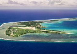
Dyess Army Airfield (ICAO: PKRO, FAA LID: ROI,[2] also known as Freeflight International Airport)[citation needed] is a military airfield on Roi-Namur, Kwajalein Atoll, Marshall Islands. It is owned by the United States Army.[1] Approximately 60 U.S. personnel reside on the base, with an additional 100 personnel commuting from Bucholz Army Airfield daily by plane.[3]
| Dyess Army Airfield | |||||||
|---|---|---|---|---|---|---|---|
| Part of Ronald Reagan Ballistic Missile Defense Test Site | |||||||
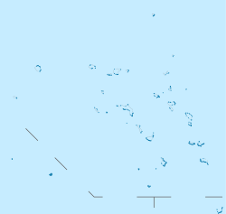
| Roi-Namur, Kwajalein Atoll in Marshall Islands | |||||||
 | |||||||
 The installation on a 1944 map | |||||||
 Dyess AAF  Dyess AAF | |||||||
| Coordinates | 09°23′49″N 167°28′15″E / 9.39694°N 167.47083°E | ||||||
| Site information | |||||||
| Owner | |||||||
| Airfield information | |||||||
| Identifiers | ICAO: PKRO, FAA LID: ROI | ||||||
| Elevation | 10 feet (3 m) AMSL | ||||||
| |||||||
| Source: Federal Aviation Administration[1] | |||||||
History edit
When the Japanese took control of the island during World War II they built an airfield that took the form of the number "4." After the 4th Marine Division landed the Seabees of 3rd Battalion, 20th Marines and the 109th Naval Construction Battalion made the field operational again. The Japanese designated the runways A, B, and C, with A being the vertical leg, B being the diagonal and C intersecting at a right angle to A. The Seabees of the Naval Base Kwajalein repaired runways A and C. Today the only runway that remains is A.
On September 19, 1950, the Marshall Islands' worst aviation accident happened near Dyess. A Douglas R5D-3 (56496) of the US Navy crashed into the Pacific shortly after takeoff from runway 07 on what was supposed to be a flight to Tokyo, killing all 26 onboard.[4]
Facilities edit
Dyess Army Airfield is at an elevation of 10 feet (3 m) above mean sea level. The runway is designated 04/22 with an asphalt surface measuring 4,499 by 150 feet (1,371 x 45.5 m).[1]
References edit
- ^ a b c FAA Airport Form 5010 for ROI PDF, retrieved 18 August 2022.
- ^ DoD Flight Information Publication (Enroute) - Supplement Pacific, Australasia and Antarctica. St. Louis, Missouri: National Geospatial-Intelligence Agency. 2005. p. B-77.
- ^ USAG-KA Public Affairs Office (2021). "Welcome to U.S. Army Garrison-Kwajalein Atoll". p. 54. Retrieved 18 August 2022.
- ^ "ASN Aircraft accident Douglas R5D-3 (DC-4) 56496 Kwajalein NAS (KWA)". aviation-safety.net. Retrieved 21 February 2023.
External links edit
- Accident history for PKRO at Aviation Safety Network