


Summary
Dzibanche (/tsʼiɓänˈtʃʰe/) (sometimes spelt Tz'ibanche)[1] is an archaeological site of the ancient Maya civilization located in southern Quintana Roo, in the Yucatan Peninsula of southeastern Mexico.[2] Dzibanche was a major Maya city and investigations in the first decade of the 21st century indicate that it was the early capital of the Kan dynasty, which later ruled from the great city of Calakmul. Dzibanche features the earliest known use of the Kaan dynasty emblem glyph.

Location and etymology edit
The name Dzibanche means "writing on wood" in the Mayan language; taking its name from the sculpted wooden lintels of the Temple of the Lintels.[3] Dzibanche is situated 130 kilometres (81 mi) northeast of the contemporary city of Calakmul.[4] The ruins lie in the south of Mexico's Quintana Roo state,[5] a short distance inland from the Bacalar Lagoon.[6] The ruins of the city are situated on a raised area surrounded by an extensive area of seasonal swampland, known as a bajo, featuring particularly fertile soils.[7]
History edit
During the Early Classic period of Mesoamerican chronology the city may have been the seat of the Kan ("snake") dynasty that later ruled from Calakmul to the southwest;[8] Dzibanche appears to have been the Kan capital in the 5th and 6th centuries.[9] The hieroglyphic stairway at Dzibanche contains the earliest known use of the Kan dynasty Emblem glyph, dated to AD 495.[10] Around 580 to 590, the Kan dynasty apparently moved their dynastic seat to Calakmul.[9] At the end of the Terminal Classic period, Dzibanche was one of the last cities in the Maya area to create a dated hieroglyphic text, in AD 909.[11]
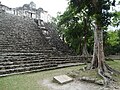
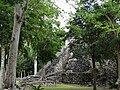
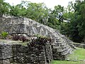
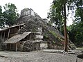
Site description edit

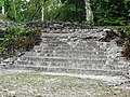
Dzibanche was a large city featuring architecture in the Peten style.[12] Excavations have uncovered a hieroglyphic stairway depicting sculpted representations of bound captives,[1] captured by Yuknoom Ch'een I, a Kan dynasty king of Dzibanche. One of these captives is named as Yax K'ahk' Jolo'm and, although his place of origin is not mentioned in the accompanying text, the form of his name indicates that he came from a city relatively close to Dzibanche itself.[13] At least two of sculpted blocks may date to the 5th century AD.[1]
The most important structures at Dzibanche include the Temple of the Captives, the Temple of the Lintels and the Temple of the Owl. The K'inichna' Pyramid is a large temple located outside of the site core. The Lamay Group is a small outlying architectural group that formed a part of the city.[3]
The Cormoranes Pyramid is the largest pyramid at Dizibanche. It was built during the 5th century AD using the Teotihuacan-influenced talud-tablero style of Maya architecture. The pyramid is decorated with friezes that were sculpted from stucco and coated with red paint; the friezes feature symbols that are also in the Teotihuacan style. The structure is the funerary pyramid of Sky Witness, one of the kings of the Kan dynasty.[6]
The K'inich Na' Pyramid ("House of the Sun God") is a large pyramid approximately 2 kilometres (1.2 mi) north of the site core. Two royal burials were discovered inside the structure, accompanied by jade offerings.[3] The K'inich Na' Pyramid is surrounded by a number of smaller palace-type structures and the group is linked to the site core by a causeway. The group was likely to be the home of an elite lineage group and was placed to extend the city's region of control over the northern parts of the surrounding bajo.[7]
Notes edit
- ^ a b c Martin and Grube 2000, p. 103.
- ^ Martini 2010, p. 377.
- ^ a b c Witschey and Brown 2011, p. 122.
- ^ Estrada-Belli 2011, p. 16. ITMB 2000.
- ^ Esparza Olguín and Pérez Gutiérrez 2009, p. 15.
- ^ a b Estrada-Belli 2011, p. 138.
- ^ a b Guderjan 2007, p. 123.
- ^ Sharer and Traxler 2006, p. 358. Estrada-Belli 2011, p. 16.
- ^ a b Canuto and Barrientos Q. 2011.
- ^ Braswell et al 2005, p. 170. Mesoweb 2008.
- ^ Valdés and Fahsen 2005, p. 160.
- ^ Martin and Grube 2000, p. 103. Witschey and Brown 2011, p. 122.
- ^ Velásquez García 2005, p. 3.
Gallery edit
References edit
- Braswell, Geoffrey E.; Gunn, Joel D.; Dominguez Carrasco, María del Rosario; Folan, William J.; Fletcher, Laraine A.; Morales López, Abel; Glascock, Michael D. (2005). "Defining the Terminal Classic at Calakmul, Campeche". In Arthur A. Demarest, Prudence M. Rice and Don S. Rice (ed.). The Terminal Classic in the Maya lowlands: Collapse, transition, and transformation. Boulder: University Press of Colorado. pp. 162–194. ISBN 0-87081-822-8. OCLC 61719499.
- Canuto, Marcello A.; Tomás Barrientos Q. (2011). "La Corona: un acercamiento a las políticas del reino Kaan desde un centro secundario del noroeste del Petén" [La Corona: an approach to politics in the kingdom of Kaan from a secondary center in Northwest Petén]. Estudios de Cultura Maya (in Spanish). 37. Mexico City, Mexico: Universidad Auntónoma de México (UNAM), Instituto de Investigaciones Filológicas. doi:10.19130/iifl.ecm.2011.37.12. ISSN 0185-2574.
- Esparza Olguín, Octavio Q.; Vania E. Pérez Gutiérrez (Winter 2009). "Archaeological and Epigraphic Studies in Pol Box, Quintana Roo" (PDF). The PARI Journal. IX (3). San Francisco, California, USA: Pre-Columbian Art Research Institute: 1–16. ISSN 1531-5398. Retrieved 2012-12-25.
- Estrada-Belli, Francisco (2011). The First Maya Civilization: Ritual and Power Before the Classic Period. Abingdon, Oxfordshire and New York: Routledge. ISBN 978-0-415-42994-8.
- Guderjan, Thomas H. (2007). The Nature of an Ancient Maya City: Resources, Interaction, and Power at Blue Creek, Belize. University of Alabama Press. ISBN 9780817354268.
- México South East (Map). 1:1,000,000. International Travel Maps. ITMB Publishing. 2000. ISBN 0-921463-227.
- Martini, I. Peter (2010). Landscapes and Societies: Selected Cases. Springer. ISBN 978-90-481-9413-1. Retrieved 20 December 2012.
- Martin, Simon; Nikolai Grube (2000). Chronicle of the Maya Kings and Queens: Deciphering the Dynasties of the Ancient Maya. London and New York: Thames & Hudson. ISBN 0-500-05103-8. OCLC 47358325.
- Mesoweb (2008). "Calakmul". Mesoweb. Retrieved 2012-12-25.
- Sharer, Robert J.; Loa P. Traxler (2006). The Ancient Maya (6th (fully revised) ed.). Stanford, CA: Stanford University Press. ISBN 0-8047-4817-9. OCLC 57577446.
- Valdés, Juan Antonio; Fahsen, Federico (2005). "Disaster in Sight: The Terminal Classic at Tikal and Uaxactun". In Arthur A. Demarest; Prudence M. Rice; Don S. Rice (eds.). The Terminal Classic in the Maya lowlands: Collapse, transition, and transformation. Boulder: University Press of Colorado. pp. 162–194. ISBN 0-87081-822-8. OCLC 61719499.
- Velásquez García, Erik (Fall 2005). "The Captives of Dzibanche" (PDF). The PARI Journal. 6 (2). San Francisco, California, USA: Pre-Columbian Art Research Institute: 1–4. ISSN 1531-5398. Retrieved 2012-12-24.
- Witschey, Walter R. T.; Clifford T. Brown (2011). Historical Dictionary of Ancient Mesoamerica. Plymouth, UK: Scarecrow Press. ISBN 9780810871670.
Further reading edit
- Martin, Simon (Fall 2005). "Of Snakes and Bats: Shifting Identities at Calakmul" (PDF). The PARI Journal. 6 (2). San Francisco, California, USA: Pre-Columbian Art Research Institute: 5–15. ISSN 1531-5398. Retrieved 2012-12-24.
18°38′19″N 88°45′33″W / 18.63861°N 88.75917°W