
KNOWPIA
WELCOME TO KNOWPIA

East Stour, Kent 
Summary
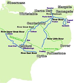
The River East Stour is one of the tributaries of the Great Stour in Kent.[1] The East Stour, 10.3 miles (16.5 km) long,[2]) rises on the Greensand ridge at Postling north of Hythe as a number of small streams. It then flows under the M20 motorway to continue in a westward direction: the river meanders across the Low Weald plain, passing Mersham on the way. The East Stour's confluence with the Great Stour is on both sides of Pledge's Mill at the foot of East Hill, Ashford.
| River East Stour | |
|---|---|
 River Stour and Tributaries | |
| Physical characteristics | |
| Source | |
| • location | Postling |
| Mouth | |
• location | Great Stour TR 01539 42793 Ashford |
• coordinates | 51°08′56″N 0°52′49″E / 51.14890°N 0.88020°E |
| Length | 10.3 mi (16.6 km) |
The South Willesborough Dykes are on the banks of the East Stour in Willesborough, Ashford and helps form part of the Ashford Green Corridor.
References edit
- ^ Clarke, R.G. (1967). Expansion at Ashford: An Appraisal of Its Impact on East Kent. Kent County Council. p. 1. Retrieved 9 July 2018.
- ^ The Environment Agency Archived March 16, 2007, at the Wayback Machine)