


Summary
East Taieri is a small township, located between Mosgiel and Allanton in New Zealand's Otago region. It lies on State Highway 1 en route between the city of Dunedin and its airport at Momona. It lies close to the southeastern edge of the Taieri Plain, hence its name.[4]
East Taieri | |
|---|---|
Settlement | |
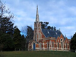 East Taieri Presbyterian Church | |
 | |
| Coordinates: 45°53′55″S 170°20′0″E / 45.89861°S 170.33333°E | |
| Country | New Zealand |
| Island | South Island |
| Region | Otago |
| District | Dunedin |
| Community board | Mosgiel-Taieri Community Board[1] |
| Electorates |
|
| Government | |
| • Territorial authority | Dunedin City Council |
| • Regional council | Otago Regional Council |
| • Mayor of Dunedin | Jules Radich |
| • Taieri MP | Ingrid Leary |
| • Te Tai Tonga MP | Tākuta Ferris |
| Area | |
| • Total | 3.13 km2 (1.21 sq mi) |
| Population (June 2023)[3] | |
| • Total | 2,460 |
| • Density | 790/km2 (2,000/sq mi) |
| Time zone | UTC+12 (NZST) |
| • Summer (DST) | UTC+13 (NZDT) |
| Area code | 03 |
| Local iwi | Ngāi Tahu |
Demographics edit
East Taieri covers 3.13 km2 (1.21 sq mi)[2] and had an estimated population of 2,460 as of June 2023,[3] with a population density of 786 people per km2.
| Year | Pop. | ±% p.a. |
|---|---|---|
| 2006 | 1,653 | — |
| 2013 | 1,935 | +2.28% |
| 2018 | 2,181 | +2.42% |
| Source: [5] | ||
East Taieri had a population of 2,181 at the 2018 New Zealand census, an increase of 246 people (12.7%) since the 2013 census, and an increase of 528 people (31.9%) since the 2006 census. There were 786 households, comprising 1,107 males and 1,074 females, giving a sex ratio of 1.03 males per female. The median age was 44.8 years (compared with 37.4 years nationally), with 426 people (19.5%) aged under 15 years, 312 (14.3%) aged 15 to 29, 1,089 (49.9%) aged 30 to 64, and 354 (16.2%) aged 65 or older.
Ethnicities were 94.4% European/Pākehā, 6.6% Māori, 1.2% Pasifika, 3.0% Asian, and 1.5% other ethnicities. People may identify with more than one ethnicity.
The percentage of people born overseas was 12.0, compared with 27.1% nationally.
Although some people chose not to answer the census's question about religious affiliation, 53.0% had no religion, 39.6% were Christian, 0.7% were Hindu, 0.4% were Muslim, 0.3% were Buddhist and 1.1% had other religions.
Of those at least 15 years old, 384 (21.9%) people had a bachelor's or higher degree, and 303 (17.3%) people had no formal qualifications. The median income was $43,200, compared with $31,800 nationally. 456 people (26.0%) earned over $70,000 compared to 17.2% nationally. The employment status of those at least 15 was that 993 (56.6%) people were employed full-time, 267 (15.2%) were part-time, and 48 (2.7%) were unemployed.[5]
Notable buildings edit
The East Taieri Presbyterian Church was designed by Robert Lawson and opened in 1870, replacing an earlier building which had served as both church and school. The church was extended with an administration and fellowship centre in the 1990s.[6]
The Presbyterian Manse was designed by N.Y.A. Wales and built in 1877–78. It was renovated in the late 1970s and again in 2001, and has been the home of the ministers of East Taieri Presbyterian Church.[7]
Education edit
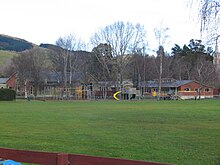
East Taieri School is a state contributing primary school catering for years 1 to 6.[8] It had a roll of 298 as of February 2024.[9] The school was founded as a preaching station in 1853 and moved to its current location in 1863.[10]
References edit
- ^ "2016 Mosgiel-Taieri Community Board Boundary" (PDF). dunedin.govt.nz. Dunedin City Council. Retrieved 2 June 2022.
- ^ a b "ArcGIS Web Application". statsnz.maps.arcgis.com. Retrieved 8 January 2024.
- ^ a b "Population estimate tables - NZ.Stat". Statistics New Zealand. Retrieved 25 October 2023.
- ^ Harriss, Gavin (November 2021). East Taieri, Otago (Map). NZ Topo Map.
- ^ a b "Statistical area 1 dataset for 2018 Census". Statistics New Zealand. March 2020. East Taieri (350300). 2018 Census place summary: East Taieri
- ^ "East Taieri Presbyterian Church". New Zealand Heritage List/Rārangi Kōrero. Heritage New Zealand. Retrieved 31 December 2021.
- ^ "Presbyterian Manse". New Zealand Heritage List/Rārangi Kōrero. Heritage New Zealand. Retrieved 31 December 2021.
- ^ Education Counts: East Taieri School
- ^ "New Zealand Schools Directory". New Zealand Ministry of Education. Retrieved 14 March 2024.
- ^ "About Us and History". East Taieri School. Retrieved 30 December 2021.