


Summary
Eastry is a civil parish in Kent, England, around 2+1⁄2 miles (4 km) southwest of Sandwich. It was voted "Kent Village of the Year 2005".
| Eastry | |
|---|---|
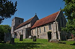 Church of St Mary the Virgin, Eastry | |
 Eastry Location within Kent | |
| Population | 2,492 (Including Ham. 2011)[1] |
| OS grid reference | TR332458 |
| District | |
| Shire county | |
| Region | |
| Country | England |
| Sovereign state | United Kingdom |
| Post town | SANDWICH |
| Postcode district | CT13 |
| Dialling code | 01304 |
| Police | Kent |
| Fire | Kent |
| Ambulance | South East Coast |
| UK Parliament | |
The name is derived from the Old English Ēast-rige, meaning "eastern province" (c.f. Sūþ-rige "southern province"), also recorded as Ēastregē, from ēasterra gē (lit. "more easterly area").[2]
Historical legends edit
Eastry lies on the Roman road north from Dover to Richborough Castle.
In the Early Middle Ages, Eastry was part of the Kingdom of Kent and was an important administrative centre.[3] It was here that a royal palace of the Saxon kings of Kent stood. One of Kent's oldest legends concerns King Ecgberht of Kent and the murder of his young cousins, Æthelred and Æthelberht, within the palace walls. According to the legend, the royal residence was passed to the priory of Christchurch in Canterbury as penance for the crime. The site of this ancient palace is believed to now be occupied by Eastry Court, adjacent to the church. An archaeological dig by Time Team in 2006 failed to find the royal palace.[4]
Parish church edit
Eastry's Grade I listed[5] Anglican church is dedicated to St Mary the Virgin. Within the church is a brass standard bushel measure given in 1792.
Governance edit
An electoral ward in the same name exists. This ward stretches south to Sutton, Kent with a total population taken at the 2011 census of 5,199.[6]
East Kent Light Railway edit
The East Kent Light Railway was opened to freight traffic in 1911 and passenger traffic in 1916. Its purpose was to serve the new coal mines which were being opened up in the area. Among the stations opened were 'Eastry' and 'Eastry South'. It was one of Colonel Stephens' lines, but was nationalized in 1948 becoming part of British Railways, Southern Region. Both the colliery and the line failed and the section north of Eythorne completely closed by 1951.
The village is also on the Miner's Way Trail. The trail links up the coalfield parishes of East Kent.[7]
Mills edit

Eastry has had a number of windmills over the centuries. There were four mills marked on the 1819 - 1843 Ordnance Survey map, one of which, the Upper Mill, has been converted into a house. Currently there are three windmills in Eastry.
Notable people edit
- Cyril Randolph (1826–1912), cricketer and clergyman
- Sir James Broadwood Lyall (Resting Place )GCIE KCSI (1838 – 4 December 1916) was a British administrator in the Indian Civil Service during the British Raj. Lyallpur, which was named after him, is the third-most-populous city in Pakistan, and the second-largest in the eastern province of Punjab.
- Sydney Greenstreet (1879-1954) stage and film actor
- Wing Commander Robert Stanford Tuck lived in the village in the village from 1953 until his retirement in the 1970s.
- Captain John Harvey 1740-1794
References edit
- ^ "Civil parish population 2011". Archived from the original on 7 October 2015. Retrieved 3 October 2015.
- ^ Hasted, Edward (1800). "Parishes". The History and Topographical Survey of the County of Kent. Vol. 10. Institute of Historical Research. pp. 98–121. Retrieved 3 December 2013.
- ^ Hawkes, Sonia Chadwick (1979). "Eastry in Anglo-Saxon Kent: its Importance and a Newly-Found Grave". Anglo-Saxon Studies in Archaeology and History. 1: 95.
- ^ Time Team s13 ep6
- ^ British Listed Buildings retrieved 20 July 2013
- ^ "Ward population 2011". Retrieved 3 October 2015.
- ^ "The History of the Coalfield Parishes". www.dover.gov.uk. Archived from the original on 13 January 2014. Retrieved 20 November 2013.
External links edit
- Notes on the village
- Eastry Cricket Club
- Eastry Parish Council Website - Village news, weather and Information
- Eastry Church Website - Church news and info