


Summary
Eaux-Bonnes (French: [o bɔn], "good waters"; Occitan: Aigas Bonas) is a commune in the Pyrénées-Atlantiques department in south-western France.
Eaux-Bonnes | |
|---|---|
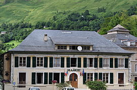 Town Hall | |
 Coat of arms | |
Location of Eaux-Bonnes .mw-parser-output .locmap .od{position:absolute}.mw-parser-output .locmap .id{position:absolute;line-height:0}.mw-parser-output .locmap .l0{font-size:0;position:absolute}.mw-parser-output .locmap .pv{line-height:110%;position:absolute;text-align:center}.mw-parser-output .locmap .pl{line-height:110%;position:absolute;top:-0.75em;text-align:right}.mw-parser-output .locmap .pr{line-height:110%;position:absolute;top:-0.75em;text-align:left}.mw-parser-output .locmap .pv>div{display:inline;padding:1px}.mw-parser-output .locmap .pl>div{display:inline;padding:1px;float:right}.mw-parser-output .locmap .pr>div{display:inline;padding:1px;float:left}html.skin-theme-clientpref-night .mw-parser-output .od,html.skin-theme-clientpref-night .mw-parser-output .od .pv>div,html.skin-theme-clientpref-night .mw-parser-output .od .pl>div,html.skin-theme-clientpref-night .mw-parser-output .od .pr>div{background:#000;color:#fff}html.skin-theme-clientpref-night .mw-parser-output .locmap{filter:grayscale(0.6)}@media(prefers-color-scheme:dark){html.skin-theme-clientpref-os .mw-parser-output .locmap{filter:grayscale(0.6)}html.skin-theme-clientpref-os .mw-parser-output .od,html.skin-theme-clientpref-os .mw-parser-output .od .pv>div,html.skin-theme-clientpref-os .mw-parser-output .od .pl>div,html.skin-theme-clientpref-os .mw-parser-output .od .pr>div{background:#000;color:#fff}}  Eaux-Bonnes  Eaux-Bonnes | |
| Coordinates: 42°58′26″N 0°23′27″W / 42.9739°N 0.3908°W | |
| Country | France |
| Region | Nouvelle-Aquitaine |
| Department | Pyrénées-Atlantiques |
| Arrondissement | Oloron-Sainte-Marie |
| Canton | Oloron-Sainte-Marie-2 |
| Intercommunality | Vallée d'Ossau |
| Government | |
| • Mayor (2020–2026) | Jean-Luc Braud[1] |
| Area 1 | 38.52 km2 (14.87 sq mi) |
| Population (2021)[2] | 190 |
| • Density | 4.9/km2 (13/sq mi) |
| Demonym(s) | Eaux-Bonnais, Eaux-Bonnaises |
| Time zone | UTC+01:00 (CET) |
| • Summer (DST) | UTC+02:00 (CEST) |
| INSEE/Postal code | 64204 /64440 |
| Elevation | 520–2,619 m (1,706–8,593 ft) (avg. 750 m or 2,460 ft) |
| 1 French Land Register data, which excludes lakes, ponds, glaciers > 1 km2 (0.386 sq mi or 247 acres) and river estuaries. | |
Description edit
Eaux-Bonnes is close to the small town of Laruns. It is situated at a height of 2,460 feet (750 m) at the entrance of a fine gorge, overlooking the confluence of two rivers. The village's waters were first documented in the middle of the 14th century. The Eaux-Chaudes spa is 5 miles (8.0 km) south-west of Eaux-Bonnes, and there is fine mountain scenery in the neighbourhood of both places, the Pic de Ger near Eaux-Bonnes.[3]
The climate which characterizes the town is of "mountain climate", according to the typology of climates of France which then has eight major types of climates in metropolitan France.[4]
Gourette is a winter sports resort located in the commune on the high mountain pass Col d'Aubisque.
History edit


The historian Auguste Lorieux (1796–1842) died in Eaux-Bonnes.
Nearby to the north-west on the Surcou road, is the impressive villa Cockade, the construction of which is detailed in Dornford Yates's novel The House That Berry Built.
Population edit
|
| ||||||||||||||||||||||||||||||||||||||||||||||||||||||||||||||||||||||||||||||||||||||||||||||||||||||||||||||||||
| Source: EHESS (1793-1999)[5] and INSEE[6] | |||||||||||||||||||||||||||||||||||||||||||||||||||||||||||||||||||||||||||||||||||||||||||||||||||||||||||||||||||
See also edit
- Aas, a village in Eaux-Bonnes.
- Ossau Valley
- Communes of the Pyrénées-Atlantiques department
References edit
- ^ "Répertoire national des élus: les maires" (in French). data.gouv.fr, Plateforme ouverte des données publiques françaises. 13 September 2022.
- ^ "Populations légales 2021". The National Institute of Statistics and Economic Studies. 28 December 2023.
- ^ One or more of the preceding sentences incorporates text from a publication now in the public domain: Chisholm, Hugh, ed. (1911). "Eaux-Bonnes". Encyclopædia Britannica. Vol. 8 (11th ed.). Cambridge University Press. pp. 839–840.
- ^ Joly, Daniel; Brossard, Thierry; Cardot, Hervé; Cavailhes, Jean; Hilal, Mohamed; Wavresky, Pierre (18 June 2010). "Les types de climats en France, une construction spatiale". Cybergeo: European Journal of Geography. doi:10.4000/cybergeo.23155.
- ^ Des villages de Cassini aux communes d'aujourd'hui: Commune data sheet Eaux-Bonnes, EHESS (in French).
- ^ Population en historique depuis 1968, INSEE