


Summary
Edam (2016 population: 480) is a village in the Canadian province of Saskatchewan within the Rural Municipality of Turtle River No. 469 and Census Division No. 17. Edam is located off Highway 26, south of Turtleford and north of Vawn.
Edam | |
|---|---|
| Village of Edam | |
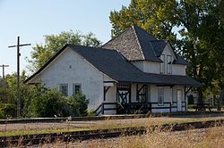 The historic Canadian Northern (later Canadian National) railway station in Edam | |
| Motto: Little piece of Holland in Saskatchewan | |
 Edam Location of Edam in Saskatchewan | |
| Coordinates: 53°11′N 108°46′W / 53.183°N 108.767°W | |
| Country | |
| Province | |
| Region | Central |
| Census division | 17 |
| Rural Municipality | Turtle River 469 |
| Post office Founded | 1908 |
| Village | 1911 |
| Government | |
| • Type | Municipal |
| • Governing body | Edam Village Council |
| • Mayor | Larry McDaid |
| • M.L.A. | Larry Doke |
| • MP | Rosemarie Falk |
| Area | |
| • Total | 1.19 km2 (0.46 sq mi) |
| Population (2016) | |
| • Total | 480 |
| • Density | 403.4/km2 (1,045/sq mi) |
| Time zone | UTC−6 (Central Standard Time) |
| • Summer (DST) | UTC−5 |
| Postal code | S0M 0V0 |
| Highways | |
| Railways | Canadian National Railway |
| Website | Village of Edam |
| [1][2][3][4] | |
The village is known as a "Little piece of Holland in Saskatchewan." Established in 1907, the hamlet was named for the city of Edam in the Netherlands, after the name Amsterdam was rejected by the Saskatchewan Government Office as "too long".[5]
History edit
Edam incorporated as a village on October 12, 1911.[6]
Demographics edit
In the 2021 Census of Population conducted by Statistics Canada, Edam had a population of 476 living in 199 of its 234 total private dwellings, a change of -1.9% from its 2016 population of 485. With a land area of 1.14 km2 (0.44 sq mi), it had a population density of 417.5/km2 (1,081.4/sq mi) in 2021.[9]
In the 2016 Census of Population, the Village of Edam recorded a population of 480 living in 179 of its 210 total private dwellings, a 7.5% change from its 2011 population of 444. With a land area of 1.19 km2 (0.46 sq mi), it had a population density of 403.4/km2 (1,044.7/sq mi) in 2016.[10]
Notable people edit
- Fiona Smith-Bell, hockey player who played on the Canadian women's hockey team.[11]
- Wayne Wouters, former Clerk of the Privy Council (the most senior civil servant) in the Government of Canada.
Transportation edit
See also edit
References edit
- ^ National Archives, Archivia Net, Post Offices and Postmasters, archived from the original on 2006-10-06, retrieved 2007-05-26
- ^ Government of Saskatchewan, MRD Home. "Municipal Directory System". Archived from the original on 2016-01-15. Retrieved 2013-06-21.
- ^ Canadian Textiles Institute. (2005), CTI Determine your provincial constituency, archived from the original on 2007-09-11, retrieved 2013-06-21
- ^ Commissioner of Canada Elections, Chief Electoral Officer of Canada (2005), Elections Canada On-line, archived from the original on 2007-04-21, retrieved 2013-06-21
- ^ The Village of Edam website
- ^ "Urban Municipality Incorporations". Saskatchewan Ministry of Government Relations. Archived from the original on October 15, 2014. Retrieved June 1, 2020.
- ^ "Saskatchewan Census Population" (PDF). Saskatchewan Bureau of Statistics. Archived from the original (PDF) on September 24, 2015. Retrieved May 31, 2020.
- ^ "Saskatchewan Census Population". Saskatchewan Bureau of Statistics. Retrieved May 31, 2020.
- ^ "Population and dwelling counts: Canada, provinces and territories, census divisions and census subdivisions (municipalities), Saskatchewan". Statistics Canada. February 9, 2022. Retrieved April 1, 2022.
- ^ "Population and dwelling counts, for Canada, provinces and territories, and census subdivisions (municipalities), 2016 and 2011 censuses – 100% data (Saskatchewan)". Statistics Canada. February 8, 2017. Retrieved May 30, 2020.
- ^ "Fiona Smith-Bell". Saskatchewan Sports Hall of Fame. Retrieved July 7, 2019.
External links edit
- Official website
53°11′N 108°46′W / 53.183°N 108.767°W