


Summary
El Tiro Gliderport (FAA LID: AZ67), formally Marana Auxiliary Army Airfield No. 5 (Sahuaro Field), is marked on the Phoenix sectional chart is a non-towered private use gliderport 23 mi (20 nmi; 37 km) northwest of Tucson, Arizona, United States.[1] The airport property is leased from the Bureau of Land Management and has been operated by the Tucson Soaring Club, Inc. (a chapter of the Soaring Society of America) since 1983.[2][3][4]
El Tiro Gliderport | |||||||||||||||||||||||||||
|---|---|---|---|---|---|---|---|---|---|---|---|---|---|---|---|---|---|---|---|---|---|---|---|---|---|---|---|
 | |||||||||||||||||||||||||||
| Summary | |||||||||||||||||||||||||||
| Airport type | Private use; permission required prior to landing | ||||||||||||||||||||||||||
| Operator | Tucson Soaring Club, Inc. | ||||||||||||||||||||||||||
| Location | Pima County, Arizona | ||||||||||||||||||||||||||
| Elevation AMSL | 2,100 ft / 640 m | ||||||||||||||||||||||||||
| Coordinates | 32°25′37.25″N 111°23′22.39″W / 32.4270139°N 111.3895528°W | ||||||||||||||||||||||||||
| Website | http://tucsonsoaring.org/ | ||||||||||||||||||||||||||
| Map | |||||||||||||||||||||||||||
 AZ67 Location of airport in Arizona  AZ67 AZ67 (the United States) | |||||||||||||||||||||||||||
| Runways | |||||||||||||||||||||||||||
| |||||||||||||||||||||||||||
Marana Auxiliary Army Airfield No. 5 (aka Sahuaro Field) was one of five auxiliary fields that served Marana Army Air Field (now Pinal Airpark) and is one of many Arizona World War II Army Airfields. Sahuaro Field first appeared on the Phoenix sectional chart in 1945. The airfield was originally described as a "206 acres (83 ha) square-shaped property having a 3,000 ft (910 m) square asphalt landing mat." After World War II there is evidence of the airfield being used by the United States Air Force in 1957 for pilot training in North American T-6 Texan and T-28 Trojan aircraft. From 1958 the airport was reportedly abandoned until Tucson Soaring Club leased the property.[5][6]
Facilities edit
- 8L/26R measuring 5,000 ft × 100 ft (1,524 m × 30 m), dirt
- 8L/26R measuring 1,300 ft × 22 ft (396.2 m × 6.7 m), asphalt, superimposed on 8L/26R
- 8/26 measuring 5,120 ft × 100 ft (1,561 m × 30 m), dirt center
- 8R/26L measuring 5,000 ft × 100 ft (1,524 m × 30 m), dirt
- 17L/35R measuring 5,000 ft × 100 ft (1,524 m × 30 m), dirt/treated
- 17R/35L measuring 5,000 ft × 100 ft (1,524 m × 30 m), dirt/treated
Old runways edit
- 4L/23R 3,300 ft × 280 ft (1,006 m × 85 m), asphalt
- 4R/23L 3,300 ft × 280 ft (1,006 m × 85 m), asphalt
- 13L/32R 3,300 ft × 280 ft (1,006 m × 85 m), asphalt
- 13R/32R 3,300 ft × 280 ft (1,006 m × 85 m), asphalt
Gallery edit
-
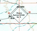
 1945 Phoenix sectional chart shows El Tiro Gliderport as Marana Auxiliary Army Airfield No. 5 (aka Sahuaro Field).
 -
 1957 USGS topo map of Marana Auxiliary Airfield No 5
 -
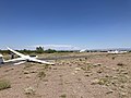 Grob G103 Twin Astir glider preparing to launch in tow by the Piper PA-25 Pawnee tow plane at El Tiro in 2020


See also edit
References edit
- ^ "AirNav: AZ67 - El Tiro Gliderport". www.airnav.com. Retrieved 2018-04-03.
- ^ "Tucson Soaring Club Introduction for New Members June 2008". TUCSON SOARING CLUB.
- ^ "Gliding is peaceful pastime for Tucsonan, AZ Jewish Post". Arizona Jewish Post. Retrieved 2018-04-03.
- ^ "Tucson Soaring Club". tucsonsoaring.org. Retrieved 2018-04-03.
- ^ "Abandoned & Little-Known Airfields: Arizona, Northern Tucson area". www.airfields-freeman.com. Retrieved 2018-03-18.
- ^ "Airport history". Town of Marana. Retrieved 2018-03-18.
External links edit
- Resources for this airport:
- FAA airport information for AZ67
- AirNav airport information for AZ67
- FlightAware airport information and live flight tracker
- SkyVector aeronautical chart for AZ67