


Summary
Ella Bay is a national park beside Ella Bay and spans the localities of Wanjuru in the Cassowary Coast Region and Eubenangee in the Cairns Region, Queensland, Australia.[1]
| Ella Bay National Park Queensland | |
|---|---|
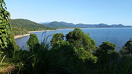 Ella Bay from Heath's point, 2017 | |
 Ella Bay National Park | |
| Coordinates | 17°23′44″S 146°03′24″E / 17.39556°S 146.05667°E |
| Established | 1952 |
| Area | 37.10 km2 (14.32 sq mi) |
| Managing authorities | Queensland Parks and Wildlife Service |
| See also | Protected areas of Queensland |
Geography edit
The park is 1329 km northwest of Brisbane. It is part of the Coastal Wet Tropics Important Bird Area, identified as such by BirdLife International because of its importance for the conservation of lowland tropical rainforest birds.[2] It can be reached via Flying Fish Point on Ella Bay Road.[3] The largest and most prominent mountain in the park is Mount Arthur, which rises to 478 metres above sea level.[4]
Wildlife edit
394 species of animals and 462 species of plants have been recorded in Ella Bay National Park. Of these, 12 species of animals and 13 species of plants are rare or endangered.[5]
Amenities edit
Adjacent to the park are camping facilities which are closed as of 2017[update].[citation needed]
See also edit
References edit
- ^ "Ella Bay National Park – national park in Cassowary Coast Region (entry 11516)". Queensland Place Names. Queensland Government. Retrieved 12 December 2017.
- ^ BirdLife International. (2011). Important Bird Areas factsheet: Coastal Wet Tropics. Downloaded from "BirdLife International - conserving the world's birds". Archived from the original on 30 June 2007. Retrieved 2013-01-11. on 2011-12-16.
- ^ "Queensland Globe". State of Queensland. Retrieved 12 December 2017.
- ^ "Ella Bay National Park". PeakVisor. Retrieved 27 March 2022.
- ^ "Ella Bay National Park — facts and maps". wetlandinfo.des.qld.gov.au. Retrieved 28 March 2022.