


Summary
Ellingwood Point is a high mountain summit in the Sangre de Cristo Range of the Rocky Mountains of North America. The 14,048-foot (4,282 m) fourteener is located on the Sierra Blanca Massif, 9.9 miles (16.0 km) north by east (bearing 7°) of the Town of Blanca, Colorado, United States, on the drainage divide separating the Rio Grande National Forest and Alamosa County from the San Isabel National Forest and Huerfano County.[1][2][3] Ellingwood Point was named in honor of Albert Russell Ellingwood, an early pioneer of mountain climbing in the Western United States and in Colorado in particular.
| Ellingwood Point | |
|---|---|
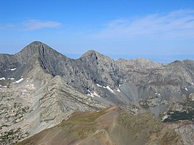 View of Blanca Peak (left) and Ellingwood Point (center) from summit of Mount Lindsey | |
| Highest point | |
| Elevation | 14,048 ft (4,282 m)[1][2] |
| Prominence | 342 ft (104 m)[2] |
| Parent peak | Blanca Peak[2] |
| Isolation | 0.52 mi (0.84 km)[2] |
| Listing | Colorado Fourteener 42nd |
| Coordinates | 37°34′57″N 105°29′33″W / 37.5825045°N 105.4925114°W[3] |
| Geography | |
 Ellingwood Point | |
| Location | Alamosa and Huerfano counties, Colorado, United States[3] |
| Parent range | Sangre de Cristo Range, Sierra Blanca Massif[2] |
| Topo map | USGS 7.5' topographic map Blanca Peak, Colorado[3] |
| Climbing | |
| Easiest route | South Face: Difficult Hike, class 2[4] |
Mountain edit
Ellingwood Point only barely qualifies as an independent peak under the 300-foot (91 m) topographic prominence cutoff which is standard in Colorado. It is also quite close to its parent peak, Blanca Peak. Hence its inclusion in fourteener lists has been somewhat controversial. However most authorities do consider it a true fourteener.[5]
Names edit
- Ellingwood Peak
- Ellingwood Point – 1972 [3]

Climate edit
According to the Köppen climate classification system, the mountain is located in an alpine subarctic climate zone with cold, snowy winters, and cool to warm summers.[6] Due to its altitude, it receives precipitation all year, as snow in winter, and as thunderstorms in summer, with a dry period in late spring.
See also edit
- List of mountain peaks of Colorado
 Mountains portal
 Colorado portal
References edit
- ^ a b The elevation of Ellingwood Point includes an adjustment of +1.789 m (+5.87 ft) from NGVD 29 to NAVD 88.
- ^ a b c d e f "Ellingwood Point, Colorado". Peakbagger.com. Retrieved October 20, 2014.
- ^ a b c d e "Ellingwood Point". Geographic Names Information System. United States Geological Survey, United States Department of the Interior. Retrieved October 20, 2014.
- ^ "Ellingwood Point Routes". 14ers.com.
- ^ Louis W. Dawson II (1996). Dawson's Guide to Colorado's Fourteeners, Volume 2. Blue Clover Press. ISBN 0-9628867-2-6.
- ^ Peel, M. C.; Finlayson, B. L.; McMahon, T. A. (2007). "Updated world map of the Köppen−Geiger climate classification". Hydrol. Earth Syst. Sci. 11. ISSN 1027-5606.
External links edit
 Definitions from Wiktionary
 Media from Commons
 News from Wikinews
 Quotations from Wikiquote
 Texts from Wikisource
 Textbooks from Wikibooks
 Resources from Wikiversity
- "Ellingwood Point". 14ers.com.
- "Ellingwood Point". SummitPost.org. Retrieved 2011-05-15.