


Summary
The Elz is a river in Baden-Württemberg, Germany, a right tributary of the Rhine. It rises in the Black Forest, near the source of the Breg. The Elz flows through Elzach, Waldkirch and Emmendingen before reaching the Rhine near Lahr. Its length is approx. 121 km (75 mi).
| Elz | |
|---|---|
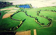
 View of the Hörnleberg, Obereck and Kandel (right) looking southeast over the middle Elz valley and Waldkirch | |
 Course of the Elz | |
| Location | |
| Country | Germany |
| State | Baden-Württemberg |
| Reference no. | DE: 2338 |
| Physical characteristics | |
| Source | |
| • elevation | 1,038 m above sea level (NHN) |
| Mouth | |
• elevation | 137 m above sea level (NHN) |
| Length | 121.0 km (75.2 mi) [1] (over the Old Elz) |
| Basin size | 1,555 km2 (600 sq mi) [1] |
| Basin features | |
| Progression | Rhine→ North Sea |
| Landmarks |
|
| Tributaries | |
| • left | Wilde Gutach, Glotter/Lossele, Dreisam, Eichstetter Mühlbach |
| • right | Biederbach, Brettenbach, Bleiche, Ettenbach |
The lower reaches of the Elz are by-passed by the Leopold Canal, a flood relief canal.
Course edit

The Elz rises north of Furtwangen in the area of the Brend and the Rohrhardsberg mountains (between the Furtwänglehof and the Kolmenhof) not far from the source of the Breg which is hydrographically the source of the Danube.
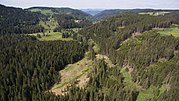
In its upper reaches the Elz flows in a northerly direction, initially through a high valley with pasture land, bog and ice age glacial landforms. Then after a steep drop at the little Elz Falls, it continues through a deeply incised, wooded and sparsely populated V-shaped valley.

In the Oberprechtal valley it bends sharply towards the southwest. This is the start of the middle (actual) Elz valley, which runs in a straight line towards the southwest, separating the High Black Forest (700 to 900 m) to the southeast from the far lower parts of the Central Black Forest. In the now densely populated valley are the town of Elzach, the villages of Winden and Gutach im Breisgau, where the Elz receives the waters of the Wild Gutach, which is just under half its size. Below the town of Waldkirch the Elz enters the Upper Rhine Plain near Denzlingen in the Freiburg Bay. From now on it flows in a northwesterly direction, past Emmendingen and Teningen. Some of the water of the Elz is diverted into a millstream through Emmendingen, where it drives several hydropower stations and enhances the appearance of the town. Near Riegel on the Kaiserstuhl the Elz merges with the Dreisam from Freiburg im Breisgau and the Old Dreisam.
Soon thereafter the Elz forks again: a certain amount of water (up to 8.5 m3/s) flows down the Old Elz (Alte Elz) through the Europapark Rust to its mouth on the Rhine. Other quantities of water, on average about 13.2 m3/s, is fed along the Leopold Canal, built by Johann Gottfried Tulla, northwest of Rheinhausen into the Rhine. The Old Elz empties higher up, near Schwanau, into the Rhine. Today it is led down various Old Rhine channels parallel to the Rhine to the southern edge of Kehl, a distance of 121 kilometres from the source; formerly it was over 90 kilometres long.
Tributaries edit
The table shows all tributaries that are longer than 5 kilometres, with the exception of millstreams alongside rivers.[2] Based on the waterbody number (Fließgewässerkennziffer), the Frischnaubach is the highest tributary - it discharges into the Elz in the parish of Prechtal. The Ettenbach is the lowest tributary and empties into the Elz just before Grafenhausen. All tributaries have their catchment areas in the county of Emmendingen, with the exception of the Ettenbach, which flows through in Ortenaukreis.
| Distance from mouth (km) | GKZ[Z 1] | Name | Side | Discharges into[Z 2] | Length (km)[Z 3] | Catchment (km2)[Z 4] | Mouth location | Mouth elevation[Z 5] (m above NN) | Remarks |
|---|---|---|---|---|---|---|---|---|---|
| 98.912 | 2338-12 | Frischnaubach | right | Elz | 5.7 | 11.6 | Elzach-Eilet | 477.8 | |
| 95.745 | 2338-194 | Yachbach | left | Elz | 7.8 | 19.5 | Elzach, sewage works | 343 | |
| 95.434 | 2338-2 | Biederbach | right | Elz | 10.3 | 31.8 | Elzach, Ortsende | 340 | |
| 91.997 | 2338-32 | Spitzenbach | right | Elz | 6.4 | 11.0 | Winden im Elztal-Niederwinden | 317 | |
| 87.349 | 2338-392 | Siegelbach | right | Elz | 6.4 | 13.4 | Gutach im Breisgau-Stollen | 289.0 | |
| 86.934 | 2338-4 | Wilde Gutach | left | Elz | 25.2 | 129.9 | Gutach im Breisgau | 287 | |
| 85.966 | 2338-512 | Talbach | left | Elz | 6.2 | 9.1 | Gutach im Breisgau | 281 | [3] |
| 83.477 | 2338-53126 | Altersbach | left | Elz | 6.6 | 6.7 | Waldkirch | 266 | [3][4] |
| 80.463 | 2338-532 | Dettenbach | left | Elz | 6.2 | 9.8 | Waldkirch, Ortsende | 247 | |
| 77.985 | 2338-54 | Lossele | left | Elz | 20.1 | 49.8 | Denzlingen | 236.8 | right and main lower reaches of the Glotter |
| 70.420 | 2338-6 | Brettenbach | right | Elz | 24.2 | 71.2 | Emmendingen | 192 | |
| 63.341 | 2338-8 | Dreisam | left | Elz | 48.8 | 339.7 | Riegel am Kaiserstuhl | 178 | Catchment area excludes the Old Dreisam |
| 18 | 2338-894 | Old Dreisam (Alte Dreisam) | left | Dreisam | 38.2 | 258.8 | Riegel am Kaiserstuhl | 178 | is the left Dreisam tributary at its mouth |
| 62.817 | 2338-9112 | Wihlbach | left | Elz | 5.0 | 4.9 | Riegel am Kaiserstuhl | 177 | |
| 60.077 | 2338-912 | Malterdinger Dorfbach | right | Old Elz (Alte Elz) | 6.6 | 15.8 | Kenzingen-Hecklingen | 177 | |
| 57.108 | 2338-914 | Little Elz (Kleine Elz) | right | Old Elz | 6.6 | 8.5 | Kenzingen | 176 | |
| 50.119 | 2338-92 | Bleichbach | right | Old Elz | 18.4 | 60.8 | Herbolzheim, Mühlehof | 170 | |
| 47.273 | 2338-932 | Grundelbach | right | Old Elz | 5.6 | 6.8 | Rust | 165 | |
| 42.231 | 2338-94 | Ettenbach | right | Old Elz | 18.4 | 59.9 | Kappel-Grafenhausen-Kappel am Rhein | 161 | |
| 38.466 | 2338-954 | Taubergießen | left | Old Elz | 8.9 | 8.7 | Kappel, sewage works | 157 | [3] begins as left tailstream of the Old Elz near Rust |
| 38.038 | 2338-96 | Kapuzinerbach | right | Old Elz | 14.3 | 24.4 | Kappel, sewage works | 157 | |
| 36.831 | 2338-98 | (Old Rhine channel) | left | Old Elz | 43.2 | 134.2 | Schwanau-Wittenweier | 156 | right old channel of the Rhine |
| 24.316 | 2338-992 | Ottenheimer Mühlbach | right | Raukehle/Mühlbach | 9.7 | 13.8 | Schwanau-Ottenheim | 150 | begins as the right tailstream at Schwanau-Wittenweier |
- ^ Official German waterbody number. A dash has been added after "2338" (the ID for the Elz itself) for readability.
- ^ The name of the Elz at the tributary mouth.
- ^ Length based on the Gewässernetz layer (AWGN) of the online map server of the LUBW. The length may include upper reaches with a different name and the name of upper reaches may transition from hydrologically dominating tributaries to become the name run.
- ^ Catchment area from the Basiseinzugsgebiet (AWGN) layer of the online map server of the LUBW, in some cases calculated from the sub of subareas.
- ^ Height from the contour map on the map background layer Topographische Karte or text entries from Map services of the Baden-Württemberg State Office for the Environment, Survey and Conservation (Landesanstalt für Umwelt, Messungen und Naturschutz Baden-Württemberg). This entry has an error margin, which may be caused by interpolation errors or because the height difference between the river height and terrain height cannot be determined from the map.

Fauna edit
Commonly found species of fish in the Elz are the:[5]
Gallery edit
- Aerial photographs
-
 View upriver via Emmendingen to the Kandel
 -
 The "Old Elz" between Kenzingen and Rheinhausen (Breisgau)
 -
 Upper Elz, looking north


References edit
- ^ a b Map services of the Baden-Württemberg State Office for the Environment, Survey and Conservation (Landesanstalt für Umwelt, Messungen und Naturschutz Baden-Württemberg)
- ^ Length from the Gewässernetz (AWGN) layer from Map services of the Baden-Württemberg State Office for the Environment, Survey and Conservation (Landesanstalt für Umwelt, Messungen und Naturschutz Baden-Württemberg)
- ^ a b c Einzugsgebiet abgemessen auf dem Hintergrundlayer Topographische Karte des Online-Kartenservers der LUBW.
- ^ Der Altersbach mündet in einen nahen, etwa parallelen Gewerbekanal. Stationierung ungefähr auf die Elz übergepaust, entsprechend die Mündungshöhe.
- ^ Schaubild IG-Elz
External links edit
- Course of the Elz at: Map services of the Baden-Württemberg State Office for the Environment, Survey and Conservation (Landesanstalt für Umwelt, Messungen und Naturschutz Baden-Württemberg)
- Interessengemeinschaft-Elz e. V. – numerous photographs, including some historical photographs.
- EG Wasserrahmenrichtlinie Bericht zur Bestandsaufnahme Teilbearbeitungsgebiet 31 Elz-Dreisam[permanent dead link] (pdf file; 1.15 MB)
- ELZ: Fluss oder Kanal?