


Summary
Englorie Park is a suburb of Sydney, in the state of New South Wales, Australia. Englorie Park is located 55 kilometres south-west of the Sydney central business district, in the local government area of the City of Campbelltown and is part of the Macarthur region.
| Englorie Park Sydney, New South Wales | |||||||||||||||
|---|---|---|---|---|---|---|---|---|---|---|---|---|---|---|---|
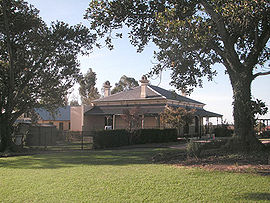 Englorie Park House | |||||||||||||||
| Population | 416 (2016 census)[1] | ||||||||||||||
| • Density | 3,703/km2 (9,590/sq mi) | ||||||||||||||
| Established | 2000 | ||||||||||||||
| Postcode(s) | 2560 | ||||||||||||||
| Elevation | 112 m (367 ft) | ||||||||||||||
| Area | 0.11235 km2 (0.0 sq mi) | ||||||||||||||
| Location | 55 km (34 mi) south-west of Sydney | ||||||||||||||
| LGA(s) | City of Campbelltown | ||||||||||||||
| State electorate(s) | Campbelltown | ||||||||||||||
| Federal division(s) | Macarthur | ||||||||||||||
| |||||||||||||||
Englorie Park is the smallest suburb in NSW,[2] situated between the suburbs of Ambarvale, Campbelltown and Glen Alpine.[3] The suburb is almost entirely residential, except for a childcare centre that operates within the historic Englorie Park House. The majority of housing within the suburb is detached, with a minority of townhouses. Englorie Park is situated very close to the Macarthur Square shopping centre and Campbelltown Hospital.
History edit
As well as being relatively small, Englorie Park is also a relatively new suburb, having only been designated by the Geographical Names Board in March 2000. Prior to then it was part of the suburb of Campbelltown.[4] It draws its name from the historic Englorie Park House which was built in 1880 by greyhound breeder Alfred Park. Originally called Parkholme, the property was renamed Euglorie Park by Charles Burcher of Euglo Station, Condobolin. This later became corrupted to Englorie Park.[5]
Population edit
In the 2016 Census, there were 416 people in Englorie Park. 55.8% of people were born in Australia and 57.8% of people spoke only English at home. The most common response for religion was Catholic at 29.9%.[1]
References edit
- ^ a b Australian Bureau of Statistics (27 June 2017). "Englorie Park (State Suburb)". 2016 Census QuickStats. Retrieved 20 January 2019.
 Material was copied from this source, which is available under a Creative Commons Attribution 4.0 International License.
- ^ "PSMA 2018".
- ^ UBD Sydney Street Directory, Universal Publishing, 2007
- ^ "Englorie Park". Geographical Names Register (GNR) of NSW. Geographical Names Board of New South Wales. Retrieved 5 August 2013.
- ^ "Attractions in Macarthur". Macarthur Tourism. Archived from the original on 23 October 2004. Retrieved 6 June 2009.
34°04′55″S 150°47′38″E / 34.082°S 150.794°E