


Summary
Erattupetta is a municipal town located in Kottayam district of Kerala state, India. It is located 38 km (24 mi) east of Kottayam, the district capital. It is also called as Aruvithura attributed to the church dating back many centuries
Erattupetta | |
|---|---|
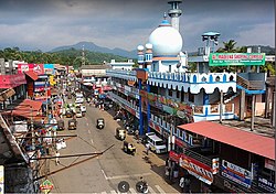 Central junction, Erattupetta | |
 Erattupetta Location in Kerala, India  Erattupetta Erattupetta (India) | |
| Coordinates: 9°42′N 76°47′E / 9.7°N 76.78°E | |
| Country | |
| State | Kerala |
| District | Kottayam |
| Government | |
| • Type | Municipality |
| • Municipal Chairperson | Suhara Abdul Khader |
| • Municipal Vice Chairman | Muhammad Ilyas (INC) |
| Area | |
| • Total | 18.29 km2 (7.06 sq mi) |
| Elevation | 24 m (79 ft) |
| Population (2011)[1] | |
| • Total | 34,814 |
| • Density | 1,900/km2 (4,900/sq mi) |
| Languages | |
| • Official | Malayalam, English |
| Time zone | UTC+5:30 (IST) |
| Vehicle registration | KL-35 |
| Literacy | 95% |
| Website | Official website |
Erattupetta panchayath was founded in 1964 and upgraded to a municipality in 2015.
The "Eraaru" part in all the variations of the names arose from the geographical location, where the two rivers (aaru) merge as single one and "Petta" means town. Erattupetta is situated in the foothills of High Ranges. Hence the place is also known as "the gateway of High range/Malanadu."
Etymology edit
The "Eraaru" part in all the variation of the names arose from the geographical location, where the two rivers (aaru) merge as a single one. Erattupetta is situated in the foothills of High Ranges. 'Peta' means town in Dravidian languages. Earlier it was known as 'Erapoli' or 'Erapuzha'. It was the commercial capital of the Poonjar principality until 1949.
Native Peoples edit
The indigenous population can be broadly divided into three groups. It includes the base class, the children of the soil - the Hindu sects and the Christian Muslim sects that have converted from them.
Tamil Immigrants - The most important of these were the (Rawther) Khan family Muslims who came from Madurai in Tamil Nadu in the twelfth century along with the Poonjar royal family along with their loyal servants and bodyguards. The Hindus belonging to the Chetti tribe and the Rawthers who left the country in the 14th century from Tamil areas. They still speak Malayalam mixed with Tamil. These include the Brahmin families of Tamil Nadu who came from Tamil Nadu and were converted to Christianity by St.Thomas and many Jewish families who came from Tamil Nadu and converted to Christianity.
Malayali Immigrants - Christians who migrated from Kodungallur with the advent of Christianity and Nilakkal in the fourteenth century, Muslims who came from Edappally near Kochi after the advent of Islam, Mehtar sect, and later Muslims from various families who came from Malappuram and Ernakulam districts belong to this category. Apart from this, there is another sect with roots in Saudi Arabia. They are the Labbas, descendants of the previously mentioned Shaikh Saeed Bawa. While the Muslims, who depended on trade in these groups, settled in Eratupetta itself, the Christians moved to the nearby hills in search of fertile farmlands. Others who were laborers moved to different areas depending on the availability of work. This is the reason why Eratupetta became a Muslim majority area.
Economy edit
In the past, hill produce from the Cardamom Hills were brought down by the Muthuvan for trade. Erattupetta is a trading centre for spices, rubber, areca nut and other agricultural products .Wagamon, a Hill Station, lies some 22 km east of Erattupetta. Erattupetta has a large number of expatriate population living in Gulf countries, especially in United Arab Emirates and Saudi Arabia.
Demographics edit
Erattupetta is a municipal Town city situated in Meenachil taluka of Kottayam district. As per the Population Census 2011, there are a total 7,686 families residing in the Erattupetta city. The total population of Erattupetta is 34,814 out of which 17,555 are males and 17,259 are females thus the Average Sex Ratio of Erattupetta is 983.
The population of Children aged 0-6 years in Erattupetta city is 4474 which is 13% of the total population. There are 2294 male children and 2180 female children between the age 0-6 years. Thus as per the Census 2011 the Child Sex Ratio of Erattupetta is 950 which is less than Average Sex Ratio (983).
As per the Census 2011, the literacy rate of Erattupetta is 95.5%. Thus Erattupetta has a lower literacy rate compared to 97.2% of Kottayam district. The male literacy rate is 97.39% and the female literacy rate is 93.51% in Erattupetta.
Geography edit

Erattupetta can be accessed easily from north Kerala via the Angamaly-Muvattupuzha-Thodupuzha-Muttom route. It is well connected to Tamil Nadu via Kottayam-Kumali (K K) Road to Madurai through the nearest town Mundakkayam via Parathanam, which is 27 kilometres from Erattupetta.
It has an average elevation of 36 metres (118 feet).
Politics edit
Erattupetta is a municipality. The current municipal chairperson is Suhara Abdul Khader.
Erattupetta comes under the Pathanamthitta Loksabha constituency and the Poonjar assembly constituency. Erattupetta is represented in the Loksabha by Anto Antony and in the state assembly by Adv .Sebastian Kulathunkal.
Localities edit
- Aruvithura , Thekekkra, Nadackal ,Aniyilappu, Kaduvamoozhi, Elppunkal, Mattakkad etc...
Notable people edit
References edit
- ^ "Kerala (India): Districts, Cities and Towns - Population Statistics, Charts and Map".
External links edit
- https://erattupettamunicipality.lsgkerala.gov.in/en/
- http://lsgkerala.in/erattupettapanchayat/
- https://www.citypopulation.de/en/india/kerala/