


Summary
The ethno-linguistic composition of Austria-Hungary according to the census of 31 December 1910 was as follows:[1]
Population edit


| Area | Number | % |
|---|---|---|
| Cisleithania[2] | 28,571,934 | 55.6 |
| Transleithania[3] | 20,886,487 | 40.6 |
| Bosnia and Herzegovina (Austro-Hungarian condominium) | 1,931,802 | 3.8 |
| Total | 51,390,223 | 100.0 |
Largest cities edit
| Rank | Current English name | Contemporary official name[6] | Other | Present-day country | Population in 1910 | Present-day population |
|---|---|---|---|---|---|---|
| 1. | Vienna | Wien | Bécs, Beč, Dunaj | Austria | 2,031,498
(city without the suburb 1,481,970) |
1,840,573
(Metro: 2,600,000) |
| 2. | Prague | Prag, Praha | Prága | Czech Republic | 668,000
(city without the suburb 223,741) |
1,301,132
(Metro: 2,620,000) |
| 3. | Trieste | Triest | Trieszt, Trst | Italy | 229,510 | 204,420 |
| 4. | Lviv | Lemberg, Lwów | Ilyvó, Львів, Lvov, Львов | Ukraine | 206,113 | 728,545 |
| 5. | Kraków | Krakau, Kraków | Krakkó, Krakov | Poland | 151,886 | 762,508 |
| 6. | Graz | Grác, Gradec | Austria | 151,781 | 328,276 | |
| 7. | Brno | Brünn, Brno | Berén, Börön, Börénvásár | Czech Republic | 125,737 | 377,028 |
| 8. | Chernivtsi | Czernowitz | Csernyivci, Cernăuți, Чернівці | Ukraine | 87,128 | 242,300 |
| 9. | Plzeň | Pilsen, Plzeň | Pilzen | Czech Republic | 80,343 | 169,858 |
| 10. | Linz | Linec | Austria | 67,817 | 200,841 |
| Rank | Current English name | Contemporary official name[6] | Other | Present-day country | Population in 1910 | Present-day population |
|---|---|---|---|---|---|---|
| 1. | Budapest | Budimpešta | Hungary | 1,232,026 (city without the suburb 880,371) | 1,735,711 (Metro: 3,303,786) | |
| 2. | Szeged | Szegedin, Segedin | Hungary | 118,328 | 170,285 | |
| 3. | Subotica | Szabadka | Суботица | Serbia | 94,610 | 105,681 |
| 4. | Debrecen | Hungary | 92,729 | 208,016 | ||
| 5. | Zagreb | Zágráb, Agram | Croatia | 79,038 | 803,000 (Metro: 1,228,941) | |
| 6. | Bratislava | Pozsony | Pressburg, Prešporok | Slovakia | 78,223 | 425,167 |
| 7. | Timișoara | Temesvár | Temeswar | Romania | 72,555 | 319,279 |
| 8. | Kecskemét | Hungary | 66,834 | 111,411 | ||
| 9. | Oradea | Nagyvárad | Großwardein | Romania | 64,169 | 196,367 |
| 10. | Arad | Arad | Romania | 63,166 | 159,074 | |
| 11. | Hódmezővásárhely | Hungary | 62,445 | 46,047 | ||
| 12. | Cluj-Napoca | Kolozsvár | Klausenburg | Romania | 60,808 | 324,576 |
| 13. | Újpest | Hungary | 55,197 | 100,694 | ||
| 14. | Miskolc | Hungary | 51,459 | 157,177 | ||
| 15. | Pécs | Hungary | 49,852 | 145,347 |
Languages edit

In the Austrian Empire (Cisleithania), the census of 1911 recorded Umgangssprache, everyday language. Jews and those using German in offices often stated German as their Umgangssprache, even when having a different Muttersprache. The Istro-Romanians were counted as Romanians.
In the Kingdom of Hungary (Transleithania), the 1910 census was based on mother tongue.[7][8][9][10] According to the census, 54.4% of the inhabitants of Hungary were recorded to speak Hungarian as their native language.[7] This number included the Jewish ethnic group (around 5% of the population[11]) who were overwhelmingly Hungarian-speaking (the Jews tending to declare German as mother tongue due to the immigration of Jews of Yiddish/German mother tongue).[12]
| Language | Number | % |
|---|---|---|
| German | 12,006,521 | 23.36 |
| Hungarian | 10,056,315 | 19.57 |
| Czech | 6,442,133 | 12.54 |
| Serbo-Croatian | 5,621,797 | 10.94 |
| Polish | 4,976,804 | 9.68 |
| Ruthenian | 3,997,831 | 7.78 |
| Romanian | 3,224,147 | 6.27 |
| Slovak | 1,967,970 | 3.83 |
| Slovene | 1,255,620 | 2.44 |
| Italian | 768,422 | 1.50 |
| Other | 1,072,663 | 2.09 |
| Total | 51,390,223 | 100.00 |
Cisleithanian states (Austrian Empire) edit
| Land | Main language | Others (if more than 2%) |
|---|---|---|
| Bohemia | Czech (63.2%) | German (36.8%) |
| Dalmatia | Serbo-Croatian (94.6%) | Italian (2.8%) |
| Galicia | Polish (58.6%) | Ruthenian (40.2%) |
| Lower Austria | German (95.9%) | Czech (3.8%) |
| Upper Austria | German (99.7%) | |
| Bukovina | Ruthenian (38.4%) | Romanian (34.4%), German (21.2%), Polish (4.6%) |
| Carinthia | German (78.6%) | Slovenian (20.7%) |
| Carniola | Slovenian (94.4%) | German (4.9%) |
| Salzburg | German (99.7%) | |
| Austrian Silesia | German (43.9%) | Polish (31.7%), Czech (24.3%) |
| Styria | German (70.5%) | Slovenian (28.4%) |
| Moravia | Czech (71.8%) | German (27.6%) |
| County of Tyrol | German (57.3%) | Italian (42.1%) |
| Austrian Littoral | Italian (39.6%) | Slovenian (29.5%), Serbo-Croatian (18.8%), German (3.1%) |
| Vorarlberg | German (95.4%) | Italian (4.4%) |
Transleithanian lands (Kingdom of Hungary) edit


| Land | Mother tongues (1910 census)[7][13] |
|---|---|
| Kingdom of Hungary | Hungarian (54.4%), Romanian (16.1%), Slovak (10.7%), German (10.4%), Ruthenian (2.5%), Serbian (2.5%), Croatian (1.8%) |
| Kingdom of Croatia-Slavonia | Croatian (62.5%), Serbian (24.6%), German (5.0%), Hungarian (4.1%) |
| Land | Hungarian | Romanian | German | Slovak | Croatian | Serbian | Ruthenian | Other | Total |
|---|---|---|---|---|---|---|---|---|---|
| Danube Right Bank | 72% (2,221,295) | 0% (833) | 18% (555,694) | 0.6% (17,188) | 5.5% (168,436) | 0.5% (15,170) | 0% (232) | 3.4% (105,556) | 14.8% (3,084,404) |
| Danube Left Bank | 32.7% (711,654) | 0% (704) | 6.6% (144,395) | 58.8% (1,279,574) | 0.1% (2,294) | 0% (200) | 0% (393) | 1.7% (36,710) | 10.4% (2,175,924) |
| Danube-Tisza | 81.2% (3,061,066) | 0.1% (4,813) | 9.5% (357,822) | 2.1% (79,354) | 0.1% (4,866) | 4.1% (154,298) | 0.3% (11,121) | 4.1% (96,318) | 18% (3,769,658) |
| Tisza Right Bank | 53.5% (945,990) | 0.1% (1,910) | 5.6% (98,564) | 25% (441,776) | 0% (486) | 0% (247) | 14.3% (253,062) | 1.6% (27,646) | 8.5% (1,769,681) |
| Tisza Left Bank | 61.8% (1,603,924) | 24% (621,918) | 3.2% (83,229) | 3.1% (81,154) | 0% (327) | 0% (321) | 7.5% (194,504) | 0.3% (8,547) | 12.4% (2,594,924) |
| Tisza-Maros | 22.2% (474,988) | 39.5% (845,850) | 19.9% (427,253) | 2.1% (44,715) | 0.2% (4,950) | 13.6% (290,434) | 0.1% (3,188) | 2.4% (50,391) | 10.3% (2,141,769) |
| Transylvania | 34.3% (918,217) | 55% (1,472,021) | 8.7% (234,085) | 0.1% (2,404) | 0% (523) | 0% (421) | 0.1% (1,759) | 1.8% (48,937) | 12.8% (2,678,367) |
| Fiume | 13% (6,493) | 0.3% (137) | 4.6% (2,315) | 0.4% (192) | 26% (12,926) | 0.9% (425) | 0% (11) | 54.8 (27,307, mostly Italian) | 0.2% (49,806) |
| Croatia-Slavonia | 4% (105,948) | 0% (846) | 5.1% (134,078) | 0.8% (21,613) | 62.5% (1,638,354) | 24.6% (644,955) | 0.3% (8,317) | 2.6% (67,843) | 12.6% (2,621,954) |
| Total | 48.1% (10,050,575) | 14.1% (2,949,032) | 9.8% (2,037,435) | 9.4% (1,967,970) | 8.8% (1,833,162) | 5.3% (1,106,471) | 2.3% (472,587) | 2.2% (469,255) | 100% (20,886,487) |
Historical regions edit
| Region | Mother Tongues | Hungarian language | Other languages |
|---|---|---|---|
| Transylvania | Romanian – 2,819,467 (54%) | 1,658,045 (31.7%) | German – 550,964 (10.5%) |
| Upper Hungary | Slovak – 1,688,413 (57.9%) | 881,320 (30.2%) | German – 198,405 (6.8%) |
| Délvidék | Serbo-Croatian – 601,770 (39.8%) | 425,672 (28.1%) | German – 324,017 (21.4%) Romanian – 75,318 (5.0%) Slovak – 56,690 (3.7%) |
| Transcarpathia | Ruthenian – 330,010 (54.5%) | 185,433 (30.6%) | German – 64,257 (10.6%) |
| Fiume | Italian – 24,212 (48.6%) | 6,493 (13%) | Croatian and Serbian – 13,351 (26.8%) Slovene - 2,336 (4.7%) German - 2,315 (4.6%) |
| Őrvidék | German – 217,072 (74.4%) | 26,225 (9%) | Croatian – 43,633 (15%) |
| Muravidék | Slovene – 74,199 (80.4%) – in 1921 | 14,065 (15.2%) – in 1921 | German – 2,540 (2.8%) – in 1921 |
The Germans in Croatia were mainly living in the eastern parts of the country where they had been settled along the Drava and Danube rivers, and the former Military Frontier (Militärgrenze), after the Habsburg (re)conquest of the area from the Ottomans in 1687.
Religions edit

| Religions/Confessions | in all of Austria-Hungary | Austrian part |
Hungarian part |
Bosnia and Herzegovina |
|---|---|---|---|---|
| Catholics | 76.6% | 90.9% | 61.8% | 22.9% |
| Protestants | 8.9% | 2.1% | 19% | 0.3% |
| Orthodox | 8.7% | 2.3% | 14.3% | 43.5% |
| Jews | 4.4% | 4.7% | 4.9% | 0.6% |
| Muslims | 1.3% | 0% | 0% | 32.7% |
See also edit
Sources edit
- Taylor, A.J.P. (1948). The Habsburg Monarchy 1809–1918 – A History of the Austrian Empire and Austria-Hungary. London: Hamish Hamilton.
References edit
- ^ Volkszählung vom 31. Dezember 1910, veröffentlicht in: Geographischer Atlas zur Vaterlandskunde an der österreichischen Mittelschulen. K. u. k. Hof-Kartographische Anstalt G. Freytag & Berndt, Wien 1911.
- ^ Österreichische Statistik, Neue Folge (in German). Österreichische Nationalbibliothek.
- ^ 1910. ÉVI NÉPSZÁMLÁLÁS 1. A népesség főbb adatai községek és népesebb puszták, telepek szerint (1912) | Könyvtár | Hungaricana (in Hungarian). Hungarian Central Statistical Office. 1912. p. 17.
- ^ Kogutowicz Károly, Hermann Győző: Zsebatlasz: Naptárral és statisztikai adatokkal az 1914. évre. Magyar Földrajzi Intézet R. T., Budapest 1913, S. 69, 105.
- ^ 1910. ÉVI NÉPSZÁMLÁLÁS 1. A népesség főbb adatai községek és népesebb puszták, telepek szerint (1912) | Könyvtár | Hungaricana (in Hungarian). Hungarian Central Statistical Office. 1912. p. 22.
- ^ a b "Donaumonarchie Österreich-Ungarn". Donaumonarchie.com. Archived from the original on 29 October 2013. Retrieved 19 November 2013.
- ^ a b c d Kocsis, Károly (1996–2000). "V. Népesség és társadalom – Demográfiai jellemzők és folyamatok – Magyarország népessége – Anyanyelv, nemzetiség alakulása" [V. Population and Society – Demographic Characteristics and Processes – Hungary's Population – Development of Mother Tongue and Nationality]. In István, Kollega Tarsoly (ed.). Magyarország a XX. században – II. Kötet: Természeti környezet, népesség és társadalom, egyházak és felekezetek, gazdaság [Hungary in the 20th century – II. Volume: Natural Environment, Population and Society, Churches and Denominations, Economy] (in Hungarian). Szekszárd: Babits Kiadó. ISBN 963-9015-08-3.
- ^ a b Kocsis, Károly. "Series of Ethnic Maps of the Carpatho-Pannonian Area".
- ^ Árpád, Varga E. (1999). Népszámlálások Erdély területén 1850 és 1910 között [Censuses in Transylvania between 1850 and 1910] (PDF). Bucharest.
{{cite book}}: CS1 maint: location missing publisher (link) - ^ "1910. ÉVI NÉPSZÁMLÁLÁS 1. A népesség főbb adatai községek és népesebb puszták, telepek szerint (1912) | Könyvtár | Hungaricana".
- ^ Taylor 1948, p. 268.
- ^ Kocsis, Károly; Bottlik, Zsolt. The Changing Ethnic Patterns on the Present-Day Territory Of Hungary (PDF).
- ^ Fajth, Gáspár; Dr Gyulay, Ferenc; Dr Klinger, András; Dr Harcsa, István; Kamarás, Ferenc; Dr Csahók, István; Dr Ehrlich, Éva (1992). Történeti statisztikai idősorok 1867–1992 I.: Népesség-népmozgalom (in Hungarian). Hungarian Central Statistical Office. ISBN 9789637070433. Archived from the original on 2 June 2019. Retrieved 3 June 2019.
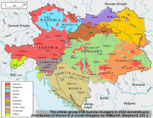
- William R. Shepherd: "Distribution of Races in Austria-Hungary", Historical Atlas, 1911 [1]
Further reading edit
- Steidl, Annemarie et al. From a Multiethnic Empire to a Nation of Nations: Austro-Hungarian Migrants in the US, 1870–1940 (Innsbruck: Studien Verlag, 2017). 354 pp.