


Summary
Etiler is a neighbourhood in the municipality and district of Beşiktaş, Istanbul Province, Turkey.[1] Its population is 11,258 (2022).[2] It is on the European side of Istanbul, close to the business quarters of Levent and Maslak.
Etiler | |
|---|---|
 Aerial view of Etiler | |
 Etiler Location in Turkey 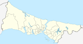 Etiler Etiler (Istanbul) | |
| Coordinates: 41°4′36″N 29°1′41″E / 41.07667°N 29.02806°E | |
| Country | Turkey |
| Province | Istanbul |
| District | Beşiktaş |
| Population (2022) | 11,258 |
| Time zone | UTC+3 (TRT) |

Etiler is famous for its upmarket cafés, pubs, night clubs, restaurants, gyms, coiffeurs, fashion shops and shopping malls, such as Akmerkez. It is a favourite area among Istanbul's elite. The quarter also has many villas and private residences.
The name Etiler is an older name in Turkish for the Hittites, as it was fashionable in the early years of the Turkish Republic to give the names of ancient Anatolian civilizations to the new districts of Istanbul. A similar example is the neighbouring quarter of Akatlar, which means Akkads, another ancient civilization from the history of Anatolia.
Shopping edit
Akmerkez is one of the best known shopping malls in Istanbul. It has all the major fashion brands, cafes and restaurants. Mayadrom is a smaller, more boutique shopping centre. Nispetiye Street is considered as the core centre of Etiler, with cafes, restaurants and designer shops.[3]
Education edit
The Istanbul Japanese School is located in Etiler.[4] Also, one of the campuses of the British International School Istanbul as well as a campus of Tarabya British Schools are located in Etiler.[5][6]
Bogazici University, which is a public university with different faculties like education, engineering, and arts and sciences, is also located in Etiler. It is situated near the end of Nispetiye Street, and has a remarkable view of the Bosphorus, as well as the Anatolian side.[7]
The middleschools, Hasan Ali Yücel Middleschool[8] and the Cumhuriyet Middleschool[9] are both located in the area as well.
Transportation edit
The M6 metro line with 4 stops; Levent, Nispetiye, Etiler & Boğaziçi Üni/Hisarüstü connects Etiler to the rest of the Istanbul Metro.[10]
There are buses from Kabatas, Taksim and Sisli to Etiler.[11]
References edit
- ^ Mahalle, Turkey Civil Administration Departments Inventory. Retrieved 12 July 2023.
- ^ "Address-based population registration system (ADNKS) results dated 31 December 2022, Favorite Reports" (XLS). TÜİK. Retrieved 12 July 2023.
- ^ Etiler Istanbul
- ^ "学校紹介 Archived 2014-03-20 at the Wayback Machine." (Archive) Istanbul Japanese School. Retrieved on January 2, 2014. "タンブリ アリ エフェンデイ ソカク NO.16 エチレル イスタンブル/Tanburi Ali Efendi Sokak NO.16 Etiler Istanbul Turkey"
- ^ "BISI City Campus". British International School Istanbul. Retrieved 2019-07-08. - Address: "Etiler Mahallesi Cengiz Topel Caddesi Tuğcular Sokak No:27"
- ^ "Contact Us". Tarabya British Schools. Retrieved 2019-07-09.
- ^ "Boğaziçi University - Home".
- ^ "Hasan Ali Yücel Middleschool Website, Contact Information".
- ^ "Cumhuriyet Middleschool Website, Contact Information".
- ^ "MetroIstanbul, Network Map".
- ^ "Oteller - Turlar - Mekanlar".
Further reading edit
- Municipality of Beşiktaş. Information on the Etiler neighbourhood. 2009.
- Dünden Bugüne İstanbul Ansiklopedisi (in Turkish). Kültür Bakanlığı, Türkiye Ekonomik ve Toplumsal Tarih Vakfı. 1993. p. 493. Retrieved 2009-08-04.
- Levine, Lynn A. (2006). Frommer's Turkey. Frommer's. pp. 89, 142. ISBN 978-0-471-78556-9. Retrieved 2009-08-04.
External links edit
- Miscellaneous images of Etiler
- Etiler Virtual Tour
![]() Media related to Etiler at Wikimedia Commons
Media related to Etiler at Wikimedia Commons