


Summary
Etna or Etne is a river in the Valdres region of Innlandet county, Norway. The 106-kilometre (66 mi) long river flows through the municipalities of Øystre Slidre, Nord-Aurdal, Etnedal, and Nordre Land before joining the river Dokka at the village of Dokka in Nordre Land Municipality. Soon after the confluence of those two rivers, they join the Randsfjorden (a long, narrow inland lake).[1]
| Etna Etne | |
|---|---|
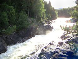 View of the Etna river, slightly north of the rock carvings at Møllerstufossen | |
 Location of the river  Etna (river) (Norway) | |
| Location | |
| Country | Norway |
| County | Innlandet |
| Municipalities | Etnedal and Nordre Land |
| Physical characteristics | |
| Source | Stortjernet lake |
| • location | Øystre Slidre, Norway |
| • coordinates | 61°18′38″N 9°14′47″E / 61.310515°N 9.246282°E |
| • elevation | 1,140 metres (3,740 ft) |
| Mouth | Dokka river |
• location | Dokka, Nordre Land, Norway |
• coordinates | 60°49′44″N 10°03′32″E / 60.8288811°N 10.058755°E |
• elevation | 140 metres (460 ft) |
| Length | 106 km (66 mi) |
| Basin size | 928.7 km2 (358.6 sq mi) |
| Discharge | |
| • average | 12.57 m3/s (444 cu ft/s) |
The river begins near the mountains Skaget and Langsua inside the Langsua National Park. It then flows in a southerly direction. Much of the river runs through the Etnedalen valley (the namesake of the municipality of Etnedal). The river runs through the village of Bruflat and then shortly after this, it begins heading in a more easterly direction. The river was formally protected from hydropower development by the government in 1993.[1]
See also edit
References edit
- ^ a b Thorsnæs, Geir, ed. (1 November 2021). "Etna (elv i Valdres)". Store norske leksikon (in Norwegian). Kunnskapsforlaget. Retrieved 1 October 2022.