


Summary
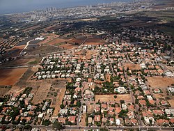
Even Yehuda (Hebrew: אֶבֶן יְהוּדָה) is a town in the central Sharon region of Israel east of Netanya.[2] In 2022 it had a population of 14,365.[1]
Even Yehuda
| |
|---|---|
Local council (from 1950) | |
 | |
 Even Yehuda  Even Yehuda | |
| Coordinates: 32°16′12.09″N 34°53′14.74″E / 32.2700250°N 34.8874278°E | |
| Country | |
| District | Central |
| Founded | 1932 |
| Government | |
| • Head of Municipality | Matan Katzman |
| Area | |
| • Total | 8,398 dunams (8.398 km2 or 3.242 sq mi) |
| Population (2022)[1] | |
| • Total | 14,365 |
| • Density | 1,700/km2 (4,400/sq mi) |
| Website | www.even-yehuda.muni.il |
History edit
The area of Even Yehuda has been inhabited intermittently since the Middle Paleolithic age, with peak periods of settlement during the Byzantine (4th - 7th centuries CE) and Late Ottoman periods (19- early 20th centuries CE).[3]
Before the 20th century, the territory of Even Yehuda formed part of the Forest of Sharon, a hallmark of the region's historical landscape. It was an open woodland dominated by Mount Tabor Oak (Quercus ithaburensis), which extended from Kfar Yona in the north to Ra'anana in the south. The local Arab inhabitants traditionally used the area for pasture, firewood and intermittent cultivation. The intensification of settlement and agriculture in the coastal plain during the 19th century led to deforestation and subsequent environmental degradation known from Hebrew sources.[4]
Even Yehuda is named for Eliezer Ben-Yehuda, one of the leading figures in the revival of the Hebrew language. It was founded in December 1932 by the Bnei Benyamin society and the Notea corporation. The economy was based on citrus growing.
In 1950, Even Yehuda became a local council, as it was merged with the nearby villages of Be'er Ganim, founded in 1932 by workers of the Dead Sea Works, and Tel Tzur, founded in 1932 by teachers of Herzliya Hebrew Gymnasium led by Haim Boger. Be'er Ganim, originally named Kfar Tzur after the Arab village Ghabat Kafr Sur from which its lands had been purchased, was renamed into its present name in 1933,[5] after a well named Bir el-Ghanem (Arabic: بئر الغنم, lit. 'sheep well') which was located in the area.[6]
Nowadays, Even Yehuda is bordered on the east by Kadima, on the south-east by Tel Mond, on the north by Lev HaSharon, on the west by Netanya and on the south-west by Hof HaSharon.[2]
In 2007, the Walworth Barbour American International School in Israel (WBAIS) moved to a new campus in Even Yehuda.[2]
Education edit
Even Yehuda has three elementary schools - "Bachar" school (בכר), "Beit Avi" school (בית אב"י) and "Rishonim" school (ראשונים), all mamlachti schools.
There is a children's village in Even Yehuda called WIZO Canada Children's village (הדסים), which is a middle school and a high school. In the village there are several kindergartens and a Democratic school.
Local features edit
- "Sharonim Gardens" (בית גני שרונים) - an assisted living facility for senior citizens
- a museum (מוזיאון הראשונים) about Even Yehuda's history and founders
Notable residents edit
- Shira Rishony (born 1991), Olympic judoka
-
 Bir Ghaneim 1878 1:63,360
 -
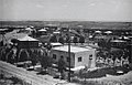 Even Yehuda. August 1938
 -
 Even Yehuda 1944 1:20,000 (middle right)
 -
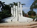 War Memorial in Even Yehudi


References edit
- ^ a b "Regional Statistics". Israel Central Bureau of Statistics. Retrieved 21 March 2024.
- ^ a b c Nahum-Halevy, Ranit (February 7, 2011). "It Takes a Village". Haaretz. Retrieved April 26, 2019.
- ^ Marom, Roy (2008). From Time Immemorial: Chapters in the History of Even Yehuda and its Region in Light of Historical and Archaeological Research (Hebrew) \ מימי קדם קדמתה: פרקים בתולדות אבן יהודה וסביבתה לאור המחקר ההיסטורי והארכיאולוגי.
- ^ Marom, Roy (2022-12-01). "יער השרון (אל-ע'אבה) בתקופה העות'מאנית: בתקופה מהמחקר חדשות תובנות הגיאוגרפי-היסטורי The Oak Forest of the Sharon (al-Ghaba) in the Ottoman Period: New Insights from Historical- Geographical Studies". Muse. 5: 90–107.
- ^ "גנים | דבר | 8 נובמבר 1933 | אוסף העיתונות | הספרייה הלאומית".
- ^ "ספר השנה של העתונאים". 1945.