


Summary
Eydoche (French pronunciation: [edɔʃ]) is a commune in the Isère department in southeastern France. It lies about 45 minutes from Grenoble on the former Route de Lyon, between Champier and Longchenal.
Eydoche | |
|---|---|
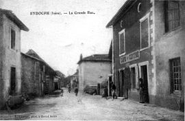 The main road in 1920 | |
Location of Eydoche .mw-parser-output .locmap .od{position:absolute}.mw-parser-output .locmap .id{position:absolute;line-height:0}.mw-parser-output .locmap .l0{font-size:0;position:absolute}.mw-parser-output .locmap .pv{line-height:110%;position:absolute;text-align:center}.mw-parser-output .locmap .pl{line-height:110%;position:absolute;top:-0.75em;text-align:right}.mw-parser-output .locmap .pr{line-height:110%;position:absolute;top:-0.75em;text-align:left}.mw-parser-output .locmap .pv>div{display:inline;padding:1px}.mw-parser-output .locmap .pl>div{display:inline;padding:1px;float:right}.mw-parser-output .locmap .pr>div{display:inline;padding:1px;float:left}html.skin-theme-clientpref-night .mw-parser-output .od,html.skin-theme-clientpref-night .mw-parser-output .od .pv>div,html.skin-theme-clientpref-night .mw-parser-output .od .pl>div,html.skin-theme-clientpref-night .mw-parser-output .od .pr>div{background:#000;color:#fff}html.skin-theme-clientpref-night .mw-parser-output .locmap{filter:grayscale(0.6)}@media(prefers-color-scheme:dark){html.skin-theme-clientpref-os .mw-parser-output .locmap{filter:grayscale(0.6)}html.skin-theme-clientpref-os .mw-parser-output .od,html.skin-theme-clientpref-os .mw-parser-output .od .pv>div,html.skin-theme-clientpref-os .mw-parser-output .od .pl>div,html.skin-theme-clientpref-os .mw-parser-output .od .pr>div{background:#000;color:#fff}}  Eydoche  Eydoche | |
| Coordinates: 45°26′32″N 5°19′54″E / 45.4422°N 5.3317°E | |
| Country | France |
| Region | Auvergne-Rhône-Alpes |
| Department | Isère |
| Arrondissement | La Tour-du-Pin |
| Canton | Le Grand-Lemps |
| Intercommunality | Bièvre Est |
| Government | |
| • Mayor (2020–2026) | Catherine Ronco[1] |
| Area 1 | 5.58 km2 (2.15 sq mi) |
| Population (2021)[2] | 540 |
| • Density | 97/km2 (250/sq mi) |
| Time zone | UTC+01:00 (CET) |
| • Summer (DST) | UTC+02:00 (CEST) |
| INSEE/Postal code | 38159 /38690 |
| Elevation | 493–629 m (1,617–2,064 ft) (avg. 510 m or 1,670 ft) |
| 1 French Land Register data, which excludes lakes, ponds, glaciers > 1 km2 (0.386 sq mi or 247 acres) and river estuaries. | |
Population edit
| Year | Pop. | ±% p.a. |
|---|---|---|
| 1968 | 312 | — |
| 1975 | 302 | −0.46% |
| 1982 | 267 | −1.74% |
| 1990 | 307 | +1.76% |
| 1999 | 331 | +0.84% |
| 2007 | 432 | +3.38% |
| 2012 | 501 | +3.01% |
| 2017 | 533 | +1.25% |
| Source: INSEE[3] | ||
Economy edit
Eydoche is a farming community, mostly dairy cattle, wheat and corn, with pastoral views. There used to be a fabric mill where very intricate jacquard fabrics were made. Many of the factory's retirees still live in the village. There is a former stone grinding mill owned by the Jullien family, where members of the family still live. Both the fabric and grinding mills were originally powered by water wheels fed from a "ruisseau" or stream.
In recent years a woodworking factory has been established. There is also a trucking company.
Sights edit
There is the village "place" with the ancient church facing the "Monument des Morts" - with the names of soldiers lost during World War I and World War II. Many of the residents of Eydoche were active in the Resistance during World War II.
The walled cemetery is a short walk from the church.
See also edit
References edit
- ^ "Répertoire national des élus: les maires" (in French). data.gouv.fr, Plateforme ouverte des données publiques françaises. 13 September 2022.
- ^ "Populations légales 2021". The National Institute of Statistics and Economic Studies. 28 December 2023.
- ^ Population en historique depuis 1968, INSEE