


Summary
Federal B. Area (Urdu: فیڈرل بی ایریا) or F. B. Area is a residential area in Karachi, Sindh, Pakistan.[1] The population of the union councils is on the higher side[clarification needed] because this is a developed area, thickly populated, and further division beyond the Census Circle is not possible. Therefore, main roads were taken as boundaries of the union councils, which restricted the population required to create union councils to 50,000.
History edit
After the independence of Pakistan in 1947, thousands of federal government employees migrated to Pakistan and faced a housing crisis. In 1953 Muhammad Ali Bogra, the Prime Minister, initiated a housing scheme for government employees named Mansura, but the name 'Federal B. Area' became much more popular among the people of Karachi.[2]
There are several ethnic groups in the area including Muhajirs, Memons, Bohras and Ismailis.
When Pakistan came into being the port city of Karachi was chosen as the capital of the federation. An area within Karachi was selected to serve as the home of federal government offices and employees and house other important buildings. This area was named Federal Capital Area or F. C. Area. The residential area around F. C. Area came to be known as Federal B Area or F. B. Area. Block 14 has a notable Ansari House near Falah Mosque and Talimi Bagh which is famous in Dastagir. {( Mr. Sohail Abdi (Ex. President District Central of PPP) and a recognized social activist resides in FB Area Block 16 from 5 decades. He performed numbers of social works for the citizens. )}
The area surrounding the F. C. and F. B. Areas were designated as buffer zones; all residential construction was barred in the buffer zone to keep the city's main population of Karachi away from the F. C. Area. However, when the capital was moved from Karachi to Islamabad, the F. C. Area's name was changed to Federal B Area.
There are 22 distinct blocks in Federal B Area. The blocks are also known by other names, including blocks 1 and 2 as Sharifabad, block 3 as Hussainabad, blocks 4, 5, and 6 as Tayyababad, blocks 7 and 8 as Azizabad, blocks 9 and 10 as Dastagir, blocks 11 and 12 as Sharifabad, blocks 14 and 15as Naseerabad, block 16 as Water Pump, blocks 17 and 18 as Samanabad, block 19 as Al-Noor Society, block 20 as Incholi, and blocks 21 and 22 as the Industrial Area.
Shahrah-e-Pakistan edit
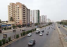
Another aspect of the area's geography is that Shahrah-e-Pakistan runs through it. This main artery of the city roughly bisects the area into two zones. The importance of the road cannot be overlooked. It is the same road which runs from the Port of Karachi to all the way to Landi Kotal in Khyber Pakhtunkhwa. Yousuf Plaza, built by Al Azam Builders, is located on Shahrah-e-Pakistan and contains around 1200 apartments, having approximately 10,000 residents. It also contains Sana's Mental Health Solutions, a psychology clinic under the supervision of Sana Asad. The biggest hospitals in the area are MAMJI Hospital, Federal Hospital and M. I. Hospital, which are also located on the main road.
Neighbourhoods edit
The area's councillor is Mudassir Hussain.
- Samanabad
- Ayesha Manzil
- Incholi
- Al-Noor
- Azizabad
- Karimabad
- Hussainabad
- Shafiq Mill Colony
- Naseerabad
- Water Pump
- Yaseenabad
- Dastagir
- Nomanabad Mansoora Block-16
See also edit
References edit