


Summary
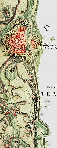
The Ferraris map or map of the Austrian Netherlands is a historical map created between 1770 and 1778 by Count Joseph de Ferraris and includes 275 sheets[1] published at the original scale of 1/11.5. The map was made in response to a request by Prince Charles Alexander of Lorraine. It is the first systematic, large scale mapping of modern-day Belgium and parts of Western Europe.

History edit
The topographic survey was performed on a territory corresponding to today's Belgium and Luxembourg as well as some territories now belonging to Germany and the Netherlands. There are three original versions of the map. The Royal Library of Belgium, the Austrian National Library and National Library of the Netherlands each have one.
Importance edit
Napoleon Bonaparte consulted the maps and subsequently used his topographical knowledge in his military campaigns.
The Ferraris maps reflect the detailed state of the Southern Netherlands just before the start of the Industrial Revolution and the end of the Ancien Régime, when the landscape was still similar to that of the Middle Ages. Looking at the maps today, it is obvious how much the areas have changed over time as people began to have a bigger impact on the environment. Environmental organizations like to use the maps to point out the original state of an area.
The maps can also help identify archaeological finds. This works both ways: archaeologists regularly use the maps to search for remains of buildings. Engineers can consult the maps to check for soil stability, since the maps feature mining pits that no longer exist but can still pose a danger.
References edit
- ^ "The Ferraris map • KBR". KBR. Retrieved 2023-04-21.
External links edit
 Media related to Category:Ferraris maps at Wikimedia Commons
- The Ferraris map on the website of the Royal Library of Belgium