
KNOWPIA
WELCOME TO KNOWPIA

Fisher Caldera 
Summary
Fisher Caldera, also known as Mount Fisher and Fisher Volcano, is a large volcanic caldera, measuring about 6.8 miles (11 km) by 11 miles (18 km), located on Unimak Island in the Aleutian Islands of Alaska.[1] Formed by the destructive eruption of an andesitic stratovolcano about 9,100 years ago,[1] it contains three crater lakes, one 2 miles (3.2 km) wide and two others about 1.5 miles (2.4 km) wide. Small peaks rising 2,000 feet (600 m) and 2,031 feet (619 m) are also present in the caldera. Fisher Caldera is located just 13 miles (21 km) from the Mount Westdahl volcano.
| Fisher Caldera | |
|---|---|
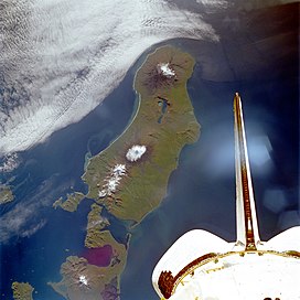 Satellite picture of Unimak Island with Fisher Caldera | |
| Highest point | |
| Elevation | 3,648 ft (1,112 m)[1] |
| Coordinates | 54°40′N 164°23′W / 54.667°N 164.383°W |
| Geography | |
| Location | Unimak Island, Alaska, United States |
| Parent range | Aleutian Range |
| Topo map | USGS Unimak C4 |
| Geology | |
| Mountain type | Stratovolcano remnant |
| Volcanic arc/belt | Aleutian Arc |
| Last eruption | August 1830 |
The largest volcanic eruption on Earth during the Holocene Epoch (the last 11,700 years) occurred at Fisher Caldera in 8700 BCE.[2]


References edit
External links edit
- "Fisher". Global Volcanism Program. Smithsonian Institution. Retrieved 2021-06-27.
See also edit