
KNOWPIA
WELCOME TO KNOWPIA

Fleurie 
Summary
Fleurie (French pronunciation: [fløʁi]) is a commune in the Rhône department in eastern France.
Fleurie | |
|---|---|
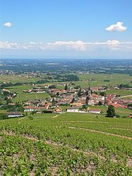 A general view of Fleurie | |
Location of Fleurie .mw-parser-output .locmap .od{position:absolute}.mw-parser-output .locmap .id{position:absolute;line-height:0}.mw-parser-output .locmap .l0{font-size:0;position:absolute}.mw-parser-output .locmap .pv{line-height:110%;position:absolute;text-align:center}.mw-parser-output .locmap .pl{line-height:110%;position:absolute;top:-0.75em;text-align:right}.mw-parser-output .locmap .pr{line-height:110%;position:absolute;top:-0.75em;text-align:left}.mw-parser-output .locmap .pv>div{display:inline;padding:1px}.mw-parser-output .locmap .pl>div{display:inline;padding:1px;float:right}.mw-parser-output .locmap .pr>div{display:inline;padding:1px;float:left}html.skin-theme-clientpref-night .mw-parser-output .od,html.skin-theme-clientpref-night .mw-parser-output .od .pv>div,html.skin-theme-clientpref-night .mw-parser-output .od .pl>div,html.skin-theme-clientpref-night .mw-parser-output .od .pr>div{background:#000;color:#fff}html.skin-theme-clientpref-night .mw-parser-output .locmap{filter:grayscale(0.6)}@media(prefers-color-scheme:dark){html.skin-theme-clientpref-os .mw-parser-output .locmap{filter:grayscale(0.6)}html.skin-theme-clientpref-os .mw-parser-output .od,html.skin-theme-clientpref-os .mw-parser-output .od .pv>div,html.skin-theme-clientpref-os .mw-parser-output .od .pl>div,html.skin-theme-clientpref-os .mw-parser-output .od .pr>div{background:#000;color:#fff}}  Fleurie  Fleurie | |
| Coordinates: 46°11′35″N 4°41′53″E / 46.193°N 4.698°E | |
| Country | France |
| Region | Auvergne-Rhône-Alpes |
| Department | Rhône |
| Arrondissement | Villefranche-sur-Saône |
| Canton | Belleville-en-Beaujolais |
| Government | |
| • Mayor (2020–2026) | Frédéric Miguet[1] |
| Area 1 | 13.94 km2 (5.38 sq mi) |
| Population (2021)[2] | 1,320 |
| • Density | 95/km2 (250/sq mi) |
| Time zone | UTC+01:00 (CET) |
| • Summer (DST) | UTC+02:00 (CEST) |
| INSEE/Postal code | 69084 /69820 |
| Elevation | 210–524 m (689–1,719 ft) (avg. 300 m or 980 ft) |
| 1 French Land Register data, which excludes lakes, ponds, glaciers > 1 km2 (0.386 sq mi or 247 acres) and river estuaries. | |
Medieval charters record Fleurie as Floriacum.[3]
Fleurie AOC is a division of the Beaujolais wine region.
In the 1970s the British Conservative politician and tax fugitive Ernest Marples (1907–78) owned a Fleurie château and vineyard, to which he retired after fleeing from an Inland Revenue investigation in 1975.[4]
Notable residents edit
- Désiré Charnay (1828–1915), archaeologist specializing in Mayan and Aztec studies
See also edit
References edit
- ^ "Répertoire national des élus: les maires". data.gouv.fr, Plateforme ouverte des données publiques françaises (in French). 2 December 2020.
- ^ "Populations légales 2021". The National Institute of Statistics and Economic Studies. 28 December 2023.
- ^ Faure-Brac, Odile. Carte archéologique de la Gaule - Le Rhône. Vol. 69/1. Paris: Académie des Inscriptions et Belles-Lettres. p. 230. ISBN 978-2-87754-096-4.
- ^ Stott, Richard (2002). Dogs and Lamposts. Toronto: Hushion House Publishing. pp. 166–171. ISBN 978-1-84358-040-9.
Wikimedia Commons has media related to Fleurie.