
KNOWPIA
WELCOME TO KNOWPIA

Florenville 
Summary
Florenville (French pronunciation: [flɔʁɑ̃vil] ⓘ; Gaumais: Floravile) is a city and municipality of Wallonia located in the province of Luxembourg, Belgium.
Florenville
Floravile (Gaumais) | |
|---|---|
City and municipality | |
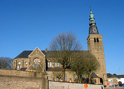 Church of Our Lady of the Assumption | |
 Coat of arms | |
Location of Florenville .mw-parser-output .locmap .od{position:absolute}.mw-parser-output .locmap .id{position:absolute;line-height:0}.mw-parser-output .locmap .l0{font-size:0;position:absolute}.mw-parser-output .locmap .pv{line-height:110%;position:absolute;text-align:center}.mw-parser-output .locmap .pl{line-height:110%;position:absolute;top:-0.75em;text-align:right}.mw-parser-output .locmap .pr{line-height:110%;position:absolute;top:-0.75em;text-align:left}.mw-parser-output .locmap .pv>div{display:inline;padding:1px}.mw-parser-output .locmap .pl>div{display:inline;padding:1px;float:right}.mw-parser-output .locmap .pr>div{display:inline;padding:1px;float:left}html.skin-theme-clientpref-night .mw-parser-output .od,html.skin-theme-clientpref-night .mw-parser-output .od .pv>div,html.skin-theme-clientpref-night .mw-parser-output .od .pl>div,html.skin-theme-clientpref-night .mw-parser-output .od .pr>div{background:#000;color:#fff}html.skin-theme-clientpref-night .mw-parser-output .locmap{filter:grayscale(0.6)}@media(prefers-color-scheme:dark){html.skin-theme-clientpref-os .mw-parser-output .locmap{filter:grayscale(0.6)}html.skin-theme-clientpref-os .mw-parser-output .od,html.skin-theme-clientpref-os .mw-parser-output .od .pv>div,html.skin-theme-clientpref-os .mw-parser-output .od .pl>div,html.skin-theme-clientpref-os .mw-parser-output .od .pr>div{background:#000;color:#fff}}  Florenville Location in Belgium
Location of Florenville in Luxembourg province 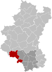 | |
| Coordinates: 49°41.9′N 5°18.6′E / 49.6983°N 5.3100°E | |
| Country | |
| Community | French Community |
| Region | Wallonia |
| Province | Luxembourg |
| Arrondissement | Virton |
| Government | |
| • Mayor | Caroline Godfrin (MR, Ambition Commune) |
| • Governing party/ies | Ambition commune - Vivr'ensemble |
| Area | |
| • Total | 148.07 km2 (57.17 sq mi) |
| Population (2018-01-01)[1] | |
| • Total | 5,629 |
| • Density | 38/km2 (98/sq mi) |
| Postal codes | 6820-6824 |
| NIS code | 85011 |
| Area codes | 061 |
| Website | www.florenville.be |

On 1 January 2016 the municipality had 5,639 inhabitants. The total area is 146.91 km2, giving a population density of 38.38 inhabitants per km2.
It is located on the Semois River, facing the French border.
The municipality consists of the following districts: Chassepierre, Florenville, Fontenoille, Lacuisine, Muno, Sainte-Cécile, and Villers-devant-Orval.
Other population centers include: Azy, Conques, Laiche, Martué, Lambermont, Le Ménil, and Watrinsart.
Orval Abbey is located in Villers-devant-Orval.
See also edit
References edit
- Union des Villes et Communes Wallones (in French)
- SPF Economy (in French)
External links edit
 Media related to Florenville at Wikimedia Commons
- Florenville official website (in French)
- ^ "Wettelijke Bevolking per gemeente op 1 januari 2018". Statbel. Retrieved 9 March 2019.