


Summary
Flower's Cove is a town in the Canadian province of Newfoundland and Labrador. The town had a population of 272 in the Canada 2021 Census. It is known for its thrombolite fossils.
Flower's Cove | |
|---|---|
Town | |
 Flower's Cove Location of Flower's Cove in Newfoundland | |
| Coordinates: 51°17′0″N 56°44′0″W / 51.28333°N 56.73333°W | |
| Country | |
| Province | |
| Population (2021) | |
| • Total | 272 |
| Time zone | UTC-3:30 (Newfoundland Time) |
| • Summer (DST) | UTC-2:30 (Newfoundland Daylight) |
| Area code | 709 |
| Highways | |
| Flower's Cove Lighthouse | |
| Constructed | 1899 (first) |
| Foundation | concrete base (current) |
| Construction | woody tower (first) metal skeletal tower (current) |
| Height | 15.5 metres (51 ft) (first) 4 metres (13 ft) (current) |
| Shape | quadrangular atop the keeper’s house with balcony and lantern (first) square pyramidal skeletal tower with balcony and light (current) |
| Markings | white tower (first) grey metal skeletal tower (current) |
| Power source | mains electricity |
| Operator | Town of Flower's Cove[1][2][3] |
| First lit | 1969 (current) |
| Deactivated | 1969 (first) |
| Focal height | 5 metres (16 ft) (current) |
| Range | 4 nmi (7.4 km; 4.6 mi) |
| Characteristic | Fl G 3s |
Geography edit
- Climate
Flower's Cove has a subarctic climate (Koppen: Dfc) per usual of the Great Northern Peninsula. Summers are short, cool and rainy, while winters are long, very cold, and snowy, with annual snowfall averaging 109 inches (277 cm). Summer typically begins by late June and can last until the end of September. Autumn is short but cool, with highs in the mid-40s (°F) and lows in the mid-30s (°F). Winter usually begins during November, sometimes late October, and can last into May. Springs are cool and relatively dry, and typically start during May and end during June, where summer begins.[4]
| Climate data for Flowers Cove 1981 to 2010 Canadian Climate Normals station data | |||||||||||||
|---|---|---|---|---|---|---|---|---|---|---|---|---|---|
| Month | Jan | Feb | Mar | Apr | May | Jun | Jul | Aug | Sep | Oct | Nov | Dec | Year |
| Record high °C (°F) | 12.0 (53.6) |
12.0 (53.6) |
10.0 (50.0) |
17.0 (62.6) |
25.0 (77.0) |
24.0 (75.2) |
25.0 (77.0) |
26.0 (78.8) |
24.5 (76.1) |
20.0 (68.0) |
17.0 (62.6) |
11.0 (51.8) |
26.0 (78.8) |
| Mean daily maximum °C (°F) | −6.5 (20.3) |
−7.0 (19.4) |
−2.3 (27.9) |
2.2 (36.0) |
7.3 (45.1) |
12.2 (54.0) |
16.6 (61.9) |
17.3 (63.1) |
13.7 (56.7) |
7.7 (45.9) |
2.6 (36.7) |
−2.4 (27.7) |
5.1 (41.2) |
| Daily mean °C (°F) | −10.8 (12.6) |
−11.4 (11.5) |
−6.2 (20.8) |
−1.0 (30.2) |
3.7 (38.7) |
7.9 (46.2) |
12.5 (54.5) |
13.4 (56.1) |
9.8 (49.6) |
4.4 (39.9) |
−0.4 (31.3) |
−5.8 (21.6) |
1.3 (34.4) |
| Mean daily minimum °C (°F) | −15.5 (4.1) |
−15.8 (3.6) |
−10.2 (13.6) |
−4.2 (24.4) |
0.1 (32.2) |
3.7 (38.7) |
8.4 (47.1) |
9.5 (49.1) |
5.9 (42.6) |
1.1 (34.0) |
−3.5 (25.7) |
−9.3 (15.3) |
−2.5 (27.5) |
| Record low °C (°F) | −30.0 (−22.0) |
−34.0 (−29.2) |
−31.0 (−23.8) |
−21.0 (−5.8) |
−9.0 (15.8) |
−4.0 (24.8) |
−1.0 (30.2) |
2.0 (35.6) |
−2.0 (28.4) |
−9.0 (15.8) |
−18.0 (−0.4) |
−29.0 (−20.2) |
−34.0 (−29.2) |
| Average precipitation mm (inches) | 87.9 (3.46) |
70.8 (2.79) |
71.9 (2.83) |
56.4 (2.22) |
76.1 (3.00) |
106.5 (4.19) |
107.6 (4.24) |
102.3 (4.03) |
99.2 (3.91) |
96.5 (3.80) |
79.3 (3.12) |
84.7 (3.33) |
1,039.2 (40.92) |
| Average rainfall mm (inches) | 16.0 (0.63) |
12.4 (0.49) |
21.8 (0.86) |
31.0 (1.22) |
70.4 (2.77) |
105.9 (4.17) |
107.6 (4.24) |
102.3 (4.03) |
99.2 (3.91) |
94.0 (3.70) |
65.6 (2.58) |
36.6 (1.44) |
762.8 (30.04) |
| Average snowfall cm (inches) | 72 (28) |
58 (23) |
50 (20) |
25 (9.8) |
6 (2.4) |
1 (0.4) |
0 (0) |
0 (0) |
0 (0) |
3 (1.2) |
14 (5.5) |
48 (19) |
277 (109.3) |
| Average precipitation days (≥ 0.2 mm) | 13.2 | 12.4 | 11.4 | 11.2 | 12.7 | 15.1 | 15.1 | 14.6 | 14.6 | 15.5 | 14.3 | 13.8 | 163.9 |
| Average rainy days (≥ 0.2 mm) | 2.4 | 2.5 | 3.6 | 6.3 | 11.7 | 15.0 | 15.1 | 14.6 | 14.6 | 15.2 | 10.1 | 4.3 | 115.4 |
| Average snowy days (≥ 0.2 cm) | 11.7 | 10.6 | 8.3 | 4.9 | 1.0 | 0.13 | 0 | 0 | 0 | 0.48 | 3.9 | 9.5 | 50.51 |
| Source: Environment Canada[5] | |||||||||||||
Demographics edit
In the 2021 Census of Population conducted by Statistics Canada, Flower's Cove had a population of 272 living in 119 of its 144 total private dwellings, a change of 0.7% from its 2016 population of 270. With a land area of 6.77 km2 (2.61 sq mi), it had a population density of 40.2/km2 (104.1/sq mi) in 2021.[6]
Sights edit
Flower's Cove is famous for thrombolites, very rare fossils which can be seen on the coast in the southern part of the town, remnants of bacteria and algae. They are about 650 million years old. The only places where thrombolites were found are Flower's Cove and Western Australia.[7]
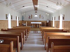
There are three churches in Flower's Cove, the most famous and largest of which is St. Barnabas Anglican Church. It is known as Skin Boot Church, as leather shoes were sold for the church fund when the church was built in the 1920s. Flower's Cove United Church is the smallest. It has a flèche instead of a spire.
Marjorie Bridge is a red-roofed bridge dating from the beginning of the 20th century.[8] It is close to the Roman Catholic Church Lady of Snow, which is more than 100 years old. The church was renovated in 2007. It is a part of Our Lady of Grace Parish in Bird Cove, which belongs to the diocese of St. George.
Gallery edit
-
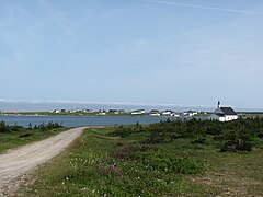
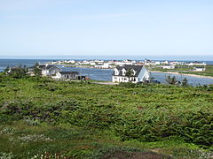 General view of the town
 -
 Thrombolites
 -
 Thrombolites
 -
 St. Barnabas Anglican Church
 -
 St. Barnabas Anglican Church
 -
 United Church
 -
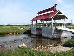 Marjorie Bridge
 -
 Catholic Church Lady of Snow
 -
 Catholic Church Lady of Snow


See also edit
References edit
- ^ Rowlett, Russ. "Lighthouses of Canada: Southwestern Newfoundland". The Lighthouse Directory. University of North Carolina at Chapel Hill. Retrieved 2017-02-15.
- ^ Flower's Cove Lighthouse Friends. Retrieved 15 February 2017
- ^ List of Lights, Pub. 110: Greenland, The East Coasts of North and South America (Excluding Continental U.S.A. Except the East Coast of Florida) and the West Indies (PDF). List of Lights. United States National Geospatial-Intelligence Agency. 2016.
- ^ Canada, Environment and Climate Change (2013-09-25). "Canadian Climate Normals 1981-2010 Station Data - Climate - Environment and Climate Change Canada". climate.weather.gc.ca. Retrieved 2020-05-28.
- ^ "Canadian Climate Normals - Climate - Environment and Climate Change Canada". 31 October 2011.
- ^ "Population and dwelling counts: Canada, provinces and territories, census divisions and census subdivisions (municipalities), Newfoundland and Labrador". Statistics Canada. February 9, 2022. Retrieved March 15, 2022.
- ^ Andrew Hampstead: Atlantic Canada, p. 380. Berkeley CA 2012.
- ^ Andrew Hampstead: Atlantic Canada, p. 379. Berkeley CA 2012.
51°17′57.42″N 56°43′42.39″W / 51.2992833°N 56.7284417°W
External links edit
- Aids to Navigation Canadian Coast Guard