
KNOWPIA
WELCOME TO KNOWPIA

Fontenu 
Summary
Fontenu (French pronunciation: [fɔ̃tny]) is a commune in the Jura department in Bourgogne-Franche-Comté in eastern France.[3]
Fontenu | |
|---|---|
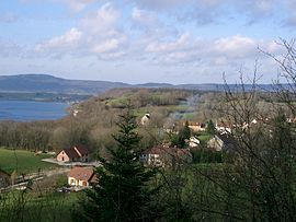 A general view of Fontenu | |
Location of Fontenu .mw-parser-output .locmap .od{position:absolute}.mw-parser-output .locmap .id{position:absolute;line-height:0}.mw-parser-output .locmap .l0{font-size:0;position:absolute}.mw-parser-output .locmap .pv{line-height:110%;position:absolute;text-align:center}.mw-parser-output .locmap .pl{line-height:110%;position:absolute;top:-0.75em;text-align:right}.mw-parser-output .locmap .pr{line-height:110%;position:absolute;top:-0.75em;text-align:left}.mw-parser-output .locmap .pv>div{display:inline;padding:1px}.mw-parser-output .locmap .pl>div{display:inline;padding:1px;float:right}.mw-parser-output .locmap .pr>div{display:inline;padding:1px;float:left}html.skin-theme-clientpref-night .mw-parser-output .od,html.skin-theme-clientpref-night .mw-parser-output .od .pv>div,html.skin-theme-clientpref-night .mw-parser-output .od .pl>div,html.skin-theme-clientpref-night .mw-parser-output .od .pr>div{background:#000;color:#fff}html.skin-theme-clientpref-night .mw-parser-output .locmap{filter:grayscale(0.6)}@media(prefers-color-scheme:dark){html.skin-theme-clientpref-os .mw-parser-output .locmap{filter:grayscale(0.6)}html.skin-theme-clientpref-os .mw-parser-output .od,html.skin-theme-clientpref-os .mw-parser-output .od .pv>div,html.skin-theme-clientpref-os .mw-parser-output .od .pl>div,html.skin-theme-clientpref-os .mw-parser-output .od .pr>div{background:#000;color:#fff}}  Fontenu  Fontenu | |
| Coordinates: 46°40′07″N 5°49′23″E / 46.6686°N 5.8231°E | |
| Country | France |
| Region | Bourgogne-Franche-Comté |
| Department | Jura |
| Arrondissement | Lons-le-Saunier |
| Canton | Saint-Laurent-en-Grandvaux |
| Government | |
| • Mayor (2020–2026) | Alexandre Perrin[1] |
| Area 1 | 6.71 km2 (2.59 sq mi) |
| Population (2021)[2] | 74 |
| • Density | 11/km2 (29/sq mi) |
| Time zone | UTC+01:00 (CET) |
| • Summer (DST) | UTC+02:00 (CEST) |
| INSEE/Postal code | 39230 /39130 |
| Elevation | 485–667 m (1,591–2,188 ft) |
| 1 French Land Register data, which excludes lakes, ponds, glaciers > 1 km2 (0.386 sq mi or 247 acres) and river estuaries. | |
Population edit
| Year | Pop. | ±% p.a. |
|---|---|---|
| 1968 | 52 | — |
| 1975 | 50 | −0.56% |
| 1982 | 47 | −0.88% |
| 1990 | 35 | −3.62% |
| 1999 | 40 | +1.49% |
| 2009 | 61 | +4.31% |
| 2014 | 73 | +3.66% |
| 2020 | 75 | +0.45% |
| Source: INSEE[4] | ||
World Heritage Site edit
It is home to one or more prehistoric pile-dwelling (or stilt house) settlements that are part of the Prehistoric Pile dwellings around the Alps UNESCO World Heritage Site.[5]
See also edit
References edit
- ^ "Répertoire national des élus: les maires". data.gouv.fr, Plateforme ouverte des données publiques françaises (in French). 9 August 2021.
- ^ "Populations légales 2021". The National Institute of Statistics and Economic Studies. 28 December 2023.
- ^ INSEE commune file
- ^ Population en historique depuis 1968, INSEE
- ^ UNESCO World Heritage Site - Prehistoric Pile dwellings around the Alps
Wikimedia Commons has media related to Fontenu.