


Summary
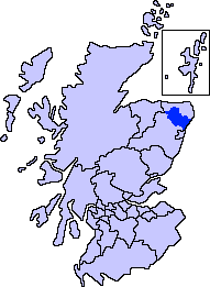
Formartine (Scottish Gaelic: Fearann Mhàrtainn meaning "Martin's land")[1] is a committee area in Aberdeenshire, Scotland. This district extends north from the River Don to the River Ythan. It has a population of 36,478 (2001 Census).
The committee area was formed in 1996 from part of the former district of Banff and Buchan.
Formartine has experienced rapid population growth, particularly around Ellon and Oldmeldrum, and in the south east where development has spread outwith the city of Aberdeen. By contrast, the area around Turriff retains strong dependency on the traditional agricultural economy. The area's coastline and rural environment offer recreation potential including the Formartine and Buchan Way.
History edit
Formartine is first documented as a thanage in 1266, when Reginald Cheyne is recorded holding it in feu-ferm and liable for 141⁄2 merks as 2nd teinds payable to the Diocese of Aberdeen.[2] This would have valued the thanage in 1266 at £96 13s 4d, though by the time of the Alexander III rental this had increased to £106 13s 4d.[3]
The thanage's origins probably lay as one of the shires within the province of Buchan that paid tribute to the King of Alba rather than the Mormaer of Buchan.[4] The thanage had its main centre at Fyvie,[5] and it included a large royal forest for hunting.[6] Formartine lay between two areas within the Earldom of Buchan: Ellon to the north east, which was the caput of the earldom, and the detached area of Bethelnie (now Oldmeldrum) to the south west.[7]
Some time between 1292 and 1296 John de Balliol, then King of Scotland, alienated the thanage to John Comyn, Earl of Buchan, as compensation for Comyn's renunciation of his claim to part of the Lordship of Galloway, Balliol's ancestral lordship.[8] This effectively extended the bounds of the Earldom southward,[9] though the burgh and castle of Fyvie remained in crown hands.[10]
The thanage must later have been escheated and returned to crown hands, as between 1341 and 1346 David II granted half of Formartine to his sister Margaret and her husband William de Moravia, 5th Earl of Sutherland, and the other half to another of his sisters Matilda and her husband Thomas Isaac.[11] Formartine reverted again to the crown in 1373 on the death of the Earl of Sutherland, and was granted in 1377 to John, Earl of Carrick, the heir to the throne, and then in 1382 as a barony to James Lindsay, the son of David Lindsay of Crawford, and Carrick compensated with a £100 per year annuity.[12]The district has a long history.[13][14]
The early history of this locale is evidenced by the survival of a number of prehistoric features, including a number of tumuli.[15]
References edit
- ^ Mac an Tàilleir, Iain (2003). "Scottish Gaelic place names F-J" (PDF). Scottish Parliament. p. 50. Retrieved 19 December 2021.
- ^ Grant 1993, pp. 55, 74.
- ^ Grant 1993, p. 62.
- ^ Broun 2015, pp. 52–53.
- ^ Young 1993, pp. 184–185.
- ^ Grant 1993, pp. 63–64.
- ^ Young 1993, pp. 183–185.
- ^ Grant 1993, pp. 69, 74.
- ^ Young 1993, p. 185.
- ^ Young 1993, pp. 197–198.
- ^ Grant 1993, pp. 66–67.
- ^ Grant 1993, p. 67, 74.
- ^ Chalmers, George (1894). Caledonia: Or, A Historical and Topographical Account of North Britain, from the Most Ancient to the Present Times; with a Dictionary of Places, Chorographical and Philological. A. Gardner.
- ^ Temple, William (1894). The Thanage of Fermartyn. Aberdeen: Wyllie. p. ix. Retrieved 3 April 2015.
- ^ Hogan, C. Michael (2008). "Catto Long Barrow fieldnotes". The Modern Antiquarian. Retrieved 15 September 2009.
Bibliography edit
- Broun, Dauvit (2015). "Statehood and lordship in 'Scotland' before the mid-twelfth century". Innes Review. 66 (1): 1–71. doi:10.3366/inr.2015.0084. Retrieved 23 December 2021.
- Grant, Alexander (1993). "Thanes and Thanages, from the Eleventh to the Fourteenth Centuries". In Grant, Alexander; Stringer, Keith J. (eds.). Medieval Scotland: Crown, Lordship & Community. Edinburgh: Edinburgh University Press. pp. 39–81. ISBN 0748604189.
- Young, Alan (1993). "The Earls and Earldom of Buchan in the Thirteenth Century". In Grant, Alexander; Stringer, Keith J. (eds.). Medieval Scotland: Crown, Lordship & Community. Edinburgh: Edinburgh University Press. pp. 174–202. ISBN 0748604189.
57°23′46″N 2°17′13″W / 57.39611°N 2.28694°W