


Summary
Fouras, also known as Fouras-les-Bains (French pronunciation: [fuʁa le bɛ̃]), is a commune in the French department of Charente-Maritime, administrative region of New Aquitaine (before 2015: Poitou-Charentes). It lies 34 km south of La Rochelle.
Fouras | |
|---|---|
 A general view of Fouras | |
 Coat of arms | |
Location of Fouras .mw-parser-output .locmap .od{position:absolute}.mw-parser-output .locmap .id{position:absolute;line-height:0}.mw-parser-output .locmap .l0{font-size:0;position:absolute}.mw-parser-output .locmap .pv{line-height:110%;position:absolute;text-align:center}.mw-parser-output .locmap .pl{line-height:110%;position:absolute;top:-0.75em;text-align:right}.mw-parser-output .locmap .pr{line-height:110%;position:absolute;top:-0.75em;text-align:left}.mw-parser-output .locmap .pv>div{display:inline;padding:1px}.mw-parser-output .locmap .pl>div{display:inline;padding:1px;float:right}.mw-parser-output .locmap .pr>div{display:inline;padding:1px;float:left}html.skin-theme-clientpref-night .mw-parser-output .od,html.skin-theme-clientpref-night .mw-parser-output .od .pv>div,html.skin-theme-clientpref-night .mw-parser-output .od .pl>div,html.skin-theme-clientpref-night .mw-parser-output .od .pr>div{background:#000;color:#fff}html.skin-theme-clientpref-night .mw-parser-output .locmap{filter:grayscale(0.6)}@media(prefers-color-scheme:dark){html.skin-theme-clientpref-os .mw-parser-output .locmap{filter:grayscale(0.6)}html.skin-theme-clientpref-os .mw-parser-output .od,html.skin-theme-clientpref-os .mw-parser-output .od .pv>div,html.skin-theme-clientpref-os .mw-parser-output .od .pl>div,html.skin-theme-clientpref-os .mw-parser-output .od .pr>div{background:#000;color:#fff}}  Fouras  Fouras | |
| Coordinates: 45°59′16″N 1°05′35″W / 45.9878°N 1.0931°W | |
| Country | France |
| Region | Nouvelle-Aquitaine |
| Department | Charente-Maritime |
| Arrondissement | Rochefort |
| Canton | Châtelaillon-Plage |
| Intercommunality | CA Rochefort Océan |
| Government | |
| • Mayor (2021–2026) | Daniel Coirier[1] |
| Area 1 | 9.51 km2 (3.67 sq mi) |
| Population (2021)[2] | 4,061 |
| • Density | 430/km2 (1,100/sq mi) |
| Demonym | Fourasin·e[a] |
| Time zone | UTC+01:00 (CET) |
| • Summer (DST) | UTC+02:00 (CEST) |
| INSEE/Postal code | 17168 /17450 |
| Elevation | 0–21 m (0–69 ft) |
| 1 French Land Register data, which excludes lakes, ponds, glaciers > 1 km2 (0.386 sq mi or 247 acres) and river estuaries. | |
Geography edit
Fouras is on a peninsula. It is bordered by five beaches and a forest named "Bois Vert" ("Green Wood" in English) which covers 20% of its area.
There is a causeway linking Fouras to Fort Énet, which is walkable at low tide, in the direction of Île-d'Aix. The pier for the island of Aix is also located in the territory of the commune.
The south coast of the peninsula of Fouras forms the northern side of the mouth of the river Charente. A little further south is the Île d'Oléron. Off the island between Aix and the Oleron Island is Fort Boyard, which was made famous by the French and U.K. TV game shows of the same name and whose character "Père Fouras" ([pɛʁ fuʁa], also incorrectly pronounced [pɛʁ fuʁas]) increased the celebrity of the town.
Population edit
|
| ||||||||||||||||||||||||||||||||||||||||||||||||||||||||||||||||||||||||||||||||||||||||||||||||||||||||||||||||||
| Source: EHESS[3] and INSEE (1968-2017)[4] | |||||||||||||||||||||||||||||||||||||||||||||||||||||||||||||||||||||||||||||||||||||||||||||||||||||||||||||||||||
Vauban Fortress edit
The "Vauban Fortress" (French: fort Vauban, [fɔʁ vobɑ̃]) was initially a strategic fortification established by Philip the Fair, circa 1300. The donjon was rebuilt in 1480-1490 by Jehan II de Brosse. In 1689, Ferry reinforced the walls of the Donjon to set up a battery of 9 canons and a signaling point. In 1693 a lower circular battery was set up to control access to the river Charente. The donjon received a signal station from 1889 to World War II.[5]
Gallery edit
-
 Fisherman's Cabin
 -
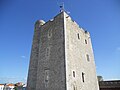 Fouras donjon in the "Vauban Fortress".
 -
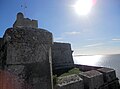 The "Vauban Fortress" (Fort Vauban) in Fouras.
 -


People edit
See also edit
International relations edit
 , Agia Paraskevi, Greece
 , Geroskipou, Cyprus
References edit
- ^ "Répertoire national des élus: les maires". data.gouv.fr, Plateforme ouverte des données publiques françaises (in French). 9 August 2021.
- ^ "Populations légales 2021". The National Institute of Statistics and Economic Studies. 28 December 2023.
- ^ Des villages de Cassini aux communes d'aujourd'hui: Commune data sheet Fouras, EHESS (in French).
- ^ Population en historique depuis 1968, INSEE
- ^ Local notice
External links edit
 Media related to Fouras at Wikimedia Commons
- ^ Demonym pronunciation: [fuʁazɛ̃], [fuʁazin]