
KNOWPIA
WELCOME TO KNOWPIA

French Island (California) 
Summary
French Island is a small island in the Sacramento–San Joaquin River Delta.[2] It is part of Solano County, California. Its coordinates are 38°15′51″N 121°41′38″W / 38.26417°N 121.69389°W[1], and the United States Geological Survey measured its elevation as 0 ft (0 m) in 1981.[1] It appears on USGS maps in 1952 and 1978, with the same shape and elevation.[3][4]
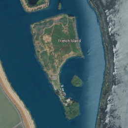 USGS aerial imagery of French Island; Hastings Tract is across Cache Slough to the west, and the flooded Liberty Island is across Shag Slough to the east. | |
 French Island  French Island  French Island | |
| Geography | |
|---|---|
| Location | Northern California |
| Coordinates | 38°15′51″N 121°41′38″W / 38.26417°N 121.69389°W[1] |
| Adjacent to | Sacramento–San Joaquin River Delta |
| Highest elevation | 0 ft (0 m)[1] |
| Administration | |
United States | |
| State | |
| County | Solano |

References edit
- ^ a b c d U.S. Geological Survey Geographic Names Information System: French Island
- ^ "Species". Napa Valley Register. Napa, California. 2020-04-17. p. B3.
- ^ United States Geological Survey (1952). "Liberty Island Quadrangle, California" (Map). United States Department of the Interior Geological Survey. 1:24000.
- ^ United States Geological Survey (1978). "Liberty Island Quadrangle, California" (Map). United States Department of the Interior Geological Survey. 1:24000.