
KNOWPIA
WELCOME TO KNOWPIA

Freneuse, Seine-Maritime 
Summary
Freneuse (French pronunciation: [fʁənøz]) is a commune in the Seine-Maritime department in the Normandy region in northern France.
Freneuse | |
|---|---|
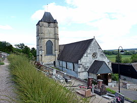 The church in Freneuse | |
Location of Freneuse .mw-parser-output .locmap .od{position:absolute}.mw-parser-output .locmap .id{position:absolute;line-height:0}.mw-parser-output .locmap .l0{font-size:0;position:absolute}.mw-parser-output .locmap .pv{line-height:110%;position:absolute;text-align:center}.mw-parser-output .locmap .pl{line-height:110%;position:absolute;top:-0.75em;text-align:right}.mw-parser-output .locmap .pr{line-height:110%;position:absolute;top:-0.75em;text-align:left}.mw-parser-output .locmap .pv>div{display:inline;padding:1px}.mw-parser-output .locmap .pl>div{display:inline;padding:1px;float:right}.mw-parser-output .locmap .pr>div{display:inline;padding:1px;float:left}html.skin-theme-clientpref-night .mw-parser-output .od,html.skin-theme-clientpref-night .mw-parser-output .od .pv>div,html.skin-theme-clientpref-night .mw-parser-output .od .pl>div,html.skin-theme-clientpref-night .mw-parser-output .od .pr>div{background:#000;color:#fff}html.skin-theme-clientpref-night .mw-parser-output .locmap{filter:grayscale(0.6)}@media(prefers-color-scheme:dark){html.skin-theme-clientpref-os .mw-parser-output .locmap{filter:grayscale(0.6)}html.skin-theme-clientpref-os .mw-parser-output .od,html.skin-theme-clientpref-os .mw-parser-output .od .pv>div,html.skin-theme-clientpref-os .mw-parser-output .od .pl>div,html.skin-theme-clientpref-os .mw-parser-output .od .pr>div{background:#000;color:#fff}}  Freneuse  Freneuse | |
| Coordinates: 49°18′32″N 1°03′51″E / 49.3089°N 1.0642°E | |
| Country | France |
| Region | Normandy |
| Department | Seine-Maritime |
| Arrondissement | Rouen |
| Canton | Caudebec-lès-Elbeuf |
| Intercommunality | Métropole Rouen Normandie |
| Government | |
| • Mayor (2020–2026) | Pascal Baron[1] |
| Area 1 | 3.18 km2 (1.23 sq mi) |
| Population (2021)[2] | 994 |
| • Density | 310/km2 (810/sq mi) |
| Time zone | UTC+01:00 (CET) |
| • Summer (DST) | UTC+02:00 (CEST) |
| INSEE/Postal code | 76282 /76410 |
| Elevation | 3–75 m (9.8–246.1 ft) (avg. 11 m or 36 ft) |
| 1 French Land Register data, which excludes lakes, ponds, glaciers > 1 km2 (0.386 sq mi or 247 acres) and river estuaries. | |
Geography edit
A farming village situated in a meander of the river Seine some 8 miles (13 km) south of the centre of Rouen, at the junction of the D92 and the D292 roads.
Population edit
| Year | Pop. | ±% p.a. |
|---|---|---|
| 1968 | 575 | — |
| 1975 | 730 | +3.47% |
| 1982 | 1,024 | +4.95% |
| 1990 | 1,033 | +0.11% |
| 1999 | 951 | −0.91% |
| 2007 | 936 | −0.20% |
| 2012 | 910 | −0.56% |
| 2017 | 932 | +0.48% |
| Source: INSEE[3] | ||
Places of interest edit
- The church of Notre-Dame, dating from the sixteenth century.
- The chateau at the hamlet of Beaudoin.
- The seventeenth-century chateau du Val-Freneuse
See also edit
References edit
- ^ "Répertoire national des élus: les maires" (in French). data.gouv.fr, Plateforme ouverte des données publiques françaises. 13 September 2022.
- ^ "Populations légales 2021". The National Institute of Statistics and Economic Studies. 28 December 2023.
- ^ Population en historique depuis 1968, INSEE
Wikimedia Commons has media related to Freneuse (Seine-Maritime).