
KNOWPIA
WELCOME TO KNOWPIA

Fresselines 
Summary
Fresselines (French pronunciation: [fʁɛslin]; Occitan: Fraisselinas) is a commune in the Creuse department in the Nouvelle-Aquitaine region in central France.
Fresselines | |
|---|---|
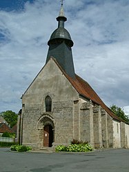 The church in Fresselines | |
Location of Fresselines .mw-parser-output .locmap .od{position:absolute}.mw-parser-output .locmap .id{position:absolute;line-height:0}.mw-parser-output .locmap .l0{font-size:0;position:absolute}.mw-parser-output .locmap .pv{line-height:110%;position:absolute;text-align:center}.mw-parser-output .locmap .pl{line-height:110%;position:absolute;top:-0.75em;text-align:right}.mw-parser-output .locmap .pr{line-height:110%;position:absolute;top:-0.75em;text-align:left}.mw-parser-output .locmap .pv>div{display:inline;padding:1px}.mw-parser-output .locmap .pl>div{display:inline;padding:1px;float:right}.mw-parser-output .locmap .pr>div{display:inline;padding:1px;float:left}html.skin-theme-clientpref-night .mw-parser-output .od,html.skin-theme-clientpref-night .mw-parser-output .od .pv>div,html.skin-theme-clientpref-night .mw-parser-output .od .pl>div,html.skin-theme-clientpref-night .mw-parser-output .od .pr>div{background:#000;color:#fff}html.skin-theme-clientpref-night .mw-parser-output .locmap{filter:grayscale(0.6)}@media(prefers-color-scheme:dark){html.skin-theme-clientpref-os .mw-parser-output .locmap{filter:grayscale(0.6)}html.skin-theme-clientpref-os .mw-parser-output .od,html.skin-theme-clientpref-os .mw-parser-output .od .pv>div,html.skin-theme-clientpref-os .mw-parser-output .od .pl>div,html.skin-theme-clientpref-os .mw-parser-output .od .pr>div{background:#000;color:#fff}}  Fresselines  Fresselines | |
| Coordinates: 46°23′01″N 1°40′58″E / 46.3836°N 1.6828°E | |
| Country | France |
| Region | Nouvelle-Aquitaine |
| Department | Creuse |
| Arrondissement | Guéret |
| Canton | Dun-le-Palestel |
| Intercommunality | CC Pays Dunois |
| Government | |
| • Mayor (2020–2026) | Jean-Louis Laverdant[1] |
| Area 1 | 30.78 km2 (11.88 sq mi) |
| Population (2021)[2] | 493 |
| • Density | 16/km2 (41/sq mi) |
| Time zone | UTC+01:00 (CET) |
| • Summer (DST) | UTC+02:00 (CEST) |
| INSEE/Postal code | 23087 /23450 |
| Elevation | 200–366 m (656–1,201 ft) (avg. 200 m or 660 ft) |
| 1 French Land Register data, which excludes lakes, ponds, glaciers > 1 km2 (0.386 sq mi or 247 acres) and river estuaries. | |
Geography edit
A tourism and farming village situated some 20 miles (32 km) northwest of Guéret, at the junction of the D76 and the D44 roads, where the river Petite Creuse joins the Creuse.
Population edit
| Year | Pop. | ±% |
|---|---|---|
| 1962 | 1,057 | — |
| 1968 | 1,123 | +6.2% |
| 1975 | 983 | −12.5% |
| 1982 | 846 | −13.9% |
| 1990 | 735 | −13.1% |
| 1999 | 671 | −8.7% |
| 2008 | 629 | −6.3% |
Sights edit
- The church of St.Julien, dating from the twelfth century.
- The two 15th-century châteaux of Puyguillon and Vervix
- Two 15th-century chapels.
Personalities edit
- Maurice Rollinat (1846–1903), poet, lived here.
- Gustave Geffroy, (1855–1926), writer, lived here.
- Claude Monet, painter, spent much time here.

See also edit
References edit
- ^ "Répertoire national des élus: les maires". data.gouv.fr, Plateforme ouverte des données publiques françaises (in French). 9 August 2021.
- ^ "Populations légales 2021". The National Institute of Statistics and Economic Studies. 28 December 2023.
Wikimedia Commons has media related to Fresselines.