


Summary
Fukutoku-Okanoba (福徳岡ノ場) is a submarine volcano that is part of the Volcano Islands in the Bonin Islands of Japan. It is located five kilometers (3.1 mi) northeast of the island of South Iwo Jima.
| Fukutoku-Okanoba | |
|---|---|
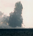
 The eruption smoke rises, and the fountain is emitted from the inside, giving it a coxtail shape on January 20, 1986 | |
| Highest point | |
| Elevation | −29 metres (−95 ft)[1] |
| Coordinates | 24°16′48″N 141°29′06″E / 24.28°N 141.485°E |
| Geography | |
 Fukutoku-Okanoba | |
| Geology | |
| Mountain type | Submarine volcano |
| Last eruption | August 2021 |
Geography edit
The volcano is part of a larger elongated submarine volcano with two peaks and with a magma composition of trachyandesite. The volcano itself has erupted on multiple occasions with the last eruption before 2021 occurring during 2010. The first island to form when this volcano was discovered formed in 1904–5 and with a few more forming during the course of the 1900s.[2]
History edit
The earliest recorded eruption of Fukutoku-Okanoba in 1904 formed an ephemeral island named Shin-Iwo-jima (New Sulfur Island). Other ephemeral islands have also formed, the most recent of which formed in 1986.[3] In 2010, the Japanese coast guard spotted steam rising one kilometer (0.62 mi) above the ocean and water discoloration of the surrounding area.[1] In 2021, the Japan Meteorological Agency (JMA) reported that a submarine eruption occurred at Fukutoku-Okanoba volcano at 6:20 a.m. local time on August 13.[4] On August 16, it was confirmed that a new island had formed as a result of the latest eruption.[5]
In October 2021, large quantities of pumice pebbles from Fukutoku-Okanoba damaged fisheries, tourism, the environment, 11 ports in Okinawa and 19 ports in Kagoshima prefecture.[6] Clean-up operations took 2–3 weeks.[6]
Timeline edit
- 1904 - 1905 : height 145 m (476 ft), is substantially circular island around about 7.2 km (4.5 mi) is formed by submarine eruption.[7] In June 1905, it shrank to a height of less than 3 m (9.8 ft) and eventually became a reef .
- 1914 : An island with a height of 300 m (980 ft) and a circumference of 11.8 km (7.3 mi) is formed by a submarine eruption in January.[7] At the end of the year, collapses will begin in various places.
- 1916 : The island is submerged.
- 1986 : An island was formed by a submarine eruption in January, but the island submerged in a short period of time until the end of March.[7]
- 2005 : The submarine eruption on July 2 creates a huge water vapor column with a height of 1,000 m (3,300 ft) and a diameter of 50–100 m (160–330 ft).
- 2007 : On December 1, the Japan Meteorological Agency began announcing eruption warnings . Since then, "warning of surrounding sea areas" has been continued.
- 2008 : Discolored water was confirmed for several months from around February.[8]
- 2010 : Due to the submarine eruption on February 3, eruptions and discolored water are observed in the surrounding area.[9][10]
- 2013 : On September 27, observations by the Maritime Self-Defense Force confirmed a green discoloration of the sea surface and the eruption of white bubbles on the sea surface within a radius of 450 m (1,480 ft).[11]
- 2020 : On February 4, yellow-green discolored water was confirmed by the Japan Coast Guard observation.
- 2021 : On August 13, the eruption of the seafloor was observed. The height is about 17,000 m (56,000 ft). Volcanic lightning was also observed. Volcanic ash is Bashi Channel beyond the South China Sea has been reached in the northeastern part.[12] This eruption is considered to be one of the largest in Japan after the war.[13] Observations by the Japan Coast Guard on August 15 confirmed Niijima, which is about 1 km (0.62 mi) in diameter.[14] On August 17, Niijima was divided into two parts, east and west, and on October 20, it was confirmed that Niijima on the east side had disappeared.[13] In October, a large amount of pumice seen to have erupted in this eruption, or more distant 1,000 km (620 mi) Daito , Okinawa , Amami drifted to coast around.[13][15][16]
Gallery edit
-
 Eruption situation of Fukutoku Okanoba (Jan 20, 1986)
 -
 Fukutoku Okanoba and South Iwo Jima during eruption activity (Jan 20, 1986)
 -
 Pumice stones lifted by the eruption fill the surface of the sea. The distant island is South Iwo Jima (Jan 20, 1986)
 -
 Himawari-8 satellite images of the August 12 to August 13, 2021 eruption of Fukutoku-Okanoba


See also edit
References edit
- ^ a b "Fukutoku-Oka-no-Ba". Global Volcanism Program. Smithsonian Institution. Retrieved 2017-02-28.
- ^ "Fukutoku-Okanoba". www.volcanodiscovery.com. Archived from the original on 2021-08-16. Retrieved 2021-08-16.
- ^ "Fukutoku-Oka-no-Ba: Photo Gallery". Global Volcanism Program. Smithsonian Institution. Retrieved 2021-06-24.
- ^ "Fukutoku-Okanoba volcano (Volcano Islands, Japan): submarine explosion today". Volcano Discovery. August 13, 2021. Archived from the original on August 14, 2021. Retrieved August 14, 2021.
- ^ "Fukutoku-Okanoba volcano (Japan): new island born in the Pacific". Volcano Discovery. August 16, 2021. Archived from the original on August 21, 2021. Retrieved March 2, 2022.
- ^ a b "Japan ports swamped by pumice spewed from undersea volcano". The Guardian. October 30, 2021. Archived from the original on October 30, 2021.
- ^ a b c "福徳岡ノ場 有史以降の火山活動". 気象庁. Archived from the original on 2021-08-13. Retrieved 2021-08-16.
- ^ "平成20年(2008年)の福徳岡ノ場の火山活動" (PDF). 気象庁地震火山部 火山監視情報センター. Archived (PDF) from the original on 2021-08-13. Retrieved 2021-08-16.
- ^ "南硫黄島近海で白煙、新島出現の可能性も". 読売新聞. 2010-02-04. Archived from the original on 2010-02-04. Retrieved 2013-12-25.
- ^ "福徳岡ノ場の海底噴火" (PDF). かいほジャーナル. 42 (2010年春号). 海上保安庁: 1. 2010-03-26. Archived from the original (PDF) on 2013-08-24. Retrieved 2013-12-25.
- ^ "阿蘇山噴火の可能性 9月の火山活動 気象庁". ハザードラボ. Archived from the original on 2014-03-11. Retrieved 2014-03-11.
- ^ "Volcanic Ash Graphic Initial 142100UTC August 2021". VAAC Tokyo. Archived from the original on 2021-08-15. Retrieved 2021-08-14.
- ^ a b c "「福徳岡ノ場」噴火、戦後最大級と判明 桜島「大正噴火」に次ぐ規模". 毎日新聞. 2021-10-23. Archived from the original on 2021-10-23.
- ^ "海底火山の福徳岡ノ場で新島確認 過去は海没、噴石に警戒". 共同通信. 2021-08-16. Archived from the original on 2021-08-16. Retrieved 2021-08-16.
- ^ "沖縄・北大東島を取り巻く灰色ライン 謎の漂着物の正体は?". 琉球新報. 2021-10-08. Archived from the original on 2021-10-08.
- ^ "1450キロ離れた沖縄本島にも「軽石」漂着 小笠原の海底火山噴火の影響か". 琉球新報. 2021-10-14. Archived from the original on 2021-10-14.
External links edit
- Article on 2005 eruption