


Summary
Fulford is a historic village and civil parish on the outskirts of York, in the York district, in the ceremonial county of North Yorkshire, England. Fulford is located 2 miles (3 km) to the south of the city, on the east bank of the River Ouse.
| Fulford | |
|---|---|
 Main Street, Fulford | |
 Fulford Location within North Yorkshire | |
| Population | 2,785 (2011 census)[1] |
| OS grid reference | SE608495 |
| • London | 175 mi (282 km) S |
| Civil parish |
|
| Unitary authority | |
| Ceremonial county | |
| Region | |
| Country | England |
| Sovereign state | United Kingdom |
| Post town | YORK |
| Postcode district | YO10, YO19 |
| Police | North Yorkshire |
| Fire | North Yorkshire |
| Ambulance | Yorkshire |
| UK Parliament | |
| Website | www |
The population of the civil parish at the 2011 census was 2,785.[1] It is home to Imphal Barracks, headquarters of the British Army's 15th Infantry Brigade; soldiers and their families live in married quarters outside the barracks. Fulford is a headquarters for the Royal Military Police.
Fulford was the site of the Battle of Fulford won by the invading Vikings in 1066, a precursor to the nearby Battle of Stamford Bridge lost by the Vikings, and then the Battle of Hastings in Sussex won by the invading Normans in the following weeks.
History edit
St Oswald's Hall, the former church, was built about 1150, on a site near the Ouse, west of the current village centre. A new St Oswald's Church was built, on a different site, in 1866, and the old church also survives.[2]
Cavalry barracks were established in Fulford as early as 1795 but these have now been largely demolished.[3] The infantry barracks, now known as Imphal Barracks were built between 1877 and 1880.[3]

Fulford Cross, a 15th-century Grade II listed boundary cross stands opposite the barracks, beyond the present parish boundary.[4] The cross has been removed, but an octagonal shaft on a three-stepped pedestal remains.

In 1823 Fulford, known as "Fulford Gate", was a village in the parish of Fulford Ambo in the East Riding of Yorkshire and the Wapentake of Ouse and Derwent. Population at the time was 182, with occupations including two farmers, two blacksmiths, two wheelwrights, two shoemakers, a butcher, a tailor, a shopkeeper, a coal dealer, a corn miller, and the landlords of The Light Horseman, The Saddle, The Board, The Plough, and The Bay Horse public houses. Also within the village was a druggist, a manufacturing chemist, a schoolmaster, nine gentlemen, three gentlewomen, two bankers and seven yeomen. A school existed for 20 boys and girls. Within the parish of Fulford Ambo, and 1 mile (1.6 km) to the south of Fulford Gate, was the settlement of Fulford Water, with a population of 35 which included three farmers, and a gentleman at the Hall.[5]
The ancient parish of Fulford consisted of two townships, Gate Fulford (also known as Over Fulford) in the north and Water Fulford (also known as Nether Fulford) to the south. From the two townships the parish took the name of Fulfords Ambo in the 19th century. The two townships became separate civil parishes in 1866. In 1900 the civil parish of Gate Fulford was abolished and absorbed into the city of York.[6] The civil parish of Water Fulford was renamed Fulford in 1935.[7]
In 1974 Fulford was transferred from the East Riding of Yorkshire to Selby District in the new county of North Yorkshire. In 1996 the parish was transferred to the City of York unitary authority.[8]
Geography and governance edit

According to the 2001 Census the parish had a population of 2,595.[9] The modern village incorporates the old settlements of Water Fulford to the south and Gate Fulford on the road to York. The current civil parish is co-terminous with the unitary authority ward boundary. The parish is much reduced in size, having once extended north up the A19 past Fulford Barracks as far as Heslington Road and including York Cemetery. Between Fulford and the university is Walmgate Stray. Low-lying land near the River Ouse is prone to flooding.[10]
The parish council maintains a website with local information which includes a directory of organisations and shops, a list of links and contact details for services, a guide to local issues and a record of parish council minutes.[11]
Education edit

Schools in the area include St. Oswald's Primary School and Fulford School, a Mathematics and Computing College.
Transport edit
Fulford main street is the A19. Near the intersection stands the York Designer Outlet shopping mall. A pedestrian Millennium Bridge with a cycle path was opened in 2001, linking Fulford to the South Bank area of York on the other side of the river.[12] Several bus services operate between York and Fulford.
Sport edit

Fulford Golf Club, which celebrated its centenary in 2006, was home to the Benson and Hedges International Open between 1971 and 1989. During the 1981 tournament, Bernard Langer climbed 20 feet (6.1 m) up an ash tree by the 17th green to play his third shot.[13][14] York City F.C. were once based in Fulford, at their Fulfordgate stadium, before moving to the current Bootham Crescent stadium in 1932. The area is now occupied by Eastward Avenue and lies close to Fulford School.
A 6.4 miles (10.3 km) long scale model of the Solar System starts across the Ouse, west of Fulford, and runs via Naburn to Riccall along a disused railway line from York to Selby, now a Sustrans cycle path and part of the White Rose cycle route.[15]
Besides having the Minster Way and the Wilberforce Way,[16] the route of The White Rose Way, a long-distance walk from Leeds to Scarborough also passes through Fulford.[17]
Notable people edit
- Steve McClaren – former England football manager, was born in Fulford.[18]
Gallery edit
-
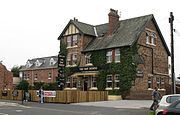
 The Fulford Arms
 -
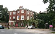
 The Bay Horse
 -
-
 Fulford Methodist Church
 -
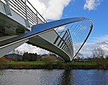 Millennium Bridge
 -


References edit
- ^ a b UK Census (2011). "Local Area Report – Fulford Parish (1170211387)". Nomis. Office for National Statistics. Retrieved 21 March 2018.
- ^ A History of the County of York East Riding. Vol. 3. London: Victoria County History. 1976. Retrieved 25 August 2021.
- ^ a b "A History of Imphal Barracks" (PDF). Ministry of Defence. Retrieved 29 March 2014.
- ^ Historic England. "Fulford Cross, Fulford Road (1257807)". National Heritage List for England. Retrieved 25 April 2012.
- ^ Baines, Edward (1823): History, Directory and Gazetteer of the County of York, pp. 208–209
- ^ Great Britain Historical GIS / University of Portsmouth, Gate Fulford. Retrieved 26 December 2021.
- ^ Allison, K. J., ed. (1976). "Fulford". Victoria County History. A History of the County of York East Riding: Volume 3. pp. 29–36. Retrieved 26 December 2021.
- ^ "The North Yorkshire (District of York) (Structural and Boundary Changes) Order 1995". Retrieved 26 December 2021.
- ^ UK Census (2001). "Local Area Report – Fulford Parish (00FF011)". Nomis. Office for National Statistics. Retrieved 1 May 2020.
- ^ "New homes would increase flood 'strain'". BBC News. 7 January 2016. Retrieved 1 May 2020.
- ^ Fulford Parish Council York; Fulfordpc.org.uk. Retrieved 25 April 2012
- ^ "Archive: The opening of Millennium Bridge in York". York Press. 24 February 2017. Retrieved 26 May 2017.
- ^ "Fulford Golf Club". todaysgolfer.co.uk. Retrieved 1 May 2020.
- ^ "Red carpet treatment for Fulford B&H champs". York Press. 8 May 2003. Retrieved 1 May 2020.
- ^ "Cycle the Solar System"; Solar.york.ac.uk. Retrieved 25 April 2012
- ^ "290" (Map). York. 1:25,000. Explorer. Ordnance Survey. 2015. ISBN 9780319244876.
- ^ "White Rose Way". www.ldwa.org.uk. Retrieved 1 May 2020.
- ^ "Steve McClaren profile". The Football Association. Archived from the original on 21 May 2008.
External links edit
![]() Media related to Fulford at Wikimedia Commons
Media related to Fulford at Wikimedia Commons