


Summary
The Funeral Mountains is a short, arid mountain range in the United States along the California-Nevada border approximately 100 mi (160 km) west of Las Vegas. The mountains are considered a subrange of the Amargosa Range that form the eastern wall of Death Valley.
| Funeral Mountains | |
|---|---|
 Pyramid Peak seen from Ash Meadows in Nevada | |
| Highest point | |
| Elevation | 2,043 m (6,703 ft) |
| Geography | |
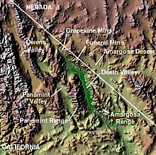
 Location of Funeral Mountains in California[1] | |
| Country | United States |
| State | California |
| District | Inyo County |
| Range coordinates | 36°23′30″N 116°36′43″W / 36.39167°N 116.61194°W |
| Topo map | USGS East of Echo Canyon |
The crest of the range is within Death Valley National Park. The range is separated from the Grapevine Mountains to the northwest by the narrow Boundary Canyon[2] and is separated from the Black Mountains by Furnace Creek Wash on the southwest and from the Greenwater Range at the narrow Travertine Point on the south.[3] The broad flats of the Amargosa Desert lie across the border to the northeast in Nevada.[2] The highest point in the range is Pyramid Peak, at 6703 ft (2043 m).[4][5]
The first movement of Ferde Grofé's Death Valley Suite is a symphonic musical portrayal of pioneer settlers trudging through the dry craggy peaks of the Funeral Mountains.

References edit
- ^ "Funeral Mountains". Geographic Names Information System. United States Geological Survey, United States Department of the Interior. Retrieved 2009-05-03.
- ^ a b Beatty, Nevada–California, 30x60 Minute Topographic Quadrangle, USGS, 1986
- ^ Death Valley Junction, California Nevada, 30x60 Topographic Quadrangle, USGS, 1986
- ^ "Pyramid Peak". Geographic Names Information System. United States Geological Survey, United States Department of the Interior. Retrieved 2009-05-03.
- ^ East of Echo Canyon, Calif.–Nev., 7.5 Minute Topographic Quadrangle, USGS, 1987
External links edit
- BLM: Funeral Mountain Wilderness